
Barcarrota
| Barcarrota parish | |||
|---|---|---|---|
| coat of arms | Map of Spain | ||

|
|
||
| Basic data | |||
| Autonomous Community : | Extremadura | ||
| Province : | Badajoz | ||
| Coordinates | 38 ° 31 ′ N , 6 ° 51 ′ W | ||
| Height : | 467 msnm | ||
| Area : | 136.1 km² | ||
| Residents : | 3,510 (Jan 1, 2019) | ||
| Population density : | 25.79 inhabitants / km² | ||
| Postal code : | 06160 | ||
| Municipality number ( INE ): | 06016 | ||
| administration | |||
| Website : | www.barcarrota.es | ||

Barcarrota is a municipality ( municipio ) in the province of Badajoz in western Spain about 48 km south of the provincial capital Badajoz . Barcarrota is on the N-435 road from Badajoz to Jerez de los Caballeros .
The place has about 3510 inhabitants (as of January 1, 2019), a bullring and a town center with narrow streets. There is a fishing area for wild carp at the reservoir ten kilometers away. There is a stand of oaks on the way from Barcarrota to the reservoir .
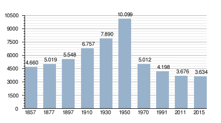
Development of the population
Web links
Individual evidence
- ↑ Cifras oficiales de población resultantes de la revisión del Padrón municipal a 1 de enero . Population statistics from the Instituto Nacional de Estadística (population update).
Acedera | Aceuchal | Ahillones | Alange | La Albuera | Alburquerque | Alconchel | Alconera | Aljucén | Almendral | Almendralejo | Arroyo de San Serván | Atalaya | Azuaga | Badajoz | Barcarrota | Baterno | Benquerencia de la Serena | Berlanga | Bienvenida | Bodonal de la Sierra | Burguillos del Cerro | Cabeza del Buey | Cabeza la Vaca | Calamonte | Calera de León | Calzadilla de los Barros | Campanario | Campillo de Llerena | Capilla | Carmonita | El Carrascalejo | Casas de Don Pedro | Casas de Reina | Castilblanco | Castuera | La Codosera | Cordobilla de Lácara | La Coronada | Corte de Peleas | Cristina | Cheles | Don Álvaro | Don Benito | Entrín Bajo | Esparragalejo | Esparragosa de la Serena | Esparragosa de Lares | Feria | Fregenal de la Sierra | Fuenlabrada de los Montes | Fuente de Cantos | Fuente del Arco | Fuente del Maestre | Fuentes de León | Garbayuela | Garlitos | La Garrovilla | Granja de Torrehermosa | Guadiana del Caudillo | Guareña | La Haba | Helechosa de los Montes | Herrera del Duque | Higuera de la Serena | Higuera de Llerena | Higuera de Vargas | Higuera la Real | Hinojosa del Valle | Hornachos | Jerez de los Caballeros | La Lapa | Lobón | Llera | Llerena | Magacela | Maguilla | Malcocinado | Malpartida de la Serena | Manchita | Medellín | Medina de las Torres | Mengabril | Mérida | Mirandilla | Monesterio | Montemolín | Monterrubio de la Serena | Montijo | La Morera | La Nava de Santiago | Navalvillar de Pela | Nogales | Oliva de la Frontera | Oliva de Mérida | Olivenza | Orellana de la Sierra | Orellana la Vieja | Palomas | La Parra | Peñalsordo | Peraleda del Zaucejo | Puebla de Alcocer | Puebla de la Calzada | Puebla de la Reina | Puebla de Obando | Puebla de Sancho Pérez | Puebla del Maestre | Puebla del Prior | Pueblonuevo del Guadiana | Quintana de la Serena | Reina | Rena | Retamal de Llerena | Ribera del Fresno | El Risco | La Roca de la Sierra | Salvaleón | Salvatierra de los Barros | San Pedro de Mérida | San Vicente de Alcántara | Sancti-Spiritus | Santa Amalia | Santa Marta de los Barros | Los Santos de Maimona | Segura de León | Siruela | Solana de los Barros | Talarrubias | Talavera la Real | Táliga | Tamurejo | Torre de Miguel Sesmero | Torremayor | Torremejía | Trasierra | Trujillanos | Usagre | Valdecaballeros | Valdelacalzada | Valdetorres | Valencia de las Torres | Valencia del Mombuey | Valencia del Ventoso | Valverde de Burguillos | Valverde de Leganés | Valverde de Llerena | Valverde de Mérida | Valle de la Serena | Valle de Matamoros | Valle de Santa Ana | Villafranca de los Barros | Villagarcía de la Torre | Villagonzalo | Villalba de los Barros | Villanueva de la Serena | Villanueva del Fresno | Villar de Rena | Villar del Rey | Villarta de los Montes | Zafra | Zahínos | Zalamea de la Serena | La Zarza | Zarza Capilla