Alange
| Alange municipality | ||
|---|---|---|
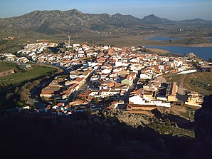
 Alange - location view
|
||
| coat of arms | Map of Spain | |

|
|
|
| Basic data | ||
| Autonomous Community : | Extremadura | |
| Province : | Badajoz | |
| Comarca : | Tierra de Mérida - Vegas Bajas | |
| Coordinates | 38 ° 47 ′ N , 6 ° 15 ′ W | |
| Height : | 325 msnm | |
| Area : | 160.29 km² | |
| Residents : | 1,848 (Jan 1, 2019) | |
| Population density : | 11.53 inhabitants / km² | |
| Postal code : | 06840 | |
| Municipality number ( INE ): | 06004 | |
| administration | ||
| Website : | Alange | |
Alange is a place and a municipality ( municipio ) with 1,848 inhabitants (as of 2019) in the Spanish province of Badajoz in the autonomous community of Extremadura .
location
The place Alange is today on the bank of the Alange dam, completed in 1992, approx. 27 km (driving distance) southeast of Merida at an altitude of approx. 325 m above sea level. d. The climate in winter is temperate, in summer it is warm to hot; the low rainfall (approx. 520 mm / year) falls - with the exception of the almost rainless summer months - distributed over the whole year.
Population development
| year | 1857 | 1900 | 1950 | 2000 | 2016 |
| Residents | 1,761 | 1,844 | 3,240 | 2,057 | 1.915 |
The population decline in the second half of the 20th century is mainly due to the mechanization of agriculture and the associated loss of jobs.
economy
Already in antiquity, the place was privileged by its location and its thermal springs . While the surrounding area was largely agricultural for centuries, traders, craftsmen and service providers of all kinds settled in the village.
history
In Roman times , Alange was on a hill above the Río Matachel on the Via de la Plata , an ancient road connection between Hispalis ( Seville ) and Asturica Augusta ( Astorga ). The place also had several thermal springs. The castle (castillo) dates back to this time (at that time it was called Castrum Culubri ); however, it was changed again and again later. In 1234 the castle and town during the reconquest were ( reconquista ) occupied by the Christians; even Ibn Hud , who a few years earlier had ended the rule of the Almohads in Al-Andalus , suffered an injury. In the 14th century the castle and place were given to the Santiagoorden .
Attractions
- The thermal springs rediscovered in the 18th century, including the Roman baths , were expanded in the 19th century and recently redesigned in parts.
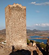
- The castle, built in the Moorish period (9th / 10th century) instead of a Roman fortification on the Cerro de la Culebra , was expanded after the reconquest by the Christians. You can see the remains of three towers and the central keep (torre del homenaje) .
- The single-nave church of Nuestra Senora de los Milagros is a building from the first half of the 16th century. Its masonry is a mixture of largely uncut natural stones (mampostería) and bricks (ladrillos) . The main entrance is on the south side; the entire portal zone shows reddish sandstone worked out late Gothic forms (lateral pinnacles , medium ogee ). The windows are made of the same stone material.
Web links
Individual evidence
- ↑ Cifras oficiales de población resultantes de la revisión del Padrón municipal a 1 de enero . Population statistics from the Instituto Nacional de Estadística (population update).
- ↑ Alange - map with altitude information
- ↑ Alange - climate tables
- ^ Alange - population development
- ↑ Alange - History
- ^ Alange - Roman bath
- ^ Alange - Castle
- ^ Alange Church

