Ahillones
| Ahillones parish | ||
|---|---|---|
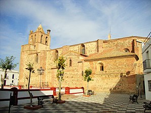
 Ahillones - Iglesia de Santa María de los Remedios
|
||
| coat of arms | Map of Spain | |

|
|
|
| Basic data | ||
| Autonomous Community : | Extremadura | |
| Province : | Badajoz | |
| Comarca : | Campiña Sur | |
| Coordinates | 38 ° 16 ′ N , 5 ° 52 ′ W | |
| Height : | 580 msnm | |
| Area : | 21.54 km² | |
| Residents : | 871 (Jan 1, 2019) | |
| Population density : | 40.44 inhabitants / km² | |
| Postal code : | 06940 | |
| Municipality number ( INE ): | 06003 | |
| administration | ||
| Website : | Ahillones | |
Ahillones is a small town and a municipality ( municipio ) with 871 inhabitants (as of 2019) in the southeast of the Spanish province of Badajoz in the autonomous community of Extremadura .
location
The place Ahillones is a good 130 km southeast of the provincial capital Badajoz or just 112 km southeast of Mérida at an altitude of about 580 m above sea level. d. The climate in winter is temperate, in summer it is warm to hot; the rather low amounts of precipitation (approx. 630 mm / year) fall - with the exception of the almost rainless summer months - distributed over the whole year.
Population development
| year | 1857 | 1900 | 1950 | 2000 | 2016 |
| Residents | 1,977 | 2,414 | 3,027 | 1,200 | 934 |
The significant population decline in the second half of the 20th century is mainly due to the mechanization of agriculture and the resulting loss of jobs.
economy
The people of earlier times lived essentially on farming as self-sufficiency ; Traders, craftsmen and service providers of all kinds also settled in the village.
history
Celtic, Roman and Visigoth traces have not yet been discovered in the municipality. In the early 8th century the region was overrun by the Moors , who, however, settled under the Leonese King Alfonso IX. (ruled 1188-1230) had to deal with the Christian reconquest ( reconquista ) , which could be stopped by the Almohads until the battle of Las Navas de Tolosa (1212). The final reconquest of the southwest of the Iberian Peninsula took place under the Leonese-Castilian King Ferdinand III. (reg. 1230-1252). He handed the place over to the Order of Santiago in 1246 . In 1646 Philip IV (ruled 1621-1665) raised the place to the rank of city.
Attractions
- The most important attraction of the place is the church of Santa María de los Remedios , built in the first half of the 16th century , whose outer walls in Mudejar tradition consist of a mixture of broken stone and bricks and are stabilized by buttresses . The four round corner turrets on the bell tower are unusual . Two renaissance portals lead into the single nave interior of the church.
- The Ermita del Santo Cristo de la Sangre dates from the 16th century, but was changed to Baroque style in the 18th century.
Web links
- Ahillones, history etc. - photos + information (Spanish)
- Ahillones, sights - photos + information (Spanish)
Individual evidence
- ↑ Cifras oficiales de población resultantes de la revisión del Padrón municipal a 1 de enero . Population statistics from the Instituto Nacional de Estadística (population update).
- ↑ Ahillones - Map with altitude information
- ↑ Ahillones - climate tables
- ↑ Ahillones - Population Development
- ↑ http://www.dip-badajoz.es/municipios/municipio_dinamico/historia/index_historia.php?codigo=003
- ↑ Ahillones - history ( page no longer available , search in web archives ) Info: The link was automatically marked as defective. Please check the link according to the instructions and then remove this notice.
- ↑ Ahillones Church
