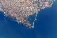
La Manga del Mar Menor
La Manga del Mar Menor is a recreation and holiday area in the Murcia region , Spain and is part of the administrative areas of the two municipalities of Cartagena and San Javier . Due to its location and its mild Mediterranean climate, the strip is also known as part of the Costa Cálida .
Surname
The name La Manga del Mar Menor is a composite landscape name consisting of the headland La Manga (German: sleeve, but also hose) and the salt lake Mar Menor (German: smaller sea).
La Manga
The approximately 22 km long and between 100 to 1500 m wide spit was formed by the formation of sand deposits by the prevailing ocean currents, in the interior of which lies the Mar Menor salt lake. La Manga is interrupted by four natural channels ( golas ) that ensure the flow of water between the Mar Menor and the open Mediterranean. La Manga is delimited between two natural areas: "Parque Regional de las Salinas" and "Arenales de San Pedro" in the north and the "Salinas de Marchamalo" and "Las Amoladeras" in the south. The 44 km long beaches are distinguished on the one hand by the beaches of the Mar Menor and on the other hand by the typical beaches of the Mediterranean.
Panorama La Manga
Mar Menor
Mar Menor with a circumference of 73 km and an area of around 170 km² is the largest salty inland water in Europe. The average water depth is 2.5 m, the maximum 6.5 m. With a salt content of 42 to 47 g / l (the highest value in Europe), the water is said to have healing therapeutic effects.
natural reserve
La Manga del Mar Menor is bordered by the nature reserves Parque Regional de las Salinas and Arenales de San Pedro in the north and the Salinas de Marchamalo and Las Amoladeras in the south. La Manga was in 1982 by the United Nations for Specially Protected Area of Mediterranean Importance explained and is on of the UNEP led managed SPAMI list.
climate
La Manga del Mar Menor has an average of 320 days of sunshine a year and around 3000 hours of sunshine. Rain rarely falls, less than 300 liters a year, mostly in the months from January to May. This influences the water temperatures with 11 ° C in winter and over 30 ° C in summer. The average temperature during the year is 17 ° C. In June, July, August and September it rises to values above 31 ° C. The winters are relatively mild, as temperatures do not fall below 10 ° C on average in the coldest months.
The thermal inertia in the lagoon is lower than that in the Mediterranean. In view of the shallow depths on certain coastal strips, temperatures between 18 ° C and 36 ° C can be determined here in summer. The spatial distribution of the water is, however, uniform, so that the differences in different areas are limited to below 1–2 ° C.
language
In the region around La Manga del Mar Menor, a separate dialect is spoken, known as Murciano or Panocho. It often differs significantly from the actual Castellano and contains loan words from Catalan , such as the Cabo de Palos lighthouse is called Cap de Pals . This notation can also be found on many maps and publications.
traffic
The international Aeropuerto Internacional de la Región de Murcia , which opened in 2019, is 40 or 50 kilometers away from the lagoon (north or south side of the spit) . There is a railroad connection from Cartagena via Murcia to Alicante and from there to Barcelona . Another route leads to Lorca . Road traffic is supplied with the Autopista del Mediterráneo AP-7 and the N-332 in north-south direction, dual for local and long-distance traffic.
In the direct vicinity of the lagoon is the former international airport of San Javier , which has also been used for civil purposes since 1995 and which has only been used for military purposes since January 2019.
tourism
La Manga's infrastructure includes hotel complexes, apartment complexes, campsites, harbors, sailing schools, recreation centers, supermarkets, shops, bars and discos, some of which are also open in winter and autumn.
Due to its location between lake and sea, La Manga is also a well-known place for water sports. There are sailing and water ski schools that offer regular courses, as well as windsurfing and catamaran courses. Diving is also practiced around Cabo de Palos and the rocky depths next to Isla Grosa.
beaches
The 44 km long beaches differ on the one hand by the salt sea beaches of the Mar Menor and on the other hand by the typical beaches of the Mediterranean Sea.
Islands in the Mar Menor
- Isla Perdiguera
- Isla Mayor also Isla del Barón
- Isla del Ciervo
- Isla Grosa (in the Mediterranean)
Web links
- Lamanga.net website (Spanish)
Individual evidence
- ↑ Llengua i literatura: Revista anual de la Societat Catalana de Llengua i literatura , ISSN 0213-6554 , Nº. 13, 2002, pags. 505-510
Coordinates: 37 ° 44 ′ N , 0 ° 44 ′ W


