
List of mountains and elevations in Denmark
The list of mountains and elevations in Denmark shows a selection of mountains or elevations that are in the area of the actual national territory of Denmark (excluding the Faroe Islands and Greenland ) - sorted by height in meters. The highest mountains or elevations can be found in the Ejer Bjerge , a mountain range between Horsens and Skanderborg in the east of the Midtjylland region (Central Jutland).
Until 1847 the 147 meter high Himmelbjerget was considered the highest mountain in Denmark, after which the Ejer Bavnehøj was proclaimed the highest mountain in the country until 1941 . Measurements in 1941 showed, however, that the middle burial mound on Yding Skovhøj is higher than Ejer Bavnehøj. Between 1953 and 2005, Ejer Bavnehøj regained its top position among the highest elevations in Denmark with a height difference of 6 cm, which was assumed at the time. The question of the extent to which burial mounds and other man-made mounds can be included led to heated discussions in Denmark for decades. In 2004/2005 a study by researchers from the mapping and land registry authorities provided clarity (Kort & Matrikelstyrelsen ) from the Danish Ministry of the Environment , the Geografisk Institut of the University of Copenhagen and the Danish National Museum , which have resulted in the ranking of Denmark's highest survey having to be rearranged. The highest natural elevation in the country turned out to be Møllehøj (170.86 m),200 m west of Ejer Bavnehøj, while the middle burial mound of Yding Skovhøj was determined to be the highest elevation, including man-made mounds, at 172.54 m.
On Zealand , Denmark's largest island, the highest point is called Kobanke (122.9 m), but this fact is also based on a narrow decision by geologists. Gyldenløves Høj , a little further north, is 125.5 m high and was often referred to as the highest point in Zealand until 2007. However, an investigation showed that its natural height is only 121.3 m.
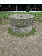
Marking of the highest natural point in Denmark, Møllehøj (170 m)
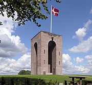
Lookout tower from 1924 on Ejer Bavnehøj (170 m)

Himmelbjerget (147 m) with a lookout tower from 1875


List of the highest natural elevations
List of highest peaks including man-made mounds

| No. | Elevation | height | location | Geographic coordinates |
|---|---|---|---|---|
| 1. | Yding Skovhøj , middle burial mound | 172.54 m | Ejer Bjerge, eastern Midtjylland | 55 ° 59 ′ 33 " N , 9 ° 47 ′ 45" E |
| 2. | Vistofte burial mound | 171.73 m | Ejer Bjerge, eastern Midtjylland | |
| 3. | Yding Skovhøj , eastern burial mound | 171.73 m | Ejer Bjerge, eastern Midtjylland | 55 ° 59 ′ 33 " N , 9 ° 47 ′ 45" E |
| 4th | Yding Skovhøj , western burial mound | 171.41 m | Ejer Bjerge, eastern Midtjylland | 55 ° 59 ′ 33 " N , 9 ° 47 ′ 45" E |
| 5. | Ejer Bavnehøj , modern height | 171.04 m | Ejer Bjerge, eastern Midtjylland | 55 ° 58 '37 .3 " N , 9 ° 49' 50.3" E |
| 6th | Møllehøj | 170.86 m | Ejer Bjerge, eastern Midtjylland | 55 ° 58 '37.9 " N , 9 ° 49' 34.4" E |
| 7th | Lindbjerg | 170.08 m | Ejer Bjerge, eastern Midtjylland | |
| 8th. | Margretelyst SØ (Southeast) | 169.78 m | Ejer Bjerge, eastern Midtjylland |
Other surveys (selection)
- Skamlingsbanken , Kolding municipality (113 m)
- Ellemandsbjerg , Syddjurs municipality (99 m)
- Knivsberg , Aabenraa municipality (97 m)
- Vongshøj , Tønder Kommune (62 m)
See also
Web links
- Nyt højeste punkt i Danmark Announcement by the map and land registry ( Kort & Matrikelstyrelsen ) of the Danish Ministry of the Environment on the new highest point in Denmark on February 28, 2005 (Danish)
- Danske Bjerge: De højeste danske tinder (Danish); Highest peaks of Denmark (English)
References and comments
- ↑ Den Store Danske : Ejer Bavnehøj , accessed on October 27, 2011 (Danish)
- ↑ a b c Kort & Matrikelstyrelsen: Nyt højeste dot i Danmark of February 28, 2005, accessed on October 27, 2011 (Danish)
- ↑ Note: In the ranking list, the first six surveys refer to the official information from the Kort & Matrikelstyrelsen of the Danish Ministry of Environment , while the order of the subsequent surveys is taken from the website Danskebjerge.dk .
- ^ Danske Bjerge: Highest points in Denmark
- ↑ a b Note: The hill has no official name
- ↑ Note: If the 4.5 m high burial mound is included, the height of Ottehøje is 145 m.
Albania | Andorra | Belgium | Bosnia and Herzegovina | Bulgaria | Denmark | Germany | Estonia | Finland | France | Greece | Ireland | Iceland | Italy | Kosovo | Croatia | Latvia | Liechtenstein | Lithuania | Luxembourg | Malta | Moldova | Monaco | Montenegro | Netherlands | North Macedonia | Norway | Austria | Poland | Portugal | Romania | Russia | San Marino | Sweden | Switzerland | Serbia | Slovakia | Slovenia | Spain | Czech Republic | Ukraine | Hungary | Vatican City | United Kingdom | Belarus