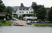
Lohfeld (Bad Honnef)
Lohfeld (also the Lohfeld ) is a district of the city of Bad Honnef in the North Rhine-Westphalian Rhein-Sieg district . It is located on the Rhine in the outer southwest of the urban area.
The Lohfeld extends from the Rolandsmühle in the south at the Grenzbach Honnefer Graben , which flows into the Rhine here and at the same time forms the border to the local community Rheinbreitbach and thus to Rhineland-Palatinate , to the level of the Grafenwerth island in the north. It is located on the westernmost branch of the broad Honnef debris cone, in which groundwater flows down from the mountains to the Rhine. The residential development extends largely on the Rhine side along the central connecting axis of Lohfelder Straße ( Kreisstraße 26). Free-standing single houses with large land areas that extend as far as the Rhine determine the area up to the northern section, which is dominated by a row house settlement from the post-war period. In the middle of Lohfeld, west of the railway line, lies an industrial and commercial area that characterizes the district. ABB and Bad Honnef AG , two important companies for the city, have their headquarters there, as did Birkenstock .
To the south, the Lohfeld is closed off by a former fruit tree plantation, now undeveloped grassland, which forms the core of a drinking water protection area that extends as far as Rheinbreitbach . In the outer south of the Lohfeld is the Uhlhof , the former location of the Academy for International Cooperation . On the Rhine there is also the Arntz Castle, the former country house of the explorer Emil Arntz and, since March 1981, a water control station for the state of North Rhine-Westphalia, which is supposed to measure the water quality of the river after crossing the nearby state border. Further north, at river kilometer 640, a Rhine ferry crosses over to Rolandseck , which goes back to a former yaw ferry . The ferry place also bears the historical name Lohfelderfähre , in 1885 it had nine inhabitants.
The place name Lohfeld goes on field names back to the descriptions Aufm Lohfeld or Down on Lohfeld contributed. The place was mentioned early in 1343 as loyfeld (= "low wood, bushes, grove, forest"), followed in 1643 as luffeltzien ("Lohfeld-Sey"). In the year 1302, however, the so-called Lohfelder Weiher was named as piscina lovelt . This body of water, which was only recognizable by its remains as early as 1652, had an elongated shape and in the south a connection to the still existing ponds of the Rheinbreitbacher Maar . Extending parallel to the Rhine, it reached in the north up to the level of the southern city center. The Lohfelder Weiher was very likely a remnant of an earlier arm of the Rhine. From around the 13th century, the Lohfeld was the location of the execution site of Honnef and the Löwenburg office , which had a size of three quarters of acres and was abandoned in 1788 at the latest. The land (weir) ditch created in the 16th century on the border between the Duchy of Berg in the north and the Electorate of Cologne in the south was previously secured in the area of the Lohfeld by ditches, fences and hedges.
Individual evidence
- ↑ District government of Cologne: Explanatory report on the delimitation of the water protection area for the catchment area of the Lohfelder Straße groundwater extraction plant of Bad Honnef AG (PDF; 279 kB)
- ↑ The water protection zone could become building land ( Memento of October 12, 2011 in the Internet Archive ) , General-Anzeiger , April 13, 2006
- ^ Karl Gutzmer : Chronicle of the city of Bonn . Chronik-Verlag, Dortmund 1988, ISBN 3-611-00032-9 , p. 262.
- ^ Community encyclopedia for the Kingdom of Prussia , Volume XII Provinz Rheinland, Verlag des Königlich Statistischen Bureaus (Ed.), 1888, page 115
- ↑ Helmut Arntz (with the assistance of Adolf Nekum ): Urkataster und Gewannen: using the example of the community of Honnef 1824/1826. (= Heimat- und Geschichtsverein “Herrschaft Löwenburg” e.V .: studies on the local history of the town of Bad Honnef am Rhein. Issue 13, Bad Honnef 2000; Society for the History of Wine e.V . : writings on wine history. ISSN 0302-0967 , No. 133, Wiesbaden 2000), pp. 67/68.
- ↑ J [ohann] J [oseph] Brungs : The city of Honnef and its history . Verlag des St. Sebastianus-Schützenverein, Honnef 1925, p. 158 (reprinted 1978 by Löwenburg-Verlag, Bad Honnef).
- ↑ Heimat- und Geschichtsverein Rhöndorf (ed.); August Haag : Pictures from the past of Honnef and Rhöndorf . Complete production JP Bachem, Cologne 1954, p. 83.
- ^ Christian Helfer: Position features of the gallows place on the lower Middle Rhine. In: Karl Meisen (ed.): Rheinisches Jahrbuch für Volkskunde . Ferd. Dümmler Verlag, 13th and 14th year, Bonn 1963, p. 47.
- ↑ Helmut Arntz (with the assistance of Adolf Nekum ): Urkataster und Gewannen: using the example of the community of Honnef 1824/1826. (= Heimat- und Geschichtsverein “Herrschaft Löwenburg” e.V .: studies on the local history of the town of Bad Honnef am Rhein. Issue 13, Bad Honnef 2000; Society for the History of Wine e.V . : writings on wine history. ISSN 0302-0967 , No. 133, Wiesbaden 2000), p. 160.
Web links
Coordinates: 50 ° 37 '53 " N , 7 ° 12' 55" E


