
Mannheim harbor
| Mannheim harbor | |||
|---|---|---|---|
| Data | |||
| UN / LOCODE | DE MHG | ||
| operator | State Rhein-Neckar-Hafengesellschaft Mannheim mbH, BASF u. A. | ||
| opening | 1828 | ||
| Port type | Ports and Lands | ||
| Throughput | 8.6 million t (2016) | ||
| Container (TEU) | 140,000 (2014) | ||
| website | http://www.hafen-mannheim.de/de/startseite.html | ||
| Geographic information | |||
| place | Mannheim | ||
| country | Baden-Württemberg | ||
| Country | Germany | ||
 |
|||
| Coordinates | 49 ° 30 '43 " N , 8 ° 26' 16" E | ||
|
|||

The Mannheim port is the fourth largest inland port and one of the most important in Europe . The port has 2,679,000 m² of water and 8,635,000 m² on land. Almost 500 companies with 20,000 jobs are located in the port area. Mannheim opened the first container terminal in an inland port in 1968 . There is also a roll-on-roll-off system (RoRo) and, since 1991, a terminal for combined transport .
In 2014, 8.45 million tonnes of goods were handled on the waterside. Container traffic rose by 2.64% to 1.39 million t compared to the previous year. The waterside container traffic was 140,823 TEU (standard container). 16,904 vehicles were handled at the RoRo facility.
Solid mineral fuels accounted for the largest share of the total throughput with 2.36 million t, food and animal feed with 1.88 million t (excluding agricultural and forestry products) and chemical products with 1.03 million t.
In 2016, 8.6 million t of goods were handled on the waterside.
Location and transport links
The port basins are distributed around the confluence of the Rhine and Neckar rivers and their old arms. Within Mannheim they are all on the western outskirts. The Ludwigshafen am Rhein ports , which are located directly opposite on the left bank of the Rhine , complete the complex .
In Mannheim, the Rhine and Neckar have the status of a federal waterway . Transhipment to the railroad is made possible with the help of the Mannheim marshalling yard , the second largest marshalling yard in Germany. Further transport by road takes place on the federal highways and motorways in the area ( see: Road traffic in Mannheim ).
Port outline

The port of Mannheim is divided into four ports, each with several basins:
|
|
|
|
history

Since the first mention of water tariffs on the Neckar mouth in 1247 , the leaves inland waterways in Mannheim evidence. In 1607 Mannheim was granted city rights, and it was expanded into a trading and storage area. In 1827 the Grand Duke of Baden approved the construction of a free port . It was opened a year later (today roughly: connecting channel). The port had to be expanded as early as 1840. In 1854 the port received its first rail connection. In 1868 the Mannheim Act was passed, which regulated the free movement of goods on the Rhine. In 1875 the Mühlauhafen was opened, and French prisoners of war who had surrendered after the siege of Metz were also used in the construction . In 1887 the inland port was built. In 1901 the Rheinauhafen (basins 21-23) was built by private investors. After a short time they ran into financial difficulties, so that the state took over the site in 1903. In 1913, another private basin, the Thyssen Harbor (basin 24), was built, which was taken over in 1958. Until the end of the 19th century, Mannheim was the de facto end point of large-scale shipping on the Rhine. The port was therefore a transshipment point for all of southwest Germany including Alsace-Lorraine , Switzerland and parts of Austria. Due to the regulation of the Rhine according to the plans of Tulla and the impending expansion of the Neckar, the Mannheim port threatened to lose its importance. The industrial port was built by 1907, and companies settled here that processed the incoming goods directly. As a result, the port was no longer a pure trading center and was able to maintain its position. By 1913 the largest German milling center was built and a quarter of the German grain trade was carried out here.
The First World War brought radical changes with the Treaty of Versailles . With Alsace-Lorraine, an important part of the hinterland was lost, and France even built a rival port in Strasbourg . And Mannheim had to give up the seat of the Rhine Shipping Commission . During the Second World War , the port was the preferred bombing target of the Allies and suffered severe damage.
After the reconstruction, several changes had to be responded to: the ships on the Rhine kept getting bigger, so the inland port was too small and was filled in by 1974. The emerging mineral oil industry was met with the opening of the oil port in 1964. The movement of goods changed from bulk to piece goods. Therefore, the first German container terminal was built at an inland port in 1968 . In 1977 more containers were handled in Mannheim than in all other German inland ports combined. At Rheinauhafenbecken 21 there was a huge coal storage of the US Army until 2002 , with which all of southern Germany was to be supplied in the event of a crisis. The RoRo facility was opened in 1983 and the KLV terminal in 1991 . In 2001 the port of Mannheim signed a cooperation agreement with the port of Ludwigshafen on the opposite side of the Rhine.

Diffené bridge between the Altrheinhafen and the industrial port
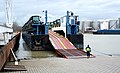
RoRo facility in Rheinauhafen, basin 24

Old level clock in the harbor 21

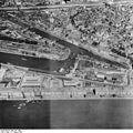
Mühlauhafen, container terminal on the right
Commercial port 1953

Mühlauhafen around 1905

.jpg)


economy
Below are some well-known companies that are located in or near the port and purchase their raw materials via the port or ship their goods.
literature
- The Mannheim ports. Plans with explanations . Municipal Port and Industry Office, Mannheim 1932.
- Rudolf Haas, Karl Hoffmann: 150 years Rheinhafen Mannheim . State Port Authority, Mannheim 1978, ISBN 3-87804-065-2
- Hanspeter Rings: Mannheim on course. History of the port and shipping of the city on the Rhine and Neckar (= small writings of the Mannheim City Archives No. 20) v. Brandt, Mannheim 2003, ISBN 3-926260-57-2
Web links
- Mannheim harbor
- Port cooperation Mannheim + Ludwigshafen
- Guide to the industrial and port facilities of Mannheim, Rheinau and Ludwigshafen (1909)
Individual evidence
- ^ Port of Mannheim, history of the port
- ^ Mannheim and Ludwigshafen stable . In: Daily port report of January 31, 2017, p. 13
- ↑ Albert Kuntzemüller : The Baden Railways in the Franco-German War 1870/71 (= supplement to: Report of the Realgymnasium with Realschule Mannheim, Lessing School . School year 1913/14, ZDB -ID 1059960-5 ). Masur, Mannheim 1914, p. 13