
Maisinger Bach
|
Maisinger Bach (Georgenbach) |
||
 The catchment area of the Maisinger Bach with the local brook names. The most important moraine lines are shown in brown. |
||
| Data | ||
| Water code | DE : 16462 | |
| location | Europe , Germany , Bavaria | |
| River system | Danube | |
| Drain over | Starnberger See → Würm → Amper → Isar → Danube → Black Sea | |
| origin | Kerschlacher Forst 47 ° 55 ′ 48 ″ N , 11 ° 12 ′ 58 ″ E |
|
| Source height | 720 m above sea level NHN | |
| muzzle |
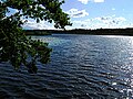
Starnberger See near Starnberg Coordinates: 47 ° 59 ′ 49 ″ N , 11 ° 21 ′ 0 ″ E 47 ° 59 ′ 49 ″ N , 11 ° 21 ′ 0 ″ E |
|
| Mouth height | 584 m above sea level NHN | |
| Height difference | 136 m | |
| Bottom slope | 7.4 ‰ | |
| length | 18.4 km | |
| Catchment area | 47.65 km² | |
| Runoff at the Starnberg gauge |
MNQ MQ MHQ |
105 l / s 479 l / s 5.98 m³ / s |
| Medium-sized cities | Starnberg | |
 Georgenbach in Starnberg |
||
The Maisinger Bach (Georgenbach) is after the Ostersee-Ach with an average water flow of 0.479 m³ / s the second largest tributary of the Starnberger See , to whose total catchment area it contributes about 49 km² or about 15 percent. The Maisinger Bach and its tributaries drain a depression between Lake Starnberg and Lake Ammersee , which is framed in the west and east by the lateral moraines of the glacier tongues of the Isar-Loisach Glacier from the Wurmi -Age.
The Maisinger Bach arises from several source brooks that arise in the Kerschlacher Forest, one in Berndorfer Buchet at a height of 760 m above sea level. Wooded moraine range north-east of Kerschlach reaching the NHN . The western Quellbach flows first as the Machtlfinger Bach west and north past Machtlfing ( Andechs municipality ) and then as the Ascheringer Bach through Aschering ( Pöcking municipality ). To the east of the Kerschlacher forest, further source streams gather, namely the Deixlfurter Bach and the Schwarze Graben , which unite in Traubing (municipality of Tutzing ) to form the Wielinger Bach . The water now flows through Wieling ( Feldafing municipality ) and flows into the Ascheringer Bach a few 100 meters east of Aschering .
From now on, the water flows as Weiherbach in a north-easterly direction, partially feeding the artificially dammed Maisinger See , but mostly flowing past it to the east under the name Fallbach . Combined with its runoff, the water flows as the Maisinger Bach through Maising (municipality of Pöcking) and through the Maisinger Gorge, which is cut about 30 meters into the lateral moraine of Lake Starnberg . After about 2.2 km the Maisinger Bach emerges from the gorge and flows through Söcking (City of Starnberg ) on to Starnberg. Within the city of Starnberg the body of water is called Georgenbach . It mostly runs in a brick channel that is partially built over. About 400 meters from the confluence with Lake Starnberg is a water level station from the Weilheim water management office .
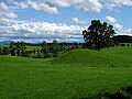
Drumlin area north of Machtlfing
Machtlfinger Bach north of Machtlfing
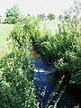
Ascheringer Bach in Aschering

Schwarzer Graben in Traubing
Maisinger See

Fallbach
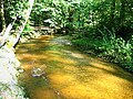
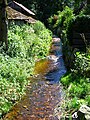
Maisinger Bach in the Maisinger Gorge

Gauge station on the Georgenbach

Weir at the Maisinger Bach

Weir at the Maisinger Bach


Individual evidence
- ↑ a b List of creek and river areas in Bavaria - Isar river area, page 59 of the Bavarian State Office for the Environment, as of 2016 (PDF; 2.5 MB)
- ^ Flood news service Bavarian State Office for the Environment