
Marcillac
| Marcillac | ||
|---|---|---|
|
||
| local community | Val-de-Livenne | |
| region | Nouvelle-Aquitaine | |
| Department | Gironde | |
| Arrondissement | Blaye | |
| Coordinates | 45 ° 16 ′ N , 0 ° 31 ′ W | |
| Post Code | 33860 | |
| Former INSEE code | 33267 | |
| Incorporation | 1st January 2019 | |
| status | Commune déléguée | |
 Former mayor of Marcillac |
||

Marcillac ( Occitan Marcilhac ) is a former municipality with 1,136 inhabitants (as of January 1 2017) in the French department of Gironde in the region Nouvelle-Aquitaine (before 2016: Aquitaine ). It belonged to the Arrondissement of Blaye and the canton of L'Estuaire (until 2015: canton of Saint-Ciers-sur-Gironde ). The inhabitants are called Marcillacois .
On January 1, 2019, Marcillac was merged with Saint-Caprais-de-Blaye to form the Commune nouvelle Val-de-Livenne , based in Saint-Caprais-de-Blaye. Saint-Caprais-de-Blaye and Marcillac have the status of Communes déléguées .
geography
Marcillac is located about 20 kilometers northeast of Blaye and about 50 kilometers north-northeast of Bordeaux in the Blayais area of the historic Guyenne province on the northern border with the neighboring Charente-Maritime department .
Marcillac is surrounded by eight neighboring communities and towns:
|
Boisredon (Charente-Maritime) |
Courpignac (Charente-Maritime) |
Chamouillac (Charente-Maritime) |
|
Saint-Caprais-de-Blaye (Val-de-Livenne) |
.svg)
|
Souméras (Charente-Maritime) |
| Saint-Aubin-de-Blaye | Reignac | Donnezac |
history
The area of Marcillac was inhabited very early. Arranged pebbles that were found east of the hamlet of Les Glorits prove a settlement during the Paleolithic . Evidence from the Gallo-Roman period such as a gray clay pot are also visible in several places. A mosaic stone from a Roman villa has been found east of the town center.
A specialty of Marcillac are its hills. One of these elevations, known as Doues , is located near the hamlet of Les Hauts Ponts. The hill measures eight meters in height and 15 meters in circumference. Investigations at the summit revealed no signs of a structure apart from shards of gray clay pots. It is believed to be the site of a medieval fortress with a wooden tower. According to legend, the mounds were used to transmit signals.
In the hamlet of Reguignon, southeast of the town center, between a manor house and a miller's house, there was probably a castle that was built in the Middle Ages. In the place of its four towers, oaks were once planted, which have now disappeared.
The Livenne river, which flows through the town, supplied a large number of water mills , including the larger mills La Touille, Reguignon, Bretagne and Les Vignolles.
Population development
After records began, the population rose to a peak of around 2,070 by the second half of the 19th century. In the period that followed, the size of the community sank to around 1,000 inhabitants with short recovery phases by the turn of the millennium, before a phase of growth set in, which has recently stagnated again.
| year | 1962 | 1968 | 1975 | 1982 | 1990 | 1999 | 2006 | 2011 | 2017 |
|---|---|---|---|---|---|---|---|---|---|
| Residents | 1,237 | 1,131 | 1,061 | 1,066 | 1,115 | 996 | 1,069 | 1,184 | 1,136 |

Attractions
- Saint-Vincen church from the 12th century, inscribed as a monument historique
- 15th century cemetery cross , classified as a monument historique since 1907
- Reguignon mill from the first half of the 19th century, fulling mill , then grain mill, then flour factory
- Parodier mill from the 18th century, flour mill, then flour factory
- Vignolles mill, flour mill from the end of the 19th century

Saint Vincent Church
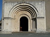
Entrance portal
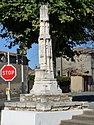
Cemetery cross


literature
- Le Patrimoine des Communes de la Gironde. Flohic Éditions, Volume 2, Paris 2001, ISBN 2-84234-125-2 , pp. 1265-1266.
Web links
Individual evidence
- ↑ RECUEIL DES ACTES ADMINISTRATIFS SPÉCIAL N ° 33-2018-109 ( fr , PDF) Gironde department. Pp. 6-8. October 23, 2018. Retrieved February 12, 2019.
- ^ Marcillac ( fr ) Conseil régional d'Aquitaine. Archived from the original on September 12, 2016. Retrieved February 12, 2019.
- ^ Notice Communale Marcillac ( fr ) EHESS . Retrieved February 12, 2019.
- ↑ Populations légales 2016 Commune de Marcillac (33267) ( fr ) INSEE . Retrieved February 12, 2019.