
Saint-Aubin-de-Blaye
| Saint-Aubin-de-Blaye | ||
|---|---|---|
|
||
| region | Nouvelle-Aquitaine | |
| Department | Gironde | |
| Arrondissement | Blaye | |
| Canton | L'Estuaire | |
| Community association | Estuaire - Canton de Saint-Ciers-sur-Gironde | |
| Coordinates | 45 ° 16 ′ N , 0 ° 34 ′ W | |
| height | 2-37 m | |
| surface | 11.54 km 2 | |
| Residents | 821 (January 1, 2017) | |
| Population density | 71 inhabitants / km 2 | |
| Post Code | 33820 | |
| INSEE code | 33374 | |
| Website | http://www.saint-aubin-de-blaye.fr/index.html | |
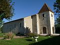
 Town hall (Mairie) of Saint-Aubin-de-Blaye |
||

Saint-Aubin-de-Blaye is a municipality with 821 inhabitants (as of January 1 2017) in the French department of Gironde in the region Nouvelle-Aquitaine . The municipality belongs to the Arrondissement of Blaye and the canton of L'Estuaire (until 2015: canton of Saint-Ciers-sur-Gironde ). The inhabitants are called Saint-Cyriens .
geography
Saint-Aubin-de-Blaye is located on the Livenne River about 57 kilometers north of Bordeaux . Saint-Aubin-de-Blaye is surrounded by the neighboring communities of Val-de-Livenne in the north and east, Reignac in the south-east, Étauliers in the south, Braud-et-Saint-Louis in the west and Saint-Ciers-sur-Gironde in the north-west.
Saint-Aubin-de-Blaye is located on the Via Turonensis of the Camino de Santiago .
Population development
| 1962 | 1968 | 1975 | 1982 | 1990 | 1999 | 2006 | 2017 |
|---|---|---|---|---|---|---|---|
| 645 | 603 | 561 | 605 | 630 | 687 | 733 | 821 |
| Sources: Cassini and INSEE | |||||||
Attractions
- Saint-Aubin church (see also: List of Monuments historiques in Saint-Aubin-de-Blaye )
- Protestant Church
- Mill aa of the Livenne
Saint-Aubin church

Protestant Church


literature
- Le Patrimoine des Communes de la Gironde. Flohic Éditions, Volume 2, Paris 2001, ISBN 2-84234-125-2 , pp. 1270-1271.