
Saint-Androny
| Saint-Androny | ||
|---|---|---|
|
||
| region | Nouvelle-Aquitaine | |
| Department | Gironde | |
| Arrondissement | Blaye | |
| Canton | L'Estuaire | |
| Community association | Estuaire - Canton de Saint-Ciers-sur-Gironde | |
| Coordinates | 45 ° 11 ′ N , 0 ° 39 ′ W | |
| height | 0-36 m | |
| surface | 11.65 km 2 | |
| Residents | 551 (January 1, 2017) | |
| Population density | 47 inhabitants / km 2 | |
| Post Code | 33390 | |
| INSEE code | 33370 | |
_mairie.JPG) Town hall (Mairie) of Saint-Androny |
||

Saint-Androny is a French municipality with 551 inhabitants (as of January 1 2017) in the Gironde department in the region Nouvelle-Aquitaine . The municipality belongs to the Arrondissement Blaye and the canton L'Estuaire (until 2015: canton Blaye ). The inhabitants are called Saint-Andronysia .
geography
Saint-Androny is located on the Gironde estuary , about 39 kilometers north of Bordeaux . Saint-Androny is surrounded by the neighboring communities of Braud-et-Saint-Louis in the north, Anglade in the north and northeast, Eyrans in the east, Fours in the south and southeast, Saint-Genès-de-Blaye in the south (with the Île Bouchaud ), Saint-Julien-Beychevelle in the southwest and Pauillac in the west (on the other side of the estuary).
Population development
| 1962 | 1968 | 1975 | 1982 | 1990 | 1999 | 2006 | 2017 |
|---|---|---|---|---|---|---|---|
| 587 | 562 | 442 | 584 | 547 | 566 | 570 | 551 |
| Sources: Cassini and INSEE | |||||||
Attractions
- Saint-Androny church, largely from the 19th century
- Patiras lighthouse
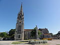
Saint-Androny church

Patiras lighthouse
_%C3%A9glise,_ext%C3%A9rieur.JPG)

literature
- Le Patrimoine des Communes de la Gironde. Flohic Éditions, Volume 1, Paris 2001, ISBN 2-84234-125-2 , p. 232.