
Pugnac
| Pugnac | ||
|---|---|---|
.svg)
|
|
|
| region | Nouvelle-Aquitaine | |
| Department | Gironde | |
| Arrondissement | Blaye | |
| Canton | L'Estuaire | |
| Community association | Grand Cubzaguais | |
| Coordinates | 45 ° 5 ′ N , 0 ° 30 ′ W | |
| height | 3–52 m | |
| surface | 13.53 km 2 | |
| Residents | 2,288 (January 1, 2017) | |
| Population density | 169 inhabitants / km 2 | |
| Post Code | 33710 | |
| INSEE code | 33341 | |
| Website | http://pugnac.fr/ | |
 Town hall (Mairie) and memorial to the dead of wars in Pugnac |
||

Pugnac ( Occitan : identical) is a town in southwestern France and a municipality with 2,288 inhabitants (as of January 1, 2017) in the Gironde department in the north of the Aquitaine region . The municipality belongs to the Arrondissement Blaye and the canton L'Estuaire (until 2015: canton Bourg ). The inhabitants are called Pugnacais .
location
Pugnac is located about 27 kilometers north-northeast of Bordeaux in the historic province of Angoumois in the Charente cultural landscape . Pugnac is surrounded by the neighboring communities of Saint-Vivien-de-Blaye in the north, Civrac-de-Blaye in the northeast, Cézac in the east, Tauriac in the south, Lansac in the southwest, Mombrier in the west and Teuillac in the northwest.
Population development
| year | 1962 | 1968 | 1975 | 1982 | 1990 | 1999 | 2006 | 2017 |
| Residents | 784 | 820 | 1120 | 1610 | 1875 | 1893 | 1957 | 2288 |
| Sources: Cassini and INSEE | ||||||||
Attractions
- Church of Saint-Sulpice in Lafosse from the 11th / 12th centuries Century, Monument historique
- Notre-Dame Church, built in 1861
- Saint-Urbain Chapel

Saint-Sulpice church
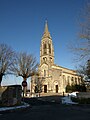
Notre-Dame church

Saint-Urbain Chapel


Parish partnership
There is a partnership with the French commune of Saint-Mamet-la-Salvetat in the Cantal department (Auvergne region).
literature
- Le Patrimoine des Communes de la Gironde. Flohic Éditions, Volume 1, Paris 2001, ISBN 2-84234-125-2 , pp. 361-363.