
Maximilian Grotto
| Maximilian Grotto
|
||
|---|---|---|
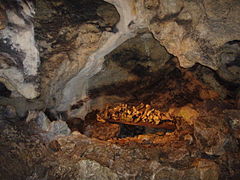
 The iceberg |
||
| Location: | Franconian Switzerland , Germany | |
|
Geographic location: |
49 ° 37 '43 " N , 11 ° 35' 18" E | |
|
||
| Cadastral number: | A 27 | |
| Type: | Stalactite cave | |
| Discovery: | 1596 (first written mention) | |
| Show cave since: | 1878 | |
| Lighting: | electric | |
| Overall length: | 1,200 meters | |
| Length of the show cave area: |
400 meters | |
| Average annual number of visitors: | 9,900 (2007-2011) | |
| Current visitors: | 9,300 (2011) | |
| Website: | Site of the cave keeper | |

The Maximiliansgrotte is a show cave near Krottensee , a district of Neuhaus an der Pegnitz in the Middle Franconian district of Nürnberger Land in Bavaria .
location
The karst cave is located in the Franconian Switzerland-Veldenstein Forest Nature Park about 2.6 kilometers east of Neuhaus an der Pegnitz.
description
The stalactite cave in the Krottenseer Forest is part of the Jurahöhle adventure world . Its total length is 1.2 kilometers, the greatest height is 70 meters. Their lowest point is 70 meters below the surface of the earth. The grotto consists of a branched system of corridors with smaller and larger halls on several floors. The public tours, for which an artificial entrance and exit was created, only cover part of the cave.
The Maximiliansgrotte is registered as A 27 in the Franconian Alb cave register (HFA). The cave is designated by the Bavarian State Office for the Environment as geotope 371H001 and a natural monument .
The halls were given names to remind of their shape. There is an “organ grotto” and a “treasure chamber”. A six meter high stalactite, the so-called iceberg, is the largest stalactite in Germany. Since the grotto has several entrances, clear air movements can be perceived as a result of the dynamic ventilation at the entrances. That is why it used to be called Windloch.
history
It is possible that the Maximiliansgrotte was created as early as the Cretaceous period . Leach facets prove that the cave below the karst water table was formed by still water. It is not certain whether the grotto was once inhabited by people. Shards of a vessel from the Hallstatt period that were found inside were probably just washed into it.
The cave was first mentioned in writing in 1596, when Elector Friedrich IV of the Palatinate tried to turn the stalactites into gold . At that time he had “yellow matter” (in truth it was cave clay) and chipped stalactites removed from the cave.
During the Thirty Years' War the farmers from the area hid their wives and daughters in the Maximiliansgrotte. In 1703 28 fallen soldiers were thrown into the cave during the War of the Spanish Succession ; In 1833 a mentally confused woman from the area fell through the so-called wind hole, the only known entrance at the time, and was only found unharmed in the cave after five days.
For a long time it was argued whether the cave belongs to Upper Palatinate or Middle Franconia. Due to their location on the border, Auerbach and Neuhaus an der Pegnitz raised claims to the cave. In 2003 the state decided that the Middle Franconia cave belongs to it.
exploration
The current entrance has only been used since 1852. On New Year's Eve 1852, three men from the area explored the cave more closely for the first time. Among them was Johann Leißner from Krottensee, after whom one of the halls of the cave is named.
In memory of Maximilian II , the cave was renamed Maximiliansgrotte in 1853 or 1854. It has been open to the public since 1878. In 1994 the carbide lamps , the soot of which had blackened many stalactites, were replaced by electric light. The cave is visited by around 10,000 guests annually. Compared to what is probably the most famous cave in Franconian Switzerland , the Teufelshöhle with 156,100 visitors in the five-year average from 2006 to 2010, the number is relatively low.
The visit is only possible as part of a guided tour and is limited to a very small part of the cave. It begins at the entrance that has been in use since 1852. The first hall to be visited is the Leißnerdom. From here you can see daylight falling through the wind hole at a height of 26 meters above the cave floor. Behind the Leißnerdom lies the eagle grotto, which was named after a stalactite formation that resembles an eagle with outstretched wings. In addition to the eagle, there is also an owl, a small elephant and an udder.
In the organ grotto, the next room, there are numerous stalactites , some of which have grown on fallen blocks. At least on one of these blocks remains of stalagmites can be seen, which are inclined, from which one can draw conclusions about the original position. The approximately six meter high iceberg with a diameter of approximately three meters is located in a side grotto of the organ grotto. At the end of the organ grotto you can see the so-called baptismal font, a sintered basin with a diameter of about 50 centimeters.
The path through the treasury follows; In a side grotto there is a dripstone group in the form of an elephant with a rider. After passing some stalactite pillars, one arrives at the Black Hall, in which the remains of cave bears found in the cave and the bones of soldiers who died in the War of the Spanish Succession were collected. From there you can get outside through an exit discovered in 1926; presumably this was also the way on which the cave bears once reached the Maximiliansgrotte. Nearby is the wind hole secured by a grid and a fence above the Leißner Cathedral.
Picture gallery
Bones from fallen soldiers (below) and from cave bears (above)

The owl

Treasury
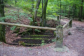
The wind hole

The entrance

The exit


literature
- Richard G. Spöcker: The Maximiliansgrotte near Krottensee, self-published, Nuremberg 1926
- Department of Karst and Speleology of the Natural History Society V. (Hrsg.): The Maximiliansgrotte near Krottensee and the karst hiking trail . 2002.
- Hans Binder, Anke Luz, Hans Martin Luz: Show caves in Germany . Aegis Verlag, Ulm 1993, ISBN 3-87005-040-3 , pp. 72-73.
Web links
Individual evidence
- ↑ Location of the cave in the Bavaria Atlas (accessed on September 24, 2016)
- ↑ Geotope: Maximiliansgrotte (show cave) (accessed on March 20, 2020)
- ↑ Private homepage, Maximiliansgrotte (accessed on September 24, 2016)