
Easter cave
| Easter cave
|
||
|---|---|---|
 |
||
| Location: | Franconian Switzerland , Germany | |
| Height : | 497 m above sea level NN | |
|
Geographic location: |
49 ° 31 '9 " N , 11 ° 39' 46.5" E | |
|
||
| Cadastral number: | A 94 | |
| Type: | Stalactite cave | |
| Show cave since: | 1905 | |
| Lighting: | flashlight | |
| Overall length: | 185 meters | |
| Length of the show cave area: |
130 meters | |
| Website: | osterhoehle.net | |

The Osterhöhle is a small show cave near Trondorf, a district of the Upper Palatinate community of Neukirchen near Sulzbach-Rosenberg in the Amberg-Sulzbach district in Bavaria.
history
The 185 meter long cave can be visited on the weekends during the summer months. The first documentary mention was around 1630. Today's entrance was artificially created in 1905 to open it to visitors as a show cave. In 1935 it was expanded in its current form. As one of the last caves in Germany, the Easter cave was illuminated with carbide lamps for a long time . Currently, visitors are given flashlights on guided tours . Relatively high concentrations of manganese were found on the walls . The origin of the name Osterhöhle is not clear, it probably comes from the location of the cave on the Osterberg, the name of which may be associated with the Germanic goddess of the rising light, Ostara.
In the cave register Fränkische Alb (HFA) the Osterhöhle is listed as A 94 and is designated by the Bavarian State Office for the Environment as geotope 371H002. Due to finds from the late Hallstatt / early La Tène period and the late Middle Ages , it is also designated as a ground monument (D-3-6435-0106).
description
Immediately at the entrance to the locked cave is a managed hut. The karst cave lies in the little banked Franconian dolomite and is an extensive passage system with dome-like extensions. In the cave there are rich sintering , stalactites and some sintering basins. The cave is essentially divided into three parts. After descending (about 16 meters) from the entrance via a staircase, you get to the hall-like so-called cathedral. In addition to Verbruch, ceiling ponds and wall sinter, which got its predominantly dark color from earlier tours with open light, dominate there. In the meantime, the wall decoration is covered in white sintered limestone in many places and leads to an impressive play of colors and shapes.
The “water hall” adjoins it in the northeastern direction of the cathedral. There is a small lake up to half a meter deep. Further north are unadorned corridors filled with sediment (clay).
Southeast of the cathedral leads to the "church" with numerous stalagmites , stalactites and a remarkable stalagnates . The crime has hibernated there.

Hut and entrance

entrance
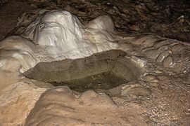
Sinter basin

Cave lake
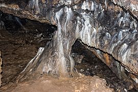
Stalagnate in the church

Wall sinter


See also
literature
- Fritz Huber: The northern Franconian Alb, Volume 2, The caves of the karst area A Königstein .
- Richard Spöcker : Topographical Cave Atlas of Franconia, 1930 .
- Hans Binder, Anke Luz, Hans Martin Luz: Show caves in Germany . Aegis Verlag, Ulm 1993, ISBN 3-87005-040-3 , pp. 80-81.
Individual evidence
- ↑ Geotope: Osterhöhle near Trondorf (show cave) (accessed on August 25, 2013; PDF; 186 kB)
- ↑ List of architectural and ground monuments in Neukirchen near Sulzbach-Rosenberg (accessed on May 15, 2016)
Web links
- Webpage of the Osterhöhle (accessed on March 12, 2013)
- Easter cave at Lochstein.de
- Showcaves: Easter cave
- The Easter cave in Neukirchen