
Mercury (mountain)
| Mercury | ||
|---|---|---|
 View from Fremersberg over Baden-Baden to Merkur |
||
| height | 669 m above sea level NHN | |
| location | Baden-Wuerttemberg , Germany | |
| Mountains | Black Forest | |
| Coordinates | 48 ° 45 '52 " N , 8 ° 16' 50" E | |
|
||

Merkur or Großer Staufenberg is 669 m above sea level. NHN high mountain in the northern Black Forest on the boundary of the cities of Baden-Baden and Gernsbach . The local mountain of Baden-Baden is from there by funicular opened up and the site of a lookout and transmission tower .
Surname
The mountain is named after the ancient Roman god of trade and commerce Mercurius , to whom a Roman votive stone found on the summit is dedicated. The Merkurstein has been attested since the 16th century. A cast of the consecration stone can be viewed on the summit plateau today; the original is in the city history collections . The original name of the free-standing mountain cone is Großer Staufenberg , an allusion to the shape of an upturned drinking cup ( Stauf ) .
geology
Mercury and the neighboring Kleine Staufenberg ( 623.4 m ) to the south are made up of several layers of sedimentary rocks . Ascending from the urban area of Baden-Baden, one finds 251 to 299 million year old deposits or conglomerates from the Rotliegend . Since the larger stones enclosed in it are volcanic rocks ( quartz porphyry ), the rocks were given the technical term porphyry conglomerate . Above the Rotliegend one finds red sandstone , initially lower red sandstone and in higher layers middle red sandstone . These rocks are 244 to 251 million years old.
In the many millions of years up to around 60 million years ago, many more layers of rock were deposited. For 60 million years the Black Forest has been rising and the rift valley of the Rhine plain has been sinking . Since then, the layers of rock above the Middle Buntsandstein have been eroded away again. The erosion formed the valleys around Mercury and the mountain itself, which was preserved as a witness mountain .
With the formation of the Black Forest, many faults formed along the edge of the ditch. There are several columns in and around Baden-Baden. One of these crevices runs from Baden-Baden into the Murgtal between Merkur and Battert . She is responsible for the natural hot thermal springs of Baden-Baden. It is so deep and wide underground that large masses of water can circulate in it and thus transport the heat from the earth's interior to the earth's surface.
East of the Kleiner Staufenberg there are 318 to 299 million year old rocks of the Upper Carboniferous . Coal seams are often found in this layer . A prospecting for uranium was carried out in Müllenbach . The proven uranium deposits are 3000 t, the uranium content is only 0.2%, so that mining is not economical.
Further southeast of Müllenbach you finally come across the foothills of the basement made of solid granite .
cable railway

The Merkurgipfel can only be reached by visitors on foot, by bike or from Baden-Baden with the Merkurbergbahn . Built in 1913, the mountain railway was shut down in 1967 for technical reasons and reopened in 1979. 1200 meters long, one of the longest funiculars in Germany overcomes an incline of up to 54%, which gives a view of Baden-Baden even during the train journey.
Observation tower

At the highest point of the mountain is since 1837 at 48 ° 45 ' "52 N , 50 8 ° 16'" O an observation tower , the Mercury tower . It was increased when the mountain railway was built and has also served as a radio transmitter since the 1950s. A 63-meter-high antenna support made of tubular steel stands on a younger reinforced concrete extension.
The mountain offers a panoramic view not only over the basin of Baden-Baden, the highest mountains in the northern Black Forest and the Murg Valley with the cities of Gaggenau and Gernsbach , but also as far as the Upper Rhine Plain , to the Vosges , Haardt and Odenwald . In the field of vision are the Hohenbaden ruins , the Battertfelsen , the Alt-Eberstein ruins , the Fremersberg , the Yburg , the Badener Höhe and the Hornisgrinde as well as the cities of Karlsruhe and Strasbourg .
Other attractions
There is a restaurant at the mountain station. A sunbathing lawn, a barbecue area and a playground with a giant slide have also been set up on the summit. So-called terrain spa trails of different lengths and gradients have been created for spa purposes. One of these paths leads to the game reserve at the foot of the mountain, where red, fallow and mouflon deer live. The premium hiking trail Panoramaweg leads along the Merkur at half-height on the Baden-Baden side . The Merkurgipfel is a station on the premium hiking trails Gernsbacher Runde and Murgleiter .
On the top of the mountain there are two launch sites for paragliders , one in a westerly direction directly at the mountain station of the Merkurbergbahn, the other in a northeastern direction. Landing areas are meadows below the valley station of the mountain railway in Baden-Baden and above Gernsbach-Staufenberg at the Neuhaus bus stop .
In 2012 the geological nature trail Merkurs Würfel opened at the summit , presenting various types of rock in the Baden-Baden region.
Large rhododendron bushes grow at the valley station, along the railway line and at the mountain station . They were planted under Walter Rieger, Baden-Baden's horticultural director in the 1950s and 1960s.
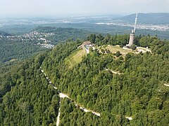
Aerial view from Merkur with a view of the Murg valley
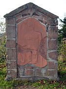
Votive stone of the god Mercurius

Mountain station of the railway with restaurant

Paraglider over Baden-Baden

Geological nature trail

Rhododendron blossom at the summit of Mercury


.jpg)
Web links
Individual evidence
- ↑ Map services of the Federal Agency for Nature Conservation ( information )
- ^ Art and cultural monuments in the Rastatt district and in Baden-Baden , published by the Rastatt district and the city of Baden-Baden. Konrad-Theiss Verlag GmbH, Stuttgart 2002, ISBN 3-8062-1599-5 , p. 92
- ↑ Merkurs Würfel - a geological journey through time - Industrieverband Steine und Erden Baden-Württemberg eV, accessed on April 1, 2014
- ↑ Wolfgang Kohler: Mercury's Cube - or the return to a unique geology. In: Arbeitskreis für Stadtgeschichte Baden-Baden eV (Ed.): Aquae 2012, ISSN 0175-4858 pp. 10-25.
- ^ Bernd Weigel: Park Guide Baden-Baden . Ed .: Baden-Baden city administration, garden department. 2001, p. 84, 112 .