
Milwaukee River
| Milwaukee River | ||
 Milwaukee River catchment area |
||
| Data | ||
| Water code | US : 1569543 | |
| location | Wisconsin (USA) | |
| River system | Saint Lawrence River | |
| Drain over | St. Clair River → Detroit River → Niagara River → Saint Lawrence River → Atlantic Ocean | |
| source | in the Fond du Lac County 43 ° 42 ′ 19 ″ N , 88 ° 17 ′ 18 ″ W |
|
| muzzle | in Milwaukee in Lake Michigan Coordinates: 43 ° 1 '32 " N , 87 ° 54' 10" W 43 ° 1 '32 " N , 87 ° 54' 10" W. |
|
| Mouth height |
176 m
|
|
| length | 121 km | |
| Catchment area | 2300 km² | |
| Right tributaries | Cedar Creek , Menomonee River , Kinnickinnic River | |
| Big cities | Milwaukee | |
| Medium-sized cities | West Bend | |
 Milwaukee River in Milwaukee |
||
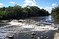
The Milwaukee River is an approximately 121 km long river in the state of Wisconsin .
The river has its source in Fond du Lac County and flows past Grafton into downtown Milwaukee , where it flows into Lake Michigan . Cedar Creek , Menomonee River, and Kinnickinnic River are the major tributaries.
Catchment area
The Milwaukee River drains more than 2,300 km² in southeast Wisconsin. It belongs to the catchment area of Lake Michigan, which drains into the Atlantic via the St. Lawrence River.
The catchment area includes portions of Dodge , Fond du Lac , Milwaukee , Ozaukee , Sheboygan , Washington, and Waukesha counties .
history
The Milwaukee River area was inhabited by Indians before European settlement . Jacques Marquette and Louis Jolliet drove from Lake Michigan through the Milwaukee River on their way to the Fox River and the Mississippi River .
At the beginning of the 19th century, three towns were founded on the banks of the Milwaukee and Kinnickinnic Rivers: Juneautown by Solomon Juneau , Walker's Point by George H. Walker and Kilbourntown by Byron Kilbourn . The dispute over the construction of a bridge over the Milwaukee River was one of the triggers for the merger of the three cities to form the City of Milwaukee in 1846 .
photos

shortly before the confluence with Lake Michigan

