Mineola (New York)
| Mineola | |
|---|---|
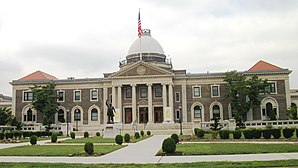
 Old Nassau County Court House |
|
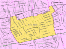
| Location of the county in New York and location of the village in the county | |
| Basic data | |
| State : | United States |
| State : | new York |
| County : | Nassau County |
| Coordinates : | 40 ° 45 ′ N , 73 ° 38 ′ W |
| Residents : | 19,234 (as of 2010) |
| Population density : | 3,925.3 inhabitants per km 2 |
| Area : | 4.9 km 2 (approx. 2 mi 2 ) of which 4.9 km 2 (approx. 2 mi 2 ) are land |
| Postal code : | 11501 |
| Area code : | +1 516 |
| FIPS : | 36-47636 |
| GNIS ID : | 0957391 |
Mineola is a village and county seat of Nassau County on Long Island . It belongs to Town North Hempstead . To the south, Garden City joins in Hempstead .
geography
Mineolas geographical coordinates are 40 ° 45 ' N , 73 ° 38' W .
According to the United States Census Bureau , the Village has a total area of 4.9 km 2 , all of which is land, with the Village adding areas between the 1990 Census and the 2000 Census.
Mineola is adjacent to Villages Garden City , Old Westbury , East Williston, and Williston Park . Mineola is also adjacent to Census-designated places Herricks , Garden City Park, and Carle Place .
Roosevelt Field
During the First World War, near Mineola in what is now Garden City in Hempstead, a military airport was built, which was renamed Roosevelt Field in 1919 after President Theodore Roosevelt's son , Quentin Roosevelt , who died in the war . Here Charles Lindbergh started his flight across the Atlantic in 1927. The airport, which was closed in 1951, also served as a landing pad for airships .
Sons and daughters of Mineola
- Donald Bain (1935-2017), writer
- Martin Bäumer (* 1967), politician
- Lenny Bruce (1925–1966), stand-up comedian and satirist
- Emmy Clarke (born 1991), actress
- Justine Cotsonas (born 1985), actress
- Louis Gerstner, Jr. (born 1942), entrepreneur
- Kevin James (born 1965), actor
- Marie C. Jerge (* 195x), Lutheran bishop
- James Patrick Kelly (born 1951), science fiction writer
- Carlos Mendes (* 1980), football player
- Sally Menke (1953–2010), film editor and film producer
- John F. Murray (1927-2020), medical professional
- John Barry Nusum (born 1981), football player
- Gregory Lawrence Parkes (* 1964), Catholic Bishop of Saint Petersburg
- Stephen Parkes (* 1965), Roman Catholic clergyman and Bishop of Savannah
- Susan Rose-Ackerman (* 1942), economist
- Robert B. Silvers (1929–2017), Associate Editor of the New York Review of Books
- Gerry Studds (1937-2006), politician
- Alexa Vojvodić (* 1992), soccer player
Web links
Individual evidence
- ^ New York: 2000 Population and Housing Unit Counts . September 2003. Retrieved December 22, 2010.

