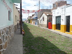
Municipio Villa Corona
| Villa Corona | |
|---|---|

|
|
| Basic data | |
| Country | Mexico |
| State | Jalisco |
| Seat | Villa Corona |
| surface | 319.1 km² |
| Residents | 16,969 (2010) |
| density | 53.2 inhabitants per km² |
| founding | 1918 |
| INEGI no. | 14114 |
| politics | |
| Presidente municipal | José de Jesús Uribe López |
| Estipac | |
Coordinates: 20 ° 24 ′ N , 103 ° 40 ′ W
Villa Corona is a municipality in the Mexican state of Jalisco in the Región Centro . The municipality had 16,969 inhabitants at the 2010 census; the area of the municipality is 319.1 km².
The largest place in the municipality and administrative seat is the Villa Corona of the same name ( called Tizapanito until 1918 ). Other places with at least 1000 inhabitants are Estipac , Atotonilco el Bajo and Juan Gil Preciado . The municipality comprises a total of 25 localities.
The Municipio Villa Corona borders the Municipios Cocula , San Martín Hidalgo , Tala , Acatlán de Jurárez , Zacoalco de Torres and Atemajac de Brizuela .
Most of the municipality is at an altitude of 900 m to 1500 m , in the south the highest peaks reach a height of 2400 m . About 40% of the community area is forested or used for agriculture. The Laguna de Atotonilco forms a tenth of the area .
Web links
- Enciclopedia de los Municipios y Delegaciones de México: Municipio Villa Corona (Spanish)
- INEGI : Datos Geográficos: Municipio Villa Corona (Spanish; PDF)
- jalisco.gob.mx: Villa Corona (Spanish)

