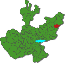
Municipio Unión de San Antonio
| Unión de San Antonio | ||
|---|---|---|

|
||
| Symbols | ||
|
||
| Basic data | ||
| Country | Mexico | |
| State | Jalisco | |
| Seat | Unión de San Antonio | |
| surface | 730.7 km² | |
| Residents | 17,325 (2010) | |
| density | 23.7 inhabitants per km² | |
| founding | before 1835 | |
| Website | uniondesanantonio.gob.mx | |
| INEGI no. | 14109 | |
| politics | ||
| Presidente municipal | José de Jesús Hurtado Torres | |
Coordinates: 21 ° 8 ′ N , 102 ° 0 ′ W
Unión de San Antonio is a municipality in the Mexican state of Jalisco in the Región Altos Norte . The municipality had 17,325 inhabitants at the 2010 census; the area of the municipality is 730.7 km².
The largest place in the municipality and administrative seat is the Unión de San Antonio of the same name . Other places with at least 1000 inhabitants are Tlacuitapan and San José del Caliche . The municipality comprises a total of 144 localities.
The Municipio Unión de San Antonio borders the Municipios San Juan de los Lagos , Lagos de Moreno , San Diego de Alejandría and San Julián, as well as the state of Guanajuato .
Most of the municipality is at an altitude of 1800 m to 2200 m . About 45% of the community area is used for agriculture, 35% of the area is pasture land, 17% is forested.
Web links
- Enciclopedia de los Municipios y Delegaciones de México: Municipio Unión de San Antonio (Spanish)
- INEGI : Datos Geográficos: Municipio Unión de San Antonio (Spanish; PDF)
- jalisco.gob.mx: Unión de San Antonio (Spanish)

