Municipio Zapopan
| Zapopan | ||
|---|---|---|

|
||
| Symbols | ||
|
||
| Basic data | ||
| Country | Mexico | |
| State | Jalisco | |
| Seat | Zapopan | |
| surface | 1,166.1 km² | |
| Residents | 1,243,756 (2010) | |
| density | 1,066.6 inhabitants per km² | |
| founding | 1824 | |
| Website | www.zapopan.gob.mx/ | |
| INEGI no. | 14120 | |
| politics | ||
| Presidente municipal | Héctor Robles Peiro | |
| Palacio Municipal | ||
Coordinates: 20 ° 43 ′ N , 103 ° 24 ′ W
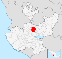
Zapopan is a municipality in the Mexican state Jalisco in the Región Centro . The municipality - it forms the north of the Zona Metropolitana de Guadalajara - had 1,243,756 inhabitants in the 2010 census; the area of the municipality is 1166.1 km².
The largest city in the municipality and administrative seat is the metropolis of the same name, Zapopan . Other places with at least 4000 inhabitants are Tesistán , La Venta del Astillero , Fraccionamiento Campestre Las Palomas and Nextipac . The municipality comprises a total of 234 localities.
The Municipio Zapopan borders the Municipios Tequila , San Cristóbal de la Barranca , Ixtlahuacán del Río , Guadalajara , Tlajomulco de Zúñiga , Tala , El Arenal and Amatitán .
The municipal area is on average around 1550 m above sea level, the predominant landscape is hilly between 1500 m and 2000 m altitude. A good 40% of the community area is forested, over 20% is used for agriculture, 9% form the urban zone in the metropolitan region.
Web links
- Enciclopedia de los Municipios y Delegaciones de México: Municipio Zapopan (Spanish)
- INEGI : Datos Geográficos: Municipio Zapopan (Spanish; PDF)
- jalisco.gob.mx: Zapopan (Spanish)


