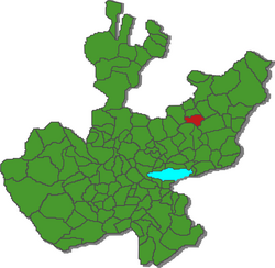
Municipio Valle de Guadalupe
| Valle de Guadalupe | |
|---|---|

|
|
| Basic data | |
| Country | Mexico |
| State | Jalisco |
| Seat | Valle de Guadalupe |
| surface | 353.2 km² |
| Residents | 6705 (2010) |
| density | 19 inhabitants per km² |
| founding | 1922 |
| Website | valledeguadalupe.gob.mx/ |
| INEGI no. | 14111 |
| politics | |
| Presidente municipal | Álvaro Ibarra Padilla |
| Plaza Principal | |
Coordinates: 21 ° 0 ′ N , 102 ° 37 ′ W
Valle de Guadalupe is a municipality in the Mexican state of Jalisco in the Altos Sur region . The municipality had 6,705 inhabitants at the 2010 census; the area of the municipality is 353.2 km².
The largest place in the municipality and administrative seat is the Valle de Guadalupe of the same name . Four other places have at least 100 inhabitants: La Providencia , Puerta de Macías , Cañada Grande and El Rosario . The municipality comprises a total of 86 localities.
The municipality of San Gabriel is bordered by the municipalities of Cañadas de Obregón , Jalostotitlán , San Miguel el Alto , Tepatitlán de Morelos and Yahualica de González Gallo .
The municipality is at an average altitude of around 1800 m . Around a third of the municipal area is forested or used for agriculture. 23% are pastures.
Web links
- Enciclopedia de los Municipios y Delegaciones de México: Municipio Valle de Guadalupe (Spanish)
- INEGI : Datos Geográficos: Municipio Valle de Guadalupe (Spanish; PDF)
- jalisco.gob.mx: Valle de Guadalupe (Spanish)

