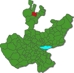
Municipio Villa Guerrero (Jalisco)
| Villa Guerrero | ||
|---|---|---|

|
||
| Symbols | ||
|
||
| Basic data | ||
| Country | Mexico | |
| State | Jalisco | |
| Seat | Villa Guerrero | |
| surface | 675 km² | |
| Residents | 5638 (2010) | |
| density | 8.35 inhabitants per km² | |
| founding | 1921 | |
| INEGI no. | 14115 | |
| politics | ||
| Presidente municipal | Rodolfo Rivas Valdés | |
| Villa Guerrero | ||
Coordinates: 21 ° 59 ′ N , 103 ° 36 ′ W
Villa Guerrero is a municipality in the Mexican state of Jalisco in the Región Norte . The municipality had 5,638 inhabitants at the 2010 census; the area of the municipality is 675 km².
The only place in the municipality with at least 500 inhabitants and an administrative seat is the Villa Guerrero of the same name ( called El Salitre until 1921 ). The municipality comprises a total of 61 localities.
The Municipio Villa Guerrero borders the Municipios Totatiche , Mezquitic , Chimaltitán and Bolaños as well as the Municipio Monte Escobedo in the state of Zacatecas .
The municipal area is at an altitude of 900 m to 2100 m . More than two thirds of the community area is forested, 14% is pasture and another 10% is used for agriculture.
Web links
- Enciclopedia de los Municipios y Delegaciones de México: Municipio Villa Guerrero (Spanish)
- INEGI : Datos Geográficos: Municipio Villa Guerrero (Spanish; PDF)
- jalisco.gob.mx: Villa Guerrero (Spanish)


