Great Dhünntalsperre nature reserve (Great and Small Dhünn)
|
Great Dhünntalsperre nature reserve (Great and Small Dhünn)
|
||
|
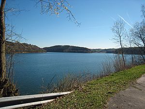
View from the dam, on the left Wermelskirchen area, |
||
| location | Odenthal and Wermelskirchen , North Rhine-Westphalia , Germany | |
| surface | 680.00 | |
| Identifier | GL-023 | |
| WDPA ID | 163339 | |
| Geographical location | 51 ° 4 ' N , 7 ° 11' E | |
|
|
||
| Setup date | 1992 | |
| Framework plan | Landscape plan Great Dhünntalsperre | |
| administration | Lower landscape authority Rheinisch-Bergischer Kreis | |
The nature reserve Große Dhuenntalsperre (Große and Kleine Dhünn) is a nature reserve in the areas west and north of the Große Dhünntalsperre in the area of the municipality of Odenthal and the town of Wermelskirchen in the Rheinisch-Bergisch district .
description
Odenthal
The protected area in the municipality of Odenthal extends from the dam wall to the storage basin west of Richerzhagen . Biotopes worthy of protection BK-4909-0186 The area is often planted with old, sometimes also with young beech forests . Numerous source brooks flow to the valley on the slopes, which often flow into reservoirs with bank areas that are livened up by reed beds . The southern extension of the area is usually marked by a forest-open land border . The biotope is particularly representative of the Bergische plateau due to its relative unspoilt nature as a result of the water protection area situation and the associated special duty of care with regard to possible impairments for the adjacent water body of the dam. The area forms a functional unit with the water body of the Great Dhünn Dam. The hillside forests take on an important soil protection function for the dam. The main development goal is the preservation and optimization of the beech forest areas and the gradual elimination of the adjacent coniferous forests, which are to be replaced by new beech trees.
Wermelskirchen
The protected area in the city of Wermelskirchen extends from the dam in Lindscheid in the west to the Neumühle car park in the east. Deserving Protection habitats BK-4909-0187 and BK-4909-901 On the shore slopes prevail above the waterline broom - or broom Gentiles -Gewächse ago, where hang Windwärts to Birken - pioneer forests and forest strip of Book and - oak -Forest or spruce forests connect. The beech-oak forests are easy to recognize by the undergrowth of bracken , holly and the common goldenrod . There are also pines or occasional larches and sessile oaks . In the birch-oak forests, blueberries grow in the herb layer together with pipe-grass and wire-smiths . The birch pioneer forests also penetrate heavily into the heaths and overgrow them. At the steeper points of the embankments that almost completely surround the reservoir, dry grass-like fescue sheep have developed on the farm roads above the high water mark . These partly sandy, loamy and often stony slopes offer suitable habitats for reptiles but also for numerous insects. Various small streams flow into the dam. Most of the time the vegetation on the slopes is rather sparse, as the banks are for the most part very steep. A large fallow orchard is located on a slope in the area of the former farm in Sondern, east of Lindscheid . It has numerous fruit trees of different ages, including lying dead wood. While tall herbaceous vegetation and blackberry bushes predominate in the lower area, the areas on the upper slope are more open and overgrown with grasses and herbs.
Protection goals
Nature conservation was decided to preserve communities or habitats of certain wild plants and animal species. This included scientific, natural history, geographical and geological backgrounds due to the rarity, the special character and outstanding beauty of the area. For this purpose, near-natural forest communities in the area of forest communities, in the area of the dam and on the valley slopes, as well as grasslands and orchards are to be preserved and further developed. Ultimately, it is about the preservation and networking of near-natural habitats in the bottom and notch valleys, including the streams and the slope areas, to form a biotope network.
See also
- Töckelhausener Bachtal nature reserve
- Great Dhünntalsperre nature reserve (south)
- List of nature reserves in the Rheinisch-Bergisches Kreis
Individual evidence
- ↑ a b c d e f nature reserve "Große Dhuenntalsperre (Große and Kleine Dhünn)" in the specialist information system of the State Office for Nature, Environment and Consumer Protection of North Rhine-Westphalia , accessed on April 27, 2017.


