John Day River
| John Day River | ||
| Data | ||
| Water code | US : 1144304 | |
| location | Oregon (USA) | |
| River system | Columbia River | |
| Drain over | Columbia River → Pacific Ocean | |
| source |
Strawberry Mountains , Malheur National Forest 44 ° 14 ′ 44 ″ N , 118 ° 33 ′ 8 ″ W |
|
| Source height | 2743 m | |
| muzzle |
Columbia River Coordinates: 45 ° 43 ′ 57 " N , 120 ° 38 ′ 57" W 45 ° 43 ′ 57 " N , 120 ° 38 ′ 57" W. |
|
| Mouth height | 82 m | |
| Height difference | 2661 m | |
| Bottom slope | 5.9 ‰ | |
| length | 452 km | |
| Catchment area | 20,720 km² | |
| Discharge at the McDonald Ferry gauge. Location: 34 km above the mouth |
MNQ MQ MHQ |
0 l / s 58 m³ / s 1116 m³ / s |
| Left tributaries | South Fork John Day River | |
| Right tributaries | North Fork John Day River , Rock Creek | |
| National Wild and Scenic River | ||
|
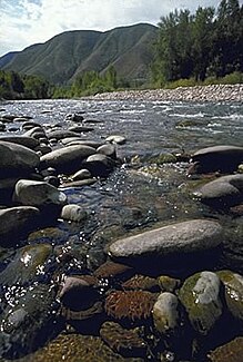
John Day River at Clarno |
||
| Middle Fork John Day River | ||
| Data | ||
| Water code | US : 1146148 | |
| location | Oregon (USA) | |
| River system | Columbia River | |
| Drain over | North Fork John Day River → John Day River → Columbia River → Pacific Ocean | |
| source | in the Blue Mountains in Grant County 44 ° 35 ′ 5 " N , 118 ° 25 ′ 48" W. |
|
| Source height | 1297 m | |
| muzzle |
North Fork John Day River 44 ° 54 ′ 59 ″ N , 119 ° 18 ′ 8 ″ W. |
|
| Mouth height | 670 m | |
| Height difference | 627 m | |
| Bottom slope | 5.3 ‰ | |
| length | 118 km | |
| Catchment area | 2088 km² | |
| Discharge at the Ritter gauge. Location: 24 km above the mouth |
MNQ MQ MHQ |
30 l / s 7.28 m³ / s 133.94 m³ / s |
| North Fork John Day River | ||
|
North Fork John Day River in the North Fork John Day Wilderness |
||
| Data | ||
| Water code | US : 1146969 | |
| location | Oregon (USA) | |
| River system | Columbia River | |
| Drain over | John Day River → Columbia River → Pacific Ocean | |
| source | in the Blue Mountains in Grant County 44 ° 51 '48 " N , 118 ° 14' 13" W |
|
| Source height | 2276 m | |
| muzzle |
John Day River 44 ° 45 ′ 22 ″ N , 119 ° 38 ′ 19 ″ W. |
|
| Mouth height | 559 m | |
| Height difference | 1717 m | |
| Bottom slope | 10 ‰ | |
| length | 172 km | |
| Drain at the Monument level |
NNQ MQ MHQ |
0 l / s 36 m³ / s 946 m³ / s |
| Left tributaries | Middle Fork John Day River | |
| National Wild and Scenic River | ||
| South Fork John Day River | ||
|
South Fork John Day River at Dayville |
||
| Data | ||
| Water code | US : 1149981 | |
| location | Oregon (USA) | |
| River system | Columbia River | |
| Drain over | John Day River → Columbia River → Pacific Ocean | |
| source | near Alsup Mountain in Harney County 43 ° 55 ′ 9 ″ N , 119 ° 19 ′ 17 ″ W |
|
| Source height | 1645 m | |
| muzzle |
John Day River 44 ° 28 ′ 26 ″ N , 119 ° 32 ′ 10 ″ W. |
|
| Mouth height | 710 m | |
| Height difference | 935 m | |
| Bottom slope | 9.6 ‰ | |
| length | 97 km | |
| Drain at Dayville gauge |
MQ |
5 m³ / s |
| National Wild and Scenic River | ||
The John Day River is a 452 km long left tributary of the Columbia River in the northeast of the US state Oregon .
There are as yet no dams along the course of the John Day River. It is one of the longest free-flowing rivers in the United States.
Its water is used to a large extent for irrigation of the surrounding area. Its natural course is home to many species, including the steelhead trout .
The river owes its name to John Day , a participant in the Astor expedition , which set out from St. Louis, Missouri in 1810 to the mouth of the Columbia River.
Catchment area
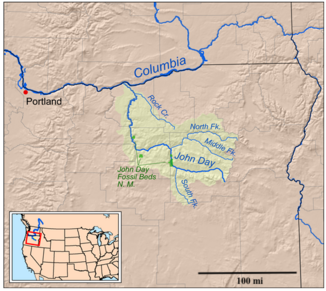
The John Day River drains the west side of the Blue Mountains through its tributaries . It flows in a zigzag course in a north-westerly direction through a sparsely populated part of Oregon east of the Cascade Mountains . It finally flows into the Columbia River above the Columbia River Gorge and above the John Day Dam . Its upper course leads through extremely charming gorges with several important paleontological sites along its banks.
The John Day River has four headwaters:
- The main arm of the John Day River has its source in the Strawberry Mountains in eastern Grant County .
- The North Fork John Day River flows along the western slopes of the Elkhorn Mountains in northeast Grant County.
- The Middle Fork John Day River has its origin near the Blue Mountain summit on the eastern edge of Grant County.
- The South Fork John Day River has its source in northern Harney County , about 10 miles south of the Grant County border.
The main, south, and central arms of the John Day River system come from different parts of the Malheur National Forest , while the north arm drains from the Wallowa-Whitman National Forest . The main arm flows first north, then west through the John Day Valley and through the towns of Prairie City , John Day, and Mount Vernon . At Dayville , in west Grant County, the South Fork flows into the John Day River. The river then flows north through Picture Gorge and the Sheep Rock Unit of the John Day Fossil Beds National Monument . At Kimberley in northwest Grant County, the North Fork meets the John Day River when coming from the east. The North Fork flows further east to the Middle Fork .
The John Day River continues its course in a westerly direction. It flows through Wheeler County and turns north on the county line with Jefferson County . He passes the Clarno Unit of the John Day Fossil Beds National Monument. Its lower course is characterized by meanders. It forms the border between Sherman County in the west and Gilliam County in the east. The Columbia River reaches the John Day River coming from the southeast, about 25 km northeast of Biggs Junction . The river mouth lies on the narrow Lake Umatilla reservoir, which is formed by the damming of the Columbia River by the John Day Dam, about 3 km downstream.
Recreational use and ecosystem
The John Day River can be ridden by rafts and other small craft. Water is taken from its lower reaches to irrigate grain fields and cattle ranches.
In 1988, a 236 km stretch of river from Service Creek to Tumwater Falls was included as the John Day Wild and Scenic River in the National Wild and Scenic River program.
This stretch of the river is a popular spot for fishing for migratory steelhead trout and various perch. White water rafting is another leisure activity on this route.
North Fork John Day River and South Fork John Day River are also designated National Wild and Scenic Rivers .
Web links
- National Park Service: John Day Wild and Scenic River
- Irrigation and the John Day River
- The Nature Conservancy: Middle Fork John Day River
Individual evidence
- ^ John Day River - Bureau of Land Management
- ↑ John Day River in the United States Geological Survey's Geographic Names Information System
- ^ [1] , John Day - Encyclopedia.com
- ↑ John Day Subbasin Plan ( Memento of the original from June 16, 2011 in the Internet Archive ) Info: The archive link was inserted automatically and has not yet been checked. Please check the original and archive link according to the instructions and then remove this notice. , p. 18; Northwest Power and Conservation Council
- ↑ John Day River Basin (PDF; 1.6 MB), Water Resources Data for Oregon, Water Year 2005; USGS
- ^ Middle Fork John Day River in the Geographic Names Information System of the United States Geological Survey
- ↑ North Fork John Day River in the Geographic Names Information System of the United States Geological Survey
- ^ South Fork John Day River in the Geographic Names Information System of the United States Geological Survey
- ↑ National Wild & Scenic Rivers - John Day River ( Memento of the original from October 15, 2011 in the Internet Archive ) Info: The archive link was inserted automatically and has not yet been checked. Please check the original and archive link according to the instructions and then remove this notice.
- ↑ National Wild & Scenic Rivers - North Fork of the John Day River ( Memento of the original from March 12, 2012 in the Internet Archive ) Info: The archive link was inserted automatically and has not yet been checked. Please check the original and archive link according to the instructions and then remove this notice.
- ↑ National Wild & Scenic Rivers - South Fork of the John Day River ( Memento of the original from June 10, 2010 in the Internet Archive ) Info: The archive link was inserted automatically and has not yet been checked. Please check the original and archive link according to the instructions and then remove this notice.


