Northwest Angle
| Angle Township | ||
|---|---|---|
 |
||
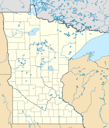
| Location in Minnesota | ||
|
|
||
| Basic data | ||
| State : | United States | |
| State : | Minnesota | |
| County : | Lake of the Woods County | |
| Coordinates : | 49 ° 16 ′ N , 95 ° 3 ′ W | |
| Time zone : | Central ( UTC − 6 / −5 ) | |
| Residents : | 119 (as of 2010) | |
| Population density : | 0.4 inhabitants per km 2 | |
| Area : | 1,544.5 km 2 (approx. 596 mi 2 ) of which 318.8 km 2 (approx. 123 mi 2 ) are land |
|
| Height : | 324 m | |
| Postal code : | 56711 | |
| Area code : | +1 218 | |
| FIPS : | 27-01550 | |
| GNIS ID : | 2397765 | |
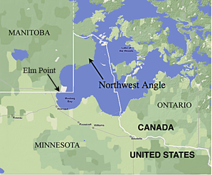
 The Northwest Angle (purple) in Minnesota , adjacent to Manitoba , Ontario and the Lake of the Woods |
||
The Northwest Angle (" Northwest Angle "), officially Angle Township , also known as The Angle for short by locals , is the northernmost part of Lake of the Woods County in the US state of Minnesota . Apart from Alaska , this is the only area of the United States that is north of the 49th parallel .
This latitude forms the border between Canada and the United States west of the Northwest Angles , between Washington , Idaho , Montana , North Dakota and part of Minnesota on the one hand, and British Columbia , Alberta , Saskatchewan and Manitoba on the other. Farther east, US territory does not extend that far north. The northwest corner of the Northwest Angle is 49 ° 23 '4.1 "north latitude, 95 ° 09' 12.2" west longitude.
Like the state of Alaska, Point Roberts in Washington , Elm Point in Minnesota, and Alburgh in Vermont , the Northwest Angle cannot be reached from the rest of the United States without traveling either through Canadian territory or across a body of water; in this case it is the Lake of the Woods .
Much of the area belongs to the Red Lake Indian Reservation ( Ojibwa ), but is not permanently inhabited.
origin
The Peace of Paris (1783) , which was concluded between the United States and the Kingdom of Great Britain at the end of the American War of Independence , stipulated that the Mississippi should be the western border of the newly independent states in its entire length. The northern boundary between the United States and the British possessions in North America was also defined by waters. At its western end, it should run "through the Lake of the Woods to its furthest northwest point and then from there on an exactly westerly course to the Mississippi River". However, the contracting parties were not aware that the source of the Mississippi, Lake Itasca , then unknown to Europeans , was south of it. One reason for this misconception was the use of the Mitchell card during contract negotiations. This map shows a presumed course of the Mississippi up to the upper edge of the map at the 47th parallel and contains the note: “The source of the Mississippi is still unknown. It is believed that it extends up to the 50th parallel and to the western edge of this map. ”The Northwest Angle is thus a result of the ignorance of the geographical conditions in the 18th century. The Treaty of London (1818) corrected the mistake by running the border directly south from the northwest corner of the lake until it reached latitude 49, which it then followed west (since US territory cuts through Louisiana Purchase had expanded westward in 1803). When Johann Ludwig Tiarks carried out measurements in 1825 with the aim of precisely defining the “northwest corner” of the irregularly shaped lake, it was found that the line leading south from there cuts through a bay of the lake and therefore separates the US now known as Northwest Angle -american territory. The also controversial border between the Upper Lake and the Lake of the Woods could not be clarified until 1842, the course of the border within the Lakes of the Woods even not until 1925.
geography
According to the United States Census Bureau , the parish covers an area of 1,544.5 km², of which 318.8 km² is land and 1,225.7 km² (79.36%) is water. It includes several islands and two headlands that extend from the north beyond the 49th parallel to the south and therefore belong to the United States without being connected to it by land. These two areas are in the extreme southwest of the parish, south of the southeast corner of the Canadian province of Manitoba , not far from the northeast corner of Roseau County . In the United States Census 2000 , the population of the Angle was 152 people; 118 of them lived on the mainland and 34 on islands in the Lake of the Woods. All inhabited islands are north of the 49th parallel. The land area consists of the main area with an area of 302.075 km², islands with a total area of 16.325 km² and the two headlands with a total of 0.408 km². The community has the last single classroom school in Minnesota. The border crossing is unoccupied. The travelers who drive the single-lane gravel road in the Angle must submit their customs declaration to the Canadian or US customs authorities via the telephone installed there.
Elm Point
Elm Point , Minnesota, in Lake of the Woods County is a small headland southwest of the Northwest Angle, which extends beyond the 49th parallel to the south and therefore belongs to the United States without being connected to its state territory by land.
Politics and Popular Culture
Separation from the United States and annexation by Canada has been suggested by some residents on occasion, but little has been done because of the non-urgent nature of the matter, lack of public support, and US sovereign rights. In January 2019, a petition was initiated which, if the quorum of 100,000 signatories was reached, is addressed to the American Congress and aims to assign the area to Canada.
Author Tim O'Brien made the area famous for his bestselling novel In the Lake of the Woods .
Demographic data
According to the 2010 census , there were 119 people in 66 households in Angle Township. The population density was 0.4 inhabitants per square kilometer. Statistically, 1.8 people lived in each of the 66 households.
The racial population consisted with the exception of one Native American only from whites .
10.1 percent of the population were under 18 years old, 62.2 percent were between 18 and 64 and 27.7 percent were 65 years or older. 47.1 percent of the population was female.
The average annual income for a household was 14,732 USD . The per capita income was $ 19,924. 75.9 percent of the population lived below the poverty line.
Web links
- Angle Inlet School: Minnesota's last one-room school. In: Lake of the Woods, Northwest Angle - Flag Island webcam. July 31, 2013(English).
- Roger E. Grimsley: Marking the Northwest Angle. In: Professional Surveyor Magazine. September 2004, archived from the original on January 31, 2013 .
- Boundary Commission Coordinates. International Boundary Commission - Canada and United States, archived from the original on May 12, 2006 .
Individual evidence
- ↑ Amy Radil: The Northwest Angle. In: News from Minnesota Public Radio. August 17, 1998, accessed October 20, 2018 (English, transcript and audio file).
- ↑ "The Head of the Mississippi is not yet known: It is supposed to arise about the 50th degree of Latitude, and Western Bound of this Map."
- ^ Petition: Give Northwest Angle, Minnesota, back to Canada. In: Canada online. January 4, 2019, accessed January 25, 2019 .
- Jump up ↑ Find Angle township, Lake of the Woods County, Minnesota. In: American Fact Finder. United State Census Bureau, accessed October 20, 2018 .

