Guttenberg Castle (Palatinate)
| Guttenberg Castle | ||
|---|---|---|
|
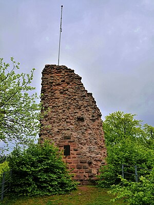
Keep |
||
| Creation time : | around 1150 | |
| Castle type : | Höhenburg, rock castle | |
| Conservation status: | Ruin; Remains of the keep and enclosing walls | |
| Standing position : | Ministeriale, counts | |
| Place: | Oberotterbach | |
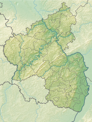
| Geographical location | 49 ° 4 '39.6 " N , 7 ° 55' 16.9" E | |
| Height: | 503.1 m above sea level NHN | |
|
|
||
The Burg Guttenberg (more rarely Guttenburg ) is the ruin of a rock castle near the French border in the German part of the Wasgau that the southern Palatinate Forest ( Rhineland-Palatinate is one).
geography
The castle is located as a hilltop castle in the Upper Mundat Forest about three kilometers west of Oberotterbach at 503.1 m above sea level. NHN high Schloßberg . The Hohe Derst ( 560.5 m ) in the northwest and the Hohe Kopf ( 496.9 m ) in the south join at a distance of one kilometer . The Otterbach , the right source river of the Michelsbach, rises on the northeast slope of the Schloßberg below the castle .
history
The castle was possibly first mentioned in 1151 as a Hohenstaufen imperial castle , which was administered by the Ministerial Landolfo de Gudenburc , or with Ulrich von Guttenberg ( Udelricus de Gudenburhc ), who made a donation to the Eußerthal monastery in 1174 . The first reliable mention is 1246, when Isengard von Falkenstein, on behalf of her husband Reichstruchsess Philipp I von Falkenstein, handed over the castle to King Conrad IV .
From 1317 half of the castle came to the Counts of Leiningen as a fiefdom , while the other half fell to the Electoral Palatinate a little later .
When the Palatinate was divided in 1410, the castle was added to Duke Stefan von Pfalz-Simmern-Zweibrücken . The Leininger lost their share of ownership in 1463, which came via the Hanau-Lichtenberger to the Wittelsbach branch of the Pfalz-Zweibrücken .
In 1525, during the German Peasants' War , Guttenberg Castle was destroyed by the Lorraine farmers. The ruins were not rebuilt and the associated office was moved to Dörrenbach. With the expiry of the Heidelberg line in 1559, Pfalz-Zweibrücken also received the other half of Guttenberg's lordship, including the associated part of the ruinous castle.
1680–1697, the area was under French sovereignty as part of the successes of the reunion policy . From 1792 to 1815 the region was part of France and was assigned to the Bas-Rhin department (Niederrhein department). The area between the Lauter and Queich rivers , including the Guttenberg ruins, came under the sovereignty of Austria due to the agreements made in the Second Peace of Paris (November 1815) . In April 1816, the entire Palatinate was ceded by Austria to the Kingdom of Bavaria in the Treaty of Munich .
After the end of the Second World War , the facility became the property of the State of Rhineland-Palatinate, but was under French administration from 1949 to 1986.
From 1989 to 1995, substance backups were carried out with the support of the board of trustees for the conservation of the Mundat forest .
Castle complex
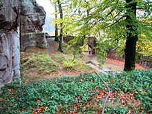
Only small parts of the castle have survived as it was used as a quarry after it was destroyed. Erected on the hilltop, which is crowned by a rocky reef, it originally covered an area of around 50 by 25 meters. Of the three towers of the upper castle on the cliff, only the keep has been partially preserved. In addition, there are still numerous beam and post holes and the remains of a staircase carved into the rock that once served as a connection to the lower castle. Parts of the surrounding wall , building foundations and a gate still exist .
Today the rock of the Oberburg represents a platform that allows a view over the Upper Mundat Forest and the Rhine plain .
Guttenberg reign
The localities belonging to the Guttenberg lordship were divided into the upper and lower communities . The upper one enclosed the village Guttenberg, which later fell into desolation , as well as the villages Oberotterbach , Dörrenbach , Rechtenbach , Mundorf, Har Werden and the exclave Münchweiler . The lower community included Minfeld , Kandel with courtyards and Minderslachen, Freckenfeld , Vollmersweiler and Niederotterbach . After an area swap between Pfalz-Zweibrücken and the Electoral Palatinate in 1786, the previous Guttenberg office became the Zweibrückischen Oberamt, to which the exchanged offices of Selz and Hagenbach were subordinate.
literature
- Magnus Backes, Heinz Straeter: State castles, palaces and antiquities in Rhineland-Palatinate . Schnell und Steiner publishing house, Regensburg 2003, ISBN 3-7954-1566-7 .
- Rolf Übel : Guttenberg . In: Jürgen Keddigkeit , Alexander Thon, Rolf Übel (eds.): Palatinate Burgenlexikon. Vol. 2. F – H (= contributions to the history of the Palatinate ). tape 12.2 . Kaiserslautern 2002, ISBN 3-927754-48-X , p. 251-260 ( excerpt ).
- Alexander Thon (Ed.): ... like a banned, inaccessible magic castle. Castles in the southern Palatinate . 2nd Edition. Verlag Schnell and Steiner, Regensburg 2005, ISBN 3-7954-1570-5 , p. 64-67 .
- Rolf Übel: The Guttenburg near Oberotterbach. The fortified church in Dörrenbach . Verlag für Burgenkunde und Pfalzforschung, Landau 2001, ISBN 3-929893-11-8 .
Web links
- Entry on Guttenberg Castle in the scientific database " EBIDAT " of the European Castle Institute
- Knight castles: Guttenberg castle
- Castle paradise: Guttenberg Castle (photos)
Individual evidence
- ↑ a b c Map service of the landscape information system of the Rhineland-Palatinate nature conservation administration (LANIS map) ( notes )
- ^ Rolf Übel: Guttenberg in Palatinate Burgen Lexicon II F – H , p. 253, Kaiserslautern, 2002, ISBN 3-927754-48-X .
- ↑ Michael Frey: General overview of the history of the royal. bayer. Rhine circle . Neidhard, 1836, p. 442-443 ( Google Books ).


