Oberbeisheim
|
Oberbeisheim
Municipality Knüllwald
Coordinates: 51 ° 2 ′ 5 " N , 9 ° 29 ′ 54" E
|
|
|---|---|
| Height : | 294 (305-507) m above sea level NHN |
| Area : | 8.57 km² |
| Residents : | 561 (Jun 30, 2010) |
| Population density : | 65 inhabitants / km² |
| Incorporation : | December 31, 1971 |
| Postal code : | 34593 |
| Area code : | 05685 |
|
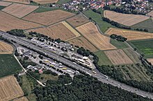
Oberbeisheim from above
|
|
Oberbeisheim is a part of the municipality Knüllwald in the Schwalm-Eder district in Hesse .
geography
State roads 3428 and 3225 meet in the town in the Knüllgebirge in northern Hesse . Federal motorway 7 runs to the west . The Hasselberg motorway service station is close to the town. The place used to have a train station on the Treysa - Niederhone railway line, built in 1878 , which today no longer touches Oberbeisheim.
history
The village was first mentioned in writing in a document from the year 800.
On December 31, 1971, Oberbeisheim was merged with eight other communities to form the new community of Knüllwald.
Individual evidence
- ^ "Oberbeisheim, Schwalm-Eder district". Historical local dictionary for Hessen. (As of December 4, 2015). In: Landesgeschichtliches Informationssystem Hessen (LAGIS).
- ↑ The location on the Knüllwald municipality's website , accessed in August 2015
- ^ Federal Statistical Office (ed.): Historical municipality directory for the Federal Republic of Germany. Name, border and key number changes in municipalities, counties and administrative districts from May 27, 1970 to December 31, 1982 . W. Kohlhammer GmbH, Stuttgart / Mainz 1983, ISBN 3-17-003263-1 , p. 391 .
Web links
- The place on the website of the municipality of Knüllwald
- "Oberbeisheim, Schwalm-Eder district". Historical local dictionary for Hessen. In: Landesgeschichtliches Informationssystem Hessen (LAGIS).
- Literature about Oberbeisheim in the Hessian Bibliography
- Search for Oberbeisheim in the archive portal-D of the German Digital Library

