Orleans, Massachusetts
| Orleans | ||
|---|---|---|
|
|
||
| Basic data | ||
| Foundation : | 1693 | |
| State : | United States | |
| State : | Massachusetts | |
| County : | Barnstable County | |
| Coordinates : | 41 ° 47 ′ N , 69 ° 59 ′ W | |
| Time zone : | Eastern ( UTC − 5 / −4 ) | |
| Residents : | 6,341 (as of: 2000) | |
| Population density : | 172.8 inhabitants per km 2 | |
| Area : | 54.6 km 2 (approx. 21 mi 2 ) of which 36.7 km 2 (approx. 14 mi 2 ) is land |
|
| Height : | 18 m | |
| Postal code : | 02653 | |
| FIPS : | 25-51440 | |
| GNIS ID : | 0618257 | |
| Website : | www.town.orleans.ma.us | |
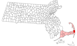
Orleans is a place in Barnstable County , Massachusetts in the United States . The population was 6,341 according to the 2000 census.
history
Orleans was created in 1693 by a settlement of the Pilgrim Fathers from the Plymouth Colony , who were dissatisfied with the poor soil and the little land given them. Originally, the southern parish of Eastham, Orleans was officially independent in 1797. Orleans was named in honor of Louis Philippe II Joseph de Bourbon, duc d'Orléans in recognition of the French support for the 13 colonies during the American Revolution . In addition, the place did not want to have an English name, as it was conquered by the British twice during the war.
In early history, like everywhere else in the Cape, everything revolved around fishing, whaling and agriculture. As the fishing industry grew, salt works were built in the place to preserve the fish. The local growth contributed to the depletion of the forest, which could not be remedied until there was a railway connection that transported wood from the mainland from the mid to late 19th century. The railroad also helped bring tourism to the place. The local tourism industry was helped with the establishment of Cape Cod National Seashores by President John F. Kennedy in 1961 .
geography
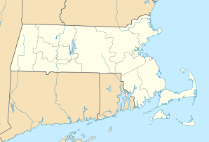
According to the United States Census Bureau , the place has a total area of 54.6 km², of which 36.7 km² is land and 17.9 km² is water. The Nauset is bounded by Eastham to the north, the Atlantic Ocean to the east, Pleasant Bay and Chatham to the south, Harwich to the southwest, Brewster to the west, and Cape Cod Bay to the northwest. Orleans is forty-three kilometers south of Provincetown , thirty-five kilometers east of Barnstable , fifty-eight kilometers east of the Sagamore Bridge, and one hundred and forty-four kilometers southeast of Boston .
Orleans is in the inner "elbow" part of Cape Cod. The place is with swamps and ponds in the western part and with many bays, islands and harbors on the east coast (eg Town Cove, Nauset Harbor, Pleasant Bay and Little Pleasant Bay) littered. Rock Harbor, bounded by and divided by Eastham, lies in the "bend" of the inner elbow and provides boat access to Cape Cod Bay. Cape Cod National Seashore is along the coast.
traffic
The city boundary between Eastham and Orleans is the end of Massachusetts State Route 6A and Massachusetts State Route 28 . The two roads begin together south of the town boundary and end in a roundabout with Massachusetts Route 6 on the town boundary of Eastham. Massachusetts State Route 39 , which runs along part of the Brewster town limits, ends in the southern portion of the city on Massachusetts Route 28.
Orleans has no railway connection and no airport in town. The nearest regional airport can be reached in nearby Chatham and the nearest domestic and international airport is Logan International Airport in Boston.
administration
Orleans is represented in the Massachusetts House of Representatives as part of the 4th Barnstable District, which (except Brewster) includes all places east and north of Harwich on the Cape . The place is represented in the Senate of Massachusetts as part of the Cape and Islands District, which includes Cape Cod, Martha's Vineyard and Nantucket except Bourne, Falmouth, Sandwich and part of Barnstable . The place is controlled by the Second (Yarmouth) Barracks of Troop D of the Massachusetts State Police .
At the national level, Orleans is part of the 10th Congressional District of Massachusetts and is currently represented by Bill Delahunt .
Orleans is administered by the people's assembly administrative form and is led by a local secretary and a board of selectmen . The town has its own police and fire department, both of which are headquartered south of the junction of Massachusetts Highway 6A and Massachusetts Highway 28. There are three post offices, in East Orleans, Orleans Center, and South Orleans. The Snow Library, named after the library's original benefactor, is located in Orleans Center and is supported by the Cape Libraries Automated Material Sharing (CLAMS) network. The place also maintains several beaches, boat landing sites and small parks and has a historical commission that meets in the original town hall of the place (across the street from the current town hall). Orleans also has a building that houses the courthouse for the entire Lower Cape.
education
Orleans is located in the Nauset Regional School District along with Brewster, Eastham and Wellfleet. Each location maintains schools for their own elementary school students and collectively sends their middle and high school students to regional schools. Orleans operates the Orleans Elementary School for students from kindergarten through 5th grade. The place is home to the Nauset Regional Middle School, which serves the educational supply of the students from the 6th to the 8th grade for the district. High school students attend Nauset Regional High School in North Eastham, but also have the free option to attend Cape Code Regional Technical School in Harwich. Orleans is also home to the Cape Cod Lighthouse Charter School, which provides instruction for grades six through eight.
Attacks in time of war
Orleans on Cape Cod and thus in an exposed position on the coast was a target in wartime despite its lack of strategic importance. In 1814, the residents repulsed the invasion of the British Navy from HMS Newcastle . Nauset Beach was the only US location that was contaminated with foreign ammunition during World War I. This was the first time since the British-American War that a foreign power fired on American soil. (See Attack on Orleans .)


