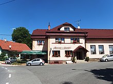
Palačov
| Palačov | ||||
|---|---|---|---|---|
|
||||
| Basic data | ||||
| State : |
|
|||
| Region : | Moravskoslezský kraj | |||
| District : | Nový Jičín | |||
| Municipality : | Starý Jičín | |||
| Area : | 414 ha | |||
| Geographic location : | 49 ° 33 ' N , 17 ° 55' E | |||
| Height: | 300 m nm | |||
| Residents : | 223 (2011) | |||
| Postal code : | 742 31 | |||
| License plate : | T | |||
| traffic | ||||
| Street: | Starý Jičín - Hustopeče nad Bečvou | |||
Palačov (German Palzendorf ) is a district of the Starý Jičín municipality in the Czech Republic . It is located eight kilometers southwest of Nový Jičín and belongs to the Okres Nový Jičín .
geography
Palačov is located in the valley of the brook Mřenka in Podbeskydská pahorkatina ( Vorbeskidenhügelland ). The Jasenka flows into the Mřenka below the village. The state road I / 48 runs between Bělotín and Nový Jičín one kilometer north . In the north rises the Pahrbek (340 m nm), northeast of the Horečky (406 m nm), in the east of the Dlouhý kopec (585 m nm) and the Petřkovická hora (608 m nm), southeast of the Rokytí (358 m nm)
Neighboring towns are Starojická Lhota in the north, Vlčnov , Stary Jicin , Jičina and Janovice in the Northeast, Petřkovice the east, Perná and Vysoká in the southeast, Lešná in the South, Poruba , Hustopeče nad Bečvou and Milotice nad Bečvou in the southwest, Vysoká in the west and dub in Northwest.
history
The first documentary mention of the village Palaczow took place in 1377 under the property of the Titschein Castle . At that time the owners were the Lords of Krawarn . Later followed u. a. the lords of Boskowitz , from 1500 the lords of Zierotin , after the battle of the White Mountain the barons Hofmann von Grünbüchel, from 1706 the barons Zeno zum Danhaus and from 1772 the imperial counts von Seilern and Aspang .
In 1835 Palzendorf or Palačow consisted of 52 houses in which 331 people lived. There was a private school in the village. To Palzendorf was konskribiert the single Meierhof Kersh ( Palačovská Keř ). The parish was Alt Titschein . Until the middle of the 19th century, Palzendorf remained subject to the Alt Titschein rule.
After the abolition of patrimonial Palačov formed from 1849 a municipality in the judicial district of Neutitschein . In 1853 a one-class village school opened. From 1869 Palačov belonged to the Neutitschein district. At that time the village had 343 inhabitants and consisted of 56 houses. In 1900 there were 354 people in Palačov, compared to 351 in 1910. In 1905, Friedrich Deym von Střítež acquired the Starý Jičín manor. In 1930 Palačov consisted of 59 houses and had 335 inhabitants. After the Munich Agreement , the purely Moravian-speaking village was initially added to the German Reich in 1938. In the course of further border regulations, Palačov was spun off again from the Neu Titschein district on November 24, 1938 and returned to Czechoslovakia together with the settlement Palačovská Keř, which was separated from Starý Jičín . Until 1945 Palačov was then assigned to the newly formed Wallachisch Meseritsch district and came back to Okres Nový Jičín after the end of the war. In 1955 the cemetery was laid out. There was a kindergarten in the village until the 1970s. At the beginning of 1979 Palačov was incorporated into Starý Jičín. In the 2001 census, there were 216 people in the 79 houses in Palačov. As of January 1, 2018, the village had 225 inhabitants and consisted of 97 houses.
Local division
The district Palačov forms a cadastral district.
Attractions
- chapel
- Memorial stone for those who fell in World War I, at the bakery
- Liberation memorial stone on the village square unveiled in 1960
- Memorial to the crash of a US B-24 in December 1944. The stone mound with a replica of a propeller is located one kilometer south of the village on the road to Lešná.
- Memorial plaque on the house where František Váhala was born
economy
In Palačov there is a guest house, a joinery, a sawmill, a bakery known for its Wallachian frgál and a microbrewery that produces the Paličák beer brand .
Sons and daughters of the place
- Augustine II. Pavel Vahala (1802–1877), Bishop of Leitmeritz
- František Váhala (1881-1942), lawyer, writer and resistance fighter, he was on 3 July 1942 at the Kaunitz dorm executed
literature
- Historický lexikon obcí České republiky 1869–2005 , part 1, p. 724
Web links
Individual evidence
- ↑ http://www.uir.cz/katastralni-uzemi/717380/Palacov
- ^ Gregor Wolny : The Margraviate of Moravia, presented topographically, statistically and historically . Volume I: Prerauer Kreis, Brno 1835, p. 43
- ↑ http://www.uir.cz/katastralni-uzemi/717380/Palacov
- ↑ https://encyklopedie.brna.cz/home-mmb/?acc=profil_osobnosti&load=5578


