Poneggen
| Poneggen ( village ) | ||
|---|---|---|
|
|
||
| Basic data | ||
| Pole. District , state | Perg (PE), Upper Austria | |
| Judicial district | Perg | |
| Pole. local community | Schwertberg ( KG Schwertberg) | |
| Locality | Schwertberg | |
| Coordinates | 48 ° 16 ′ 0 ″ N , 14 ° 34 ′ 0 ″ E | |
| height | 257 m above sea level A. | |
| Postcodes | 4311 Schwertberg | |
| Primaries | + 43/7262, 7235, 7236, 7237, 7238 | |
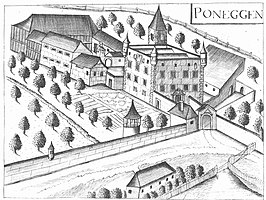
 Engraving from the 17th century |
||
| Source: STAT : index of places ; BEV : GEONAM ; DORIS | ||
|
Poneggen ( single farm ) locality |
|
|---|---|
| Basic data | |
| Pole. District , state | Perg (PE), Upper Austria |
| Judicial district | Perg |
| Pole. local community | Ried in der Riedmark ( KG Ried in der Riedmark) |
| Coordinates | 48 ° 16 ′ 0 ″ N , 14 ° 34 ′ 0 ″ E |
| height | 257 m above sea level A. |
| Residents of the village | 3 (January 1, 2020) |
| Post Code | 4311 Ried in the Riedmark |
| Statistical identification | |
| Locality code | 10215 |
| Counting district / district | Ried area (41 118 001) |
| Source: STAT : index of places ; BEV : GEONAM ; DORIS | |
Poneggen is a village in the market town of Schwertberg .
The village of Poneggen (Pöniken, Ponecken) is located at 257 m above sea level. A. west of the center of Schwertberg and also extends to a small extent to the municipality of Ried in der Riedmark . In the administration of the market town of Schwertberg the village Poneggen is listed as a street name, in the administration of the market town of Ried in der Riedmark as a locality.
In the west the village borders the village Niederzirking and Gerersdorf the town of Ried in the Riedmark , on the north by the Schwertberger village of Doppl , on the south by the Schwertberger village Aisting and east to the village of Schwertberg.
The name is derived from the Old Slavic word Ponikava for water hole. Poneggen is mentioned by name in connection with Poneggen Castle and with the stocking manufactory located there at the end of the 18th and beginning of the 19th centuries, Poneggen is today a rapidly growing district of Schwertberg with many young families.
geography
The village is traversed by the Poneggenbach, which rises in the southern part of the village of Doppl, in an approximately north-south direction and then turns to the east and flows into the Aist in the area of the Steinbach and Hödlmayr companies .
The village is separated into a northern and a southern part by the state road L 1412 (Schwertberger Strasse). The tracks of the Donauuferbahn run from southwest to northeast across the southern part of the village area. Part of the village area is in the Machland , the rest on the southern Mühlviertel outskirts
- Poneggen volunteer fire department
There has been a volunteer fire brigade in Poneggen since 1905 , which was founded as a branch of the Schwertberg fire brigade. The innkeeper Franz Eder provided a piece of land for the construction of a depot. The construction was generously supported by the community of Schwertberg and the manor of Schwertberg . On June 2, 1946, the Poneggen branch became an independent fire brigade, which joined the district and state fire brigade association . In 1949 and 1950, a new fire department depot was built, for which the Wahl and Kroiss families provided the land free of charge. A fire brigade soccer team founded in 1962 made the fire brigade popular with the youth, and in 1973 a separate fire brigade youth group was founded. In 2004 the new fire station in the Achhornersiedlung was inaugurated.
- Waste material collection center
Together with the neighboring communities of Mauthausen and Ried in der Riedmark, the market community of Schwertberg set up a cross-community waste material collection center in Poneggen about 100 meters south of the Poneggenbach .
- Companies
- Glas Lumetsberger OG
- Praher Group (Praher Plastics Austria)
- ML electronics, Markus Lindbichler
history
The village was created in the immediate vicinity of Poneggen Castle. In the 19th century there were 55 houses with 77 tenants and 297 residents.
The name Poneggen, recorded as "Pöniken" in 1297, "Ponik" in 1307, "Poniken" in 1378, "Puniken" in 1380, comes from the Old Slavic word ponikva - water hole, a place where the water disappears underground.
Culture and sights
- Poneggen Castle is privately owned, today it houses rental apartments and the building is a listed building
- Häuselzeile Poneggen, one of the oldest row house settlements still occupied by workers in Austria
Personalities
- Cäcilia Weber (* 1877 in Poneggen), married Cilli Löwinger, actress and manager of the Löwinger-Bühne , mother of Paul Löwinger
swell
- 41124 - Schwertberg. Community data, Statistics Austria .
- Georg Grüll : The Poneggen stocking factory from 1763 to 1818. A picture from the age of Austrian universal commerce. With 8 panels. In: Communications from the Upper Austrian Provincial Archives. 6th volume, Linz 1959, pp. 5–135, online (PDF) in the forum OoeGeschichte.at, pictures (PDF) in the forum OoeGeschichte.at.
- Othmar Wandl (author), SPÖ Schwertberg (editor): The Poneggen stocking factory 1763 to 1818. In: Attitude - Movement - Party in the light of the red carnation. Festschrift Soc. democratic Local organization Schwertberg. Founded in 1890, Schwertberg, 1990, p. 16ff.
Individual evidence
- ↑ Poneggen stocking factory , in: Regiowiki.at website accessed on November 24, 2017.
- ^ Benedikt Pillwein : History, geography and statistics of the Archduchy above the Enns. Volume 1, Vienna 1827, p. 407.
