
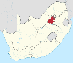
Gauteng
| Gauteng | ||
|---|---|---|
  |
||
| Symbols | ||
|
||
| Basic data | ||
| Country | South Africa | |
| Capital | Johannesburg | |
| surface | 18,178 km² | |
| Residents | 12,272,263 (2011) | |
| density | 675 inhabitants per km² | |
| ISO 3166-2 | ZA-GP | |
| Website | www.gauteng.gov.za (English) | |
| politics | ||
| prime minister | David Malemolla Makhura | |
| Political party | ANC | |

Coordinates: 26 ° 12 ′ S , 28 ° 0 ′ E
Gauteng is one of the nine provinces in South Africa . Its capital is Johannesburg . Gauteng was formed from part of the Transvaal Province after the first elections with the inclusion of the black majority on April 27, 1994 . The new province was originally named Pretoria-Witwatersrand-Vereeniging (PWV). In December 1994 the name was informally changed to Gauteng . However, the new name only became official and therefore binding with the Constitution of the Republic of South Africa Amendment Act No. 20 of 1995 from July 1995 into force.
With an index value of 0.703 in 2015, Gauteng has the second highest human development index among all provinces in the country.
Surname
The word Gauteng comes from the Sesotho and means "place of gold", whereby the word part gauta itself is derived from the Dutch word goud , gold. The name refers to the former importance of the area in gold mining .
geography
Gauteng has an area of 18,178 km². This corresponds to about 1.5% of the land area of South Africa. This makes Gauteng the smallest province in South Africa in terms of area. However, the province is densely populated. In 2011 around 12.3 million people lived there, almost a quarter of the entire population of South Africa. Gauteng is the province with the highest population growth. Between 1996 and 2001 alone, the number of residents increased by more than 20%. Due to sustained population growth, Gauteng has replaced the province of KwaZulu-Natal as the most populous province.
Despite its small area, Gauteng is the economic center of South Africa; 34% of the South African and 10% of the gross domestic product of the whole of Africa are generated here.
Districts with the parishes
The territorial structure of the Gauteng Province consists of 2 districts with 6 local parishes and three metropolitan parishes (as of July 2020):
.svg)
| District / Metropolitan Municipality | Local parishes | |
|---|---|---|
| 1. | Sedibeng | Emfuleni , Lesedi and Midvaal |
| 2. | West edge | Merafong City , Mogale City and Rand West City |
| 3. | City of Johannesburg Metropolitan Municipality | Metropolitan municipality |
| 4th | City of Tshwane Metropolitan Municipality | Metropolitan municipality |
| 5. | City of Ekurhuleni Metropolitan Municipality | Metropolitan municipality |
Population and languages

According to the results of the 2011 census, 74.1% of the population were black, 19.1% were white, 3.5% were colored and 2.6% were Indians and Asians.
17.8% of the population reported isiZulu as their mother tongue, English 14.3%, Afrikaans 13.8%, Sesotho 11.6%, North Sotho 10.6%.
Population development
Gauteng's population development is the most dynamic in all of South Africa. The following overview shows the population by area since the 1996 census.
| year | population |
|---|---|
| 1996 (census) | 7,834,125 |
| 2001 (census) | 9,388,854 |
| 2011 (census) | 12,272,263 |
| 2018 (estimate) | 14,717,000 |
politics

In the 2019 elections to the Provincial Legislature , the ANC in Gauteng remained the strongest party despite losses. The mandates are distributed as follows.
| Political party | Seats | +/- |
|---|---|---|
| African National Congress (ANC) | 37 | −3 |
| Democratic Alliance (DA) | 20th | −3 |
| Economic Freedom Fighters (EFF) | 11 | +3 |
| Vryheidsfront Plus (VF +) | 3 | +2 |
| Inkatha Freedom Party (IFP) | 1 | ± 0 |
| African Christian Democratic Party (ACDP) | 1 | +1 |
| total | 73 |
Sights (selection)
- In Gauteng, the almost 50,000 hectares, is Cradle of Humankind , cradle of humanity ' called World Heritage of UNESCO .
- Tswaing meteorite crater
- Wonder Cave
Nature reserves
|
|
Web links
- Gauteng Provincial Government: website of the provincial government (English)
- Gauteng Provincial Government: Gauteng Provincial Government Departments . on www.gauteng.gov.za (English), overview of the ministries and regional head offices
- Gauteng Provincial Government: Municipalities . on www.gauteng.gov.za (English)
- Statistics South Africa : Statistics by place . at www.statssa.gov.za (English), interactive representation of the provinces
Individual evidence
- ↑ Statistics South Africa : Census 2011, Census in brief . online at www.statssa.gov.za (English, PDF file; 2.8 MB), PDF document p. 23, doc. p. 18.
- ^ SAIRR : South Africa Survey 1995/96 . Johannesburg 1996, p. 440.
- ↑ Republic of South Africa: No. 20 of 1995: Constitution of the Republic of South Africa Amendment Act, 1995 online at www.justice.gov.za (PDF), In: Government Gazette , July 3, 1995, Vol. 361, No. 16522, pp. 5.
- ^ Sub-national HDI - Area Database - Global Data Lab. Accessed August 5, 2018 . .
- ↑ Statistics South Africa : Stats in brief, 2009 . online at www.statssa.gov.za (English, PDF file; 4.1 MB), accessed on July 13, 2020.
- ^ Local Government Handbook. South Africa: Gauteng Municipalities . at www.municipalities.co.za (English).
- ↑ Statistics South Africa (Ed.): Census 2011: Census in brief . Pretoria 2012, ISBN 978-0-621-41388-5 ( gov.za [PDF]).
- ↑ City Population: South Africa: Provinces and Major Settlements - Population Statistics, Maps, Charts, Weather, and Web Information. Retrieved January 7, 2019 . (English).