
Pryasha
Urban-type settlement
|
||||||||||||||||||||||||||||||
|
||||||||||||||||||||||||||||||
|
||||||||||||||||||||||||||||||
.svg)

Prjascha ( Russian Пря́жа ; Karelian Priäžä ) is an urban-type settlement in the Republic of Karelia in Russia with 3675 inhabitants (as of October 14, 2010).
geography
The place is about 40 km as the crow flies west-southwest of the republic capital Petrozavodsk and Lake Onega . It is located on Lake Priashinskoye, a few kilometers from the right bank of the Shuja River.
Prjascha is the administrative center of Prjaschinski Rajons and the seat of the municipality Prjaschinskoje gorodskoje posselenije, which also includes the village Kindasovo (10 km west-northwest on the Shuja) and the village and the settlement Manga (about 12 km southwest).

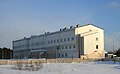
District administration
hospital

Library


history
The place was first mentioned in a document in the 1580s as "Village on Lake Prjascha". From the 18th century the village developed economically through forestry, charcoal burning and the extraction of turf iron stone for the "Olonec ironworks" that were built in southern Karelia, such as the Shuja plant in today's Petrozavodsk.
During the Finnish campaigns to the east after gaining independence in 1918, Finnish troops managed to briefly capture Prjascha from April 29 to the end of June 1919 while advancing on Petrozavodsk as part of their Olonets campaign.
On February 28, 1930 Prjascha became the administrative seat of a newly created Rajons named after him.
In the Finnish-Soviet Continuation War , Prjascha was occupied by Finland from September 1941 to the end of June 1944 and was called Teru during this time . Both 1941 and 1944, the place was highly competitive.
In 1962 the place received the status of an urban-type settlement.
Population development
| year | Residents |
|---|---|
| 1939 | 1898 |
| 1959 | 2519 |
| 1970 | 4112 |
| 1979 | 4809 |
| 1989 | 4421 |
| 2002 | 4269 |
| 2010 | 3675 |
Note: census data
traffic
The federal trunk road R21 Kola Saint Petersburg - Murmansk runs through Prjascha . On the southern outskirts, the federal highway A121 Sortavala branches off via Sortavala to Saint Petersburg, part of the shortest connection between the republic capital Petrozavodsk and the Finnish border.
Petrozavodsk is also the closest train station to the Murman Railway Saint Petersburg - Murmansk.
Web links
Individual evidence
- ↑ a b Itogi Vserossijskoj perepisi naselenija 2010 goda. Tom 1. Čislennostʹ i razmeščenie naselenija (Results of the All-Russian Census 2010. Volume 1. Number and distribution of the population). Tables 5 , pp. 12-209; 11 , pp. 312–979 (download from the website of the Federal Service for State Statistics of the Russian Federation)
| Cities |
Belomorsk R | Kem R | Kondopoga R | Kostomuksha S | Lachdenpochja R | Medvezhyegorsk R | Olonez R | Petrozavodsk S / R | Pitkjaranta R | Pudosch R | Segescha R | Sortawala R | Suojarwi R |
|
| Urban-type settlements |
Cheljulja | Kalewala R | Louchi R | Mujeserski R | Nadwoizy | Pinduschi | Pjaoserski | Powenez | Pryasha R | Chupa | Vjartsilja |