
Powenez
city
|
||||||||||||||||||||||||||||||||||||||
|
||||||||||||||||||||||||||||||||||||||
|
||||||||||||||||||||||||||||||||||||||
| List of cities in Russia | ||||||||||||||||||||||||||||||||||||||
_(1788).png)
.svg)

Powenez ( Russian Повенец ; Karelian Povenča ; Finnish Poventsa ) is an urban-type settlement in Medweschjegorski Raion in the Republic of Karelia in Russia .
location
Powenez is located at the mouth of the eponymous river Powentschanka in the Bay of Powenez ( Повенецкая Губа ) at the northern end of Lake Onega . In a topography from 1841, the surrounding area is described as "large, very watery and very stony here and there". The mineral kingdom supplies “iron and copper ore, gold; Pearls in the Powjetschanka ”it continues. In terms of traffic, today's municipality is connected to the national road network with the A119 Vologda - Medweschjegorsk highway . Neighboring towns are in the northwest Medvezhyegorsk, which is about 25 kilometers away and the nearly 150 kilometers southeast lying Pudozh .
Powenez is the seat of the municipality Powenezkoje gorodskoje posselenije, which also includes the 4 villages Gabselga, Lobskoje, Sosnowka and Tichwin Bor as well as the 13 settlements (possjolok) Chischosero, Morskaja Masselga, Lobskoje, Novaya Gabselga, Possjolok pri 9 Schljselga BBK (except Possjolok pri 6 schljuse BBK; translated as "settlement at the 1st" to "9th lock of the Baltic-White Sea Canal", except for "6th") and Verkhneje Wolosero belong.
history
The area was first settled in the Mesolithic Age , as evidenced by many petroglyphs found in the area. In addition, archaeological excavations that have been carried out at Powenez for many years indicate one of the oldest human settlements on the shores of Lake Onega.
The establishment of Powenez is believed to be related to efforts to find a northern route, the so-called Northeast Passage , to China . First inquiries into the area are documented around the middle of the century. In July 1566, Thomas Southam and John Sparke started an expedition inland from Cholmogory from the White Sea . Their exploration on behalf of the Anglo-Russian trading company Muscovy Company was intended to find a navigable trade route into the territory of the Novgorod Republic . Their route led them on a lodje , a compact type of barge , first to the Solovetsky monastery . There they took a guide for the first and most difficult part of the way and sailed into the mouth of the Vyg near today's Belomorsk .
They drove as far as they could up the river in three small boats. Often they had to drag the boats overland until they finally reached Lake Wyg , which was admittedly not dammed at the time. We went on the river Telekinka ( Телекинка ) and Lake Telekino ( Телекино ) - both are gone when damming of WYG Lake - to this Povenets that owned at that time of Wjaschischtschski Monastery ( Вяжищский монастырь ) in Novgorod found.
As a result, many merchants set up warehouses on the shores of Powenez Bay to promote their trade in salt, fish and furs from the White Sea region, and eventually a trading settlement was created that grew steadily. The route to the north was not only interesting for trade, it also allowed many believers to make a pilgrimage to the shrines of the Solovetsky monastery and was therefore called the “pilgrims' path”.

During the Great Northern War in 1702, Tsar Peter the Great felled the trees along the route. The purpose of the deforestation, the consequences of which can still be traced to this day and which entered history as "Petrowskaya prosseka" ( Петровская просека ), that is, "Peter's swath", was to pull two warships of the White Sea Fleet from Onegabusen to Lake Onega on the trunks . The two frigates Kurjer ( Курьер ; "Kurier") and Swjatowo Ducha ( Святого Духа , "Holy Spirit") were each equipped with 12 cannons and were decisive in the siege of Nöteborg , which was victorious for the Russians . Since then, the route has also been known as the Tsar's Street or in Russian «Осударева дорога», transcribed as "Ossudarewa doroga".
At that time, Tsar Peter stayed in Powenez for a long time or repeatedly, because he is credited with founding an iron foundry called Paveletsky ( Павйѣлйѣтзкй , in contemporary spelling) on the banks of the Powentschanka. The factory, which employed up to 500 workers, produced cannons, swords and rigging items for the Russian fleet. The company owned by the Krone ensured that the community flourished for a short time. However, the upswing came to an end as early as 1734 after the tenant's death because nobody could be found who wanted to continue the business. Only the ruins of the blast furnace remain from the former facility.
In 1761 the first Peter and Paul Church was built and in 1777 Powenez was granted town status. In 1780 the place also received city rights and was ruled first from Saint Petersburg and then until 1796 by the provincial administration in Olonez . Since then, the coat of arms has been a reminder of belonging to the historical province of Olonez.
In 1796 the Olonez Governorate was dissolved and Powevez was added to the Arkhangelsk Governorate . In 1799, Povenez was revoked from the status of a district town and downgraded to the Possad ( Повенецкий посад ) in the Kem district . After the restoration of the province of Olonez in 1801, these regulations were soon reversed.
The idea of overcoming the isthmus between Lake Onega and the bay with a canal must have existed as early as the time of Peter the Great. In the 18th century, at the suggestion of merchants from Petersburg, Petrozavodsk and Arkhangelsk, concrete plans for building a canal were considered. The Russian general, military engineer and architect Franz Páwlowitsch de Wollán was called in as an expert. The builder of the Mariinsky water system, the forerunner of today's Volga-Baltic Sea Canal , rejected this first draft because there were "too many rocks, waterfalls and other obstacles".
Another attempt was made in the 19th century under the leadership of the Free Economic Society . In 1867, however, this project was also abandoned due to excessive costs. According to Pierer's Universal Lexicon of 1857, the city had 23,000 inhabitants at that time.
In 1900 Vsevolod Yevgenyevich Timonov was awarded a gold medal at the Paris World's Fair . The professor of water technology and specialist in port and canal construction received the award for an essay on the connection of the White Sea with Lake Onega via a ship canal. This work may have been instrumental in the final design of the Belomor Canal. But the proletarian revolution had to take place first to bring the old dream of Peter the Great to life.
The neighboring Medweschjegorsk was connected to the railway line of the Murmanbahn from Saint Petersburg to Murmansk in 1916 and Powenez increasingly lost its importance and finally once again lost its administrative position as a city.
When the construction of the White Sea-Baltic Sea Canal began in 1931 , the settlement could play a role again as the southern end of the waterway. By exploiting forced laborers in Stalin's inhuman gulag system , the monumental structure could be completed within just one year and eight months and cost the lives of thousands of prisoners .
In 1938 Powenez was given city rights back. However, it was unable to regain its former status as a transhipment point, which was not least due to the canal's low economic importance compared to the railroad and which is still there today. Even the management of the White Sea-Baltic Canal is located in 26 km away Medvezhyegorsk .
Powenez suffered another setback in his development when Finnish troops allied with fascist Germany occupied the region as far as the west bank of the canal during World War II . The soldiers of the Red Army withdrew from Povenets and blew up on December 6, 1941, dam of Lake Vygozero -Stausees and locks up Povenets into the air. The falling water destroyed the “Powenez Staircase” (“Повенецкая лестница”), as the first seven locks of the canal were called. Many houses were damaged in the city itself, but further advance of the Finnish army was halted. On June 21, 1944, the Red Army liberated Powenez, or rather what was left of it. From autumn 1944 to June 16, 1946, imprisoned Soviet soldiers and officers who had been German prisoners of war and Germans deported to Kazakhstan had to rebuild the route at great risk, because the surrounding area was still mined.
Powenez was also rebuilt in a very short time after the war. The square plan, which is based on the historic course of the street, as it was once designed according to the principles of an ideal city , is remarkable . However, all that remains is a small village, five streets wide and five streets long, built on with many one- to two-story wooden houses and a few, mostly five-story prefabricated buildings , the so-called Khrushchevkas .
In the 1960s and 1970s, Powenez served as a place of exile, as it did sometimes in its eventful history.
- Gallery: past and present

City map of Powenez 1784

Old and New Peter and Paul Church around 1910

Destroyed lock,
picture from December 9, 1941
Image of the flooded city
from December 18, 1941
The entrance to the village,
coming from Medvezhyegorsk
One of the many dead straight streets
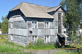
Residential buildings in Powenez in August 2013


.jpg)

.jpg)
Population development
The population development continues to decline sharply. While the 1959 population census registered 4044 residents, the 2010 census recorded 2209 residents.
| year | Residents |
|---|---|
| 1897 | 1294 |
| 1939 | 4875 |
| 1959 | 4044 |
| 1970 | 3941 |
| 1979 | 3766 |
| 1989 | 4208 |
| 2002 | 2608 |
| 2010 | 2209 |
Note: census data
climate
| Powenez 62 ° 50 '56 "N / 34 ° 49' 30" E, 40 m | ||||||||||||||||||||||||||||||||||||||||||||||||
|---|---|---|---|---|---|---|---|---|---|---|---|---|---|---|---|---|---|---|---|---|---|---|---|---|---|---|---|---|---|---|---|---|---|---|---|---|---|---|---|---|---|---|---|---|---|---|---|---|
| Climate diagram | ||||||||||||||||||||||||||||||||||||||||||||||||
| ||||||||||||||||||||||||||||||||||||||||||||||||
|
Average monthly temperatures and rainfall for Powenez
62 ° 50 '56 "N / 34 ° 49' 30" E, 40 m
Source: Climate-Data.org
|
||||||||||||||||||||||||||||||||||||||||||||||||||||||||||||||||||||||||||||||||||||||||||
The climate in Powenez is cold and temperate and, according to the Köppen and Geiger climate classification, corresponds to the type Dfb, which characterizes the Baltic Sea region . In the humid continental climate, which is due to the proximity to the sea and the many rivers and lakes, significant amounts of rainfall can be recorded during the year, even in the driest month of February. The temperature is evenly distributed over the seasons. In the warmest month of July, the thermometer rises to around 20 degrees plus, in January, the coldest month, it falls almost to the same amount below zero.
economy
- Fur farming
- Nearby, foxes and minks are bred at one of the country's largest fur farms to provide arctic fox , blue fox and mink fur .
- First Powenezer Schauermann Society;
- the “Society of Dock Workers” ( “Первая Повенецкая Стивидорная Компания” ) looks after the berths in the Powenez port.
- In addition, agriculture, forestry and fishing form the economic basis of the population.
Attractions

The breakwater in front of the harbor

One of the locks of the White Sea-Baltic Sea Canal

A cargo ship entering the first lock chamber of the canal
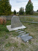
Memorial plaque of the Zarenstrasse

The sculpture of Saint Nicholas

... the church consecrated to him from the outside ...
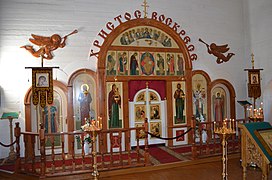
... and from within
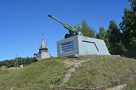
A ZIS-3 howitzer as a memorial to the Great Patriotic War

The Sandarmoch Memorial


- The port and lock system
- The remains of the blast furnaces of the Powenez ironworks
- The Museum of the White Sea-Baltic Sea Canal;
- the few exhibits suggest how small the funds used for construction were.
- The Church of St. Nicholas the Wonderworker;
- The building made of exposed concrete with visible wooden structures of the formwork was only built in 2003 and is modeled on the old Peter and Paul Church that was destroyed in the Second World War.
- Sandarmoch (Russian Сандармох; Karelian: Sandarmoh)
- Today's memorial, the site of the mass shootings during the Great Terror, is 19 kilometers from Powenez.
Web links
Individual evidence
- ↑ Itogi Vserossijskoj perepisi naselenija 2010 goda. Tom 1. Čislennostʹ i razmeščenie naselenija (Results of the All-Russian Census 2010. Volume 1. Number and distribution of the population). Tables 5 , pp. 12-209; 11 , pp. 312–979 (download from the website of the Federal Service for State Statistics of the Russian Federation)
- ↑ Fedor Possart, Kaisertum Rußland: Topographie, Volume 2 (spelling of the river name in the formerly valid transcription )
- ↑ Field studies catalog. Volume 5, 1969–1971 (Russian)
- ↑ Joseph Hamel, Tradescant der Aeltere 1618 in Russia. The development of trade between England and Russia (etc.), Eggers u. Comp u. Voss, 1847
- ↑ KARELIA tourist portal
- ↑ St. Petersburg - The city on the White Sea-Baltic Sea Canal
- ↑ Povenets in Pierer's Universal-Lexikon 1857
- ↑ Solovki
- ↑ 1959 census
- ↑ Karelia USSR
- ↑ Page of the administration of the Belomor Canal
| Cities |
Belomorsk R | Kem R | Kondopoga R | Kostomuksha S | Lachdenpochja R | Medvezhyegorsk R | Olonez R | Petrozavodsk S / R | Pitkjaranta R | Pudosch R | Segescha R | Sortawala R | Suojarwi R |
|
| Urban-type settlements |
Cheljulja | Kalewala R | Louchi R | Mujeserski R | Nadwoizy | Pinduschi | Pjaoserski | Powenez | Pryasha R | Chupa | Vjartsilja |