Pueblo Mountains
| Pueblo Mountains | |
|---|---|
|
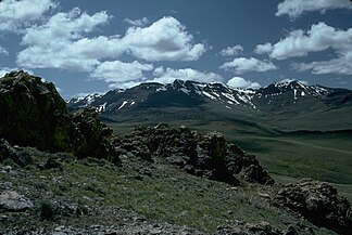
Pueblo Mountains south of Fields, Oregon |
|
| Highest peak | Pueblo Mountain ( 2625 m ) |
| location | Oregon and Nevada , USA |
| part of | Basin and Range Province |
| Coordinates | 42 ° 6 ′ N , 118 ° 39 ′ W |
| Type | raised sediments and volcanic |
| rock | basalt |
| Age of the rock | Triassic and Chalk |
| surface | 920 km² |
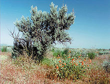
The Pueblo Mountains are a remote mountain range in the United States . It is located in southeast Oregon and northwest Nevada . The highest peak is that of Pueblo Mountain . The predominant vegetation in this mountain range is grass and sagebrush ( Artemisia tridentata ); there are also bushes with black poplars , aspens and willows growing along some watercourses . Most of the Pueblo Mountains are public land administered by the Bureau of Land Management . The area is sparsely built and most visitors come for hiking, camping, and hunting.
geology
The Pueblo Mountains in southeastern Oregon are that part of the Basin and Range Province of the Western United States , which is characterized by a series of parallel clods and long mountain ranges in north-south direction, which are separated by wide high mountain step valleys. The Steens-Pueblo debris block forms the northernmost branch of these structures. The Puebloketto is not as massive as the Steens Mountains ; However, it is inclined at an angle of 45 degrees, so much more than the Steenskette. This contributes to the relatively high main ridge line of the mountain range, which averages 220 m above sea level.
The mountain range is made up of the same basalt that covers much of southeastern Oregon, but the Pueblo Mountains are made up of much older metamorphic rock strata underlying newer basalt strata. These older rock layers form a steep drop on the east side of the mountain range . These rocks are possibly related to the Triassic formations of the Blue Mountains Province further north. These strata have inclusions of diorite and granodiorite , which were probably created in the Cretaceous period . The southern section of the Pueblo chain is made up of metamorphic rock rich in quartz interspersed with gold , silver and copper .
topography
The Pueblo Mountain cover an area of 920 square kilometers. They extend over 48 km in north-south direction and over 35 km in west-east direction. The highest point of the mountain range is the summit of Pueblo Mountain at 2631 m above sea level. This peak is located in Oregon, about eight miles north of the Nevada state line. Directly west of Pueblo Mountain is the highest point of the West Pueblo Ridge; at 2570 m it is the second highest point in the Pueblo Mountains. This ridge forms a westward sloping steep drop that runs the entire length of the Pueblo Mountains.
The landscape of the Pueblo Mountains is characterized by rugged ridges with steep drops that have been cut by seasonal water-bearing courses. In between there are high desert-like basins and, near springs, meadow areas, of which Machine Meadow and 10 Cent Meadow are the two largest. There are only a few rivers in the Pueblo Range that are water-bearing year-round, including Van Horn Creek and Denio Creek .
Flora and fauna

The vegetation in the Pueblo Mountains is dominated by tall sagebrush and steppe grasses. The native grass species include Idaho fescue , Pseudoroegneria spicata , Dach-Trespe , Achnatherum thurberianum , Flat-eared Trepse ( Bromus carinatus ), Poa secunda and Elymus elymoides . There are mountain meadows high at springs as well as narrow green corridors along the year-round water-bearing rivers. In some of them, poplars, aspens and willows thrive. Meadows and high mountain Steppe flowers that thrive in the Pueblo Mountains are, inter alia, delphiniums , Castilleja , Potentilla , primrose , aquilegia , Mimulus , asters , buttercup , Low Katzenpfötchen ( Antennaria dimorpha ), lupins , Balsamorhiza sagittata , Beardtongue , Agoseris , Felsenblümchen , Calochortus , Calochortus nuttallii , evening primrose and irises .
The existing game in the Pueblo Mountains is adapted to the dry high mountain climate. Pronghorn antelopes are often found in the open valleys overgrown with sagebrush , while mule deer like to hang out in the poplar and willow bushes. The Oregon Department of Fish and Wildlife released bighorn sheep in the Pueblo Mountains in 1976, 1980 and 1983 , most of which are found on the steep slopes and on the rocks of the mountain ridges. Real hares , antelope peas , bush tail rats and coyotes are also native to the mountain range, as are mouse ears . Beavers live in several mountain streams and in the 10 Cent Meadows area and in the banks of Van Horn Creek. Birds common in the Pueblo Mountains include mugwort , canyon wren ( Catherpes mexicanus ), rock wren ( Salpinctes obsoletus ), crested quail ( Callipepla californica ), and chukar chicken ( Alectoris chukar ). There are also some larger bird species such as golden eagles ( Aquila chrysaetos ), red-tailed buzzards ( Buteo jamaicensis ), turkey vultures ( Cathartes aura ) as well as ravens and crows , which take advantage of the thermal over the mountains. The rare Whitehorse cutthroat trout ( Oncorhynchus clarki henshawi ) is found in both Van Horn Creek and Denio Creek.
Human use
Most of the Pueblo Mountains are public land administered by the Bureau of Land Management. The entire mountain range is quite remote and therefore has few visitors. Hiking, camping, hunting, horseback riding, wildlife viewing, and photography are the most common activities for visitors to the area. In these mountains there are also areas that are available for pasture farming and mining rights for the extraction of minerals. The commercial use of wind energy is also being examined in the Pueblo Mountains.
Although the Pueblo Mountains are not designated as a Wilderness Area , hiking in these mountains can be strenuous. The Desert Trail leads through them, but is not a developed hiking trail. The route is only marked by simple cairns , which serve as signposts and allow hikers to hike from one marker to the next through the semi-arid, high steppe country. The cairns were jointly set up by the Bureau of Land Management, the Oregon Parks and Recreation Department, and the Desert Trail Association (a private organization).
Domestic cattle and sheep have grazed in the Pueblo Mountains since the mid-1860s when the first ranches were built on the eastern edge of the mountain range. Today the Bureau of Land Management controls the grazing land in the area. That is why you can find grazing cattle on some mountain meadows and on open pastureland in spring and summer.
Miners were among the first Europeans to settle in the Pueblo Mountains. There are at least eighteen places in the mountain range that have been mined in the past. However, the commercial mining of raw materials in the area has never been very successful. Today there are still valid claims in some parts of the Pueblo Mountains.
Wind power has been the subject of experiments for several years. In 2006, the Bureau of Land Management approved a 189-acre experimental facility in the Pueblo Mountains. A private wind energy company was thus allowed to erect two masts with meteorological instruments, to operate and maintain them, in order to determine whether the weather conditions in this area would make it possible to use wind turbines economically. In 2009 the Bureau of Land Management extended the permit for another three years.
supporting documents
- ↑ a b c d "Pueblo Mountain Wilderness Study Area" ( Memento of the original from January 4, 2015 in the Internet Archive ) Info: The archive link has been inserted automatically and has not yet been checked. Please check the original and archive link according to the instructions and then remove this notice. (PDF; 12 kB), Nevada Wilderness Study Area Notebook , Winnemucca Field Office, Bureau of Land Management, United States Department of the Interior, Winnemucca, Nevada, April 2001.
- ↑ a b c West Pueblo Ridge ( English ) SummitPost. Retrieved July 18, 2011.
- ^ McKee, Bates, Cascadia the Geologic Evolution of the Pacific Northwest , McGraw-Hill Book Company, New York 1972.
- ↑ a b c d e f g Juillerat, Lee, "Hiking the Pueblos" , High on Adventure (Vol. II, No. 6), www.highonadventure.com , October / November 1998.
- ^ "Pueblo Mountains" , Peakbagger Database, Geographic Research Systems, peakbagger.com , Seattle, Washington, July 18, 2011 (English).
- ↑ a b Pueblo-Lone Mountain Biological Crust Exclosure (PDF; 24.3 MB), Environmental Assessment, Burns District Office, Bureau of Land Management, United States Department of Interior, Hines, Oregon, July 2006.
- ↑ a b Ramsayer, Kate, "Oregonians warming to the idea of big wind" , The Bulletin , Bend, Oregon, 5th August, 2008.
- ↑ Burns District Office: Decision Record Horizon Wind Energy Northwest X LLC Pueblo Mountain Wind Energy Site Testing and Monitoring Project Area ( English , PDF) Bureau of Land Management, United States Department of Interior. January 15, 2009. Retrieved June 30, 2011.

