Radzyń Chełmiński
| Radzyń Chełmiński | ||
|---|---|---|

|
|
|
| Basic data | ||
| State : | Poland | |
| Voivodeship : | Kuyavian Pomeranian | |
| Powiat : | Grudziądzki | |
| Gmina : | Radzyń Chełmiński | |
| Area : | 1.78 km² | |
| Geographic location : | 53 ° 23 ' N , 18 ° 56' E | |
| Residents : | 1867 (December 31, 2016) | |
| Postal code : | 87-220 | |
| Telephone code : | (+48) 56 | |
| License plate : | CGR | |
| Economy and Transport | ||
| Next international airport : | Bydgoszcz | |
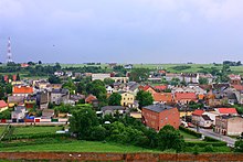
Radzyń Chełmiński [ ˈrad͡zɨɲ xɛu̯ˈmʲiɲskʲi ] ( German Rehden ) is a small town in the powiat Grudziądzki of the Kuyavian-Pomeranian Voivodeship in Poland . It is the seat of the town-and-country municipality of the same name with around 4700 inhabitants.
Geographical location
The city is located in the Kulmerland , south of the Gdańsk Bay , about 37 kilometers (as the crow flies) south of Kwidzyn ( Marienwerder ) and 15 kilometers southeast of Grudziądz ( Graudenz ).
history

The city was built around the middle of the 13th century, near a castle of the Teutonic Order State of Prussia .
Between 1466 and 1772 the city belonged to the autonomous Royal Prussia , which was under Polish patronage, and belonged to the Culm Voivodeship as part of the Culmer Land . As part of the first partition of Poland-Lithuania in 1772 Rehden came to the Kingdom of Prussia . In the last quarter of the 18th century, Rehden Castle was the seat of the Royal Domain Office.
During the French period , Rehden was assigned to the Duchy of Warsaw from 1807 to 1815 . Since the Congress of Vienna , Rehden has belonged under international law to the city and district of Graudenz in the Marienwerder administrative district of the Prussian province of West Prussia , from 1871 to the German Empire . There were two Catholic churches and one Protestant church in the city.
After the end of the First World War , Rehden had to be ceded to the Polish Pomeranian Voivodeship in 1920 due to the provisions of the Versailles Treaty on the establishment of the Polish Corridor . After the attack on Poland in 1939, Rehden returned to the Reich with the Graudenz district and was assigned to the Reichsgau Danzig-West Prussia , to which it belonged until 1945.
Towards the end of World War II , the Red Army occupied the region in the spring of 1945 and Radzyń Chełmiński returned to Poland.
Demographics
| year | population | Remarks |
|---|---|---|
| 1802 | 699 | |
| 1816 | 836 | 189 Evangelicals, 588 Catholics, 59 Jews |
| 1821 | 913 | in 103 private houses |
| 1831 | 981 | half German, half Polish |
| 1852 | 1407 | |
| 1864 | 1692 | 721 Protestants and 806 Catholics |
| 1871 | 1780 | including 750 Evangelicals, 830 Catholics (490 Poles ) |
| 1885 | 1870 | |
| 1905 | 2074 | including 1261 Catholics |
| 1910 | 2010 | on December 1st |
Attractions
- Ruins of the former Rehden Order Castle , which was built in 1234 by the Teutonic Order .
- Former synagogue , built at the end of the 19th century
- Gołębiewo perforated stick, cult stick from the Mesolithic period in the Frater Władysław Łęga Museum in Grudziądz .
local community
The town-and-country community (gmina miejsko-wiejska) Radzyń Chełmiński includes the town and 15 villages with school boards.
literature
- Johann Friedrich Goldbeck : Complete topography of the Kingdom of Prussia . Part II: Topography of West Prussia , Marienwerder 1789, p. 36, no. 5.) .
- August Eduard Preuss : Prussian country and folklore . Königsberg 1835, S. 440, no. 54 .
- Xaver Frölich : History of the Graudenzer Kreis . Volume 1, Graudenz 1868, pp. 243-266.
- Georg Bujack : The Rheden ruins. Sketch from the history of the German order . In: New Prussian Provincial Papers . Volume 3, Königsberg 1866, pp. 200-213.
Web links
Footnotes
- ^ A b Johann Friedrich Goldbeck : Complete topography of the Kingdom of Prussia . Part II: Topography of West Prussia , Marienwerder 1789, p. 36, no. 5.) . Johann Friedrich Goldbeck : Complete topography of the Kingdom of Prussia . Part II: Topography of West Prussia , Marienwerder 1789, p. 36, no. 5.) .
- ↑ Friedrich Gottlob Leonhardi : Earth description of the Prussian monarchy . Volume 1, Halle 1791, pp. 10–11.
- ↑ a b c Alexander August Mützell and Leopold Krug : New topographical-statistical-geographical dictionary of the Prussian state . Volume 5: T – Z , Halle 1823, pp. 360-367, item 575 .
- ^ A b E. Jacobson: Topographical-statistical manual for the administrative district Marienwerder . Danzig 1868, p. 19, no.31.
- ^ August Eduard Preuss : Prussian country and folklore . Königsberg 1835, S. 440, no. 54 .
- ^ Kraatz: Topographical-statistical manual of the Prussian state '. Berlin 1856, p. 502.
- ^ E. Jacobson: Topographical-statistical manual for the administrative district Marienwerder . Danzig 1868, local directory of the Marienwerder administrative district , pp. 24–25, no. 154.
- ^ Gustav Neumann : Geography of the Prussian State . 2nd edition, Volume 2, Berlin 1874, pp. 53-54, item 8.
- ^ Michael Rademacher: German administrative history from the unification of the empire in 1871 to the reunification in 1990. dan_graudenz.html. (Online material for the dissertation, Osnabrück 2006).
- ^ Meyer's Large Conversational Lexicon . 6th edition, Volume 16, Leipzig / Vienna 1908, p. 721 .
- ↑ Community directory of the district of Graudenz 1900 - gemeindeververzeichnis.de
- ↑ Georg Bujack : The ruin Rheden. Sketch from the history of the German order . In: New Prussian Provincial Papers . Volume 3, Königsberg 1866, pp. 200-213.


