Recklingen
|
Recklingen
Flecken Apenburg-Winterfeld
Coordinates: 52 ° 44 ′ 3 ″ N , 11 ° 13 ′ 37 ″ E
|
|
|---|---|
| Height : | 35 m above sea level NHN |
| Area : | 6 km² |
| Residents : | 150 (December 31, 2018) |
| Population density : | 25 inhabitants / km² |
| Incorporation : | 17th October 1973 |
| Incorporated into: | Winter field |
| Postal code : | 38486 |
| Area code : | 039009 |
|
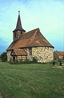
Recklingen village church
|
|
Location of Recklingen in Saxony-Anhalt |
Recklingen is a district of the community Flecken Apenburg-Winterfeld in the Altmarkkreis Salzwedel in Saxony-Anhalt , Germany.
geography
The Altmark village of Recklingen, a street village with a church, is located about 10 kilometers southeast of the district town of Salzwedel . To the north of the village lies the Baarser Mühlengraben, which flows into the Purnitz .
history
As early as 1300 and 1318, the village was owned by the von der Schulenburg family . In 1320 Joannes Rekeling is mentioned in Salzwedel.
In the Landbuch der Mark Brandenburg from 1375 the village Recklingen is listed as Rekelinge . The von der Schulenburg had income here, including from a mill. A mention as Reckling comes from the year 1377, when a knight from the Schulenburg sold the villages of Stappenbeck, Cricheldorf and Reckling . Further mentions are 1687 Reckeling and finally 1804 Recklingen .
During the land reform of 1946, 336.4 hectares were expropriated and divided among 35 settlers. In 1948 there were 35 buyers, 11 of them new settlers. In 1958 the first agricultural production cooperative of type I, the LPG "Voran", was established, which in 1968 was connected to LPG of type III in Winterfeld.
Incorporations
On 25 July 1952, the municipality triangle Lingen was from the district Salzwedel in the circuit blocks reclassified. On October 17, 1973, the Recklingen community was incorporated into the Winterfeld community.
On July 1, 2009, the municipality of Winterfeld merged with other municipalities to form the municipality of Flecken Apenburg-Winterfeld. Recklingen came to Apenburg-Winterfeld as a district on the same day.
Population development
|
|
|
|
Swell:
religion
The Protestant parish of Recklingen belonged to the parish of Apenburg (formerly Groß-Apenburg). Today, the church belongs to the parish area Apenburg the church district Salzwedel in Propst Sprengel Stendal Magdeburg of the Evangelical Church in Central Germany .
Culture and sights
- The Protestant village church in Recklingen is a flat-roofed field stone building with a small half-timbered roof turret . In the 18th and 19th centuries, the original medieval building was heavily modified.
literature
- Peter P. Rohrlach: Historical local lexicon for the Altmark (Historical local lexicon for Brandenburg, Part XII) . Berliner Wissenschafts-Verlag, Berlin 2018, ISBN 978-3-8305-2235-5 , pp. 1749-1752 .
- Wilhelm Zahn : Local history of the Altmark. Edited by Martin Ehlies based on the bequests of the author. 2nd Edition. Verlag Salzwedeler Wochenblatt, Graphische Anstalt, Salzwedel 1928, DNB 578458357 , OCLC 614308966 , p. 125-126 .
- JAF Hermes, MJ Weigelt: Historical-geographical-statistical-topographical handbook from the administrative districts of Magdeburg . Topographical part. Ed .: Verlag Heinrichshofen. tape 2 , 1842, p. 343-344 ( digitized version ).
Web links
Individual evidence
- ↑ a b c d e Peter P. Rohrlach: Historical local lexicon for the Altmark (Historical local lexicon for Brandenburg, Part XII) . Berliner Wissenschafts-Verlag, Berlin 2018, ISBN 978-3-8305-2235-5 , pp. 1749-1752 .
- ↑ a b Verbandsgemeinde Beetzendorf-Diesdorf: residents of the districts on December 31 for 2015 and 2018 . June 6, 2019.
- ↑ Saxony-Anhalt viewer of the State Office for Surveying and Geoinformation ( notes )
- ^ Georg Schmidt : The family from the Schulenburg . 1st part, 1908, p. 258 .
- ^ Adolph Friedrich Riedel : Codex diplomaticus Brandenburgensis : Collection of documents, chronicles and other source documents . Main part 1st volume 14 . Berlin 1857, p. 62 ( digitized version ).
- ↑ Johannes Schultze : The land book of the Mark Brandenburg from 1375 (= Brandenburg land books . Volume 2 ). Commission publisher von Gsellius, Berlin 1940, p. 393 ( uni-potsdam.de ).
- ^ Adolph Friedrich Riedel : Codex diplomaticus Brandenburgensis : Collection of documents, chronicles and other source documents . Main part 1st volume 5 . Berlin 1845, p. 296 ( digitized version ).
- ^ Friedrich Wilhelm August Bratring : Statistical-topographical description of the entire Mark Brandenburg . For statisticians, businessmen, especially for camera operators. Berlin 1804, p. 347 ( digitized version ).
- ↑ Federal Statistical Office (Ed.): Municipalities 1994 and their changes since 01.01.1948 in the new federal states . Metzler-Poeschel, Stuttgart 1995, ISBN 3-8246-0321-7 , pp. 360-362 .
- ^ Wilhelm Zahn : Heimatkunde der Altmark. Edited by Martin Ehlies based on the bequests of the author. 2nd Edition. Verlag Salzwedeler Wochenblatt, Graphische Anstalt, Salzwedel 1928, DNB 578458357 , OCLC 614308966 , p. 125-126 .
- ↑ Parish Almanac or the Protestant clergy and churches of the Province of Saxony in the counties of Wernigerode, Rossla and Stolberg . 19th year, 1903, ZDB -ID 551010-7 , p. 24 ( wiki-de.genealogy.net [accessed December 30, 2017]).
- ^ Apenburg parish area. Retrieved April 14, 2018 .
- ↑ Thomas Hartwig: All Altmark churches from A to Z . Elbe-Havel-Verlag, Havelberg 2012, ISBN 978-3-9814039-5-4 , p. 385 ( limited preview in Google Book Search).

