Restrepo (Valle del Cauca)
| Restrepo | ||
|---|---|---|
|
Coordinates: 3 ° 50 ′ N , 76 ° 32 ′ W Restrepo on the map of Colombia
|
||
|
Location of the municipality of Restrepo in Valle del Cauca
|
||
| Basic data | ||
| Country | Colombia | |
| Department | Valle del Cauca | |
| City foundation | 1913 | |
| Residents | 16,410 (2019) | |
| City insignia | ||
| Detailed data | ||
| surface | 237 km 2 | |
| Population density | 69 people / km 2 | |
| height | 1400 m | |
| Time zone | UTC -5 | |
| City Presidency | Armando Vélez Vélez (2019-2022) | |
| Website | ||
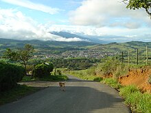
| View of Restrepo | ||
Restrepo is a commune ( municipality ) in the department of Valle del Cauca in Colombia .
General data
- Foundation: December 1, 1913.
- Founders: Julio Fernández Medina, Anselmo Rendón, Nicanor Grisales and other colonists.
- Parish since: April 3, 1925.
- Height: Approx. 1400 meters above sea level
- Extension: 237 km²
- Average temperature: 21 ° C.
- Population: 16,410, of which 9259 in the urban part of the municipality's cabecera municipal (as of 2019)
- Distance to Santiago de Cali : 90 kilometers.
- Name of the inhabitants: Restrepeños.
- Geography: Mostly mountainous.
- Main parts: El Diamante, Ilama, Madroñal and San Salvador.
mayor
- 1987–1989 Roberto Arbeláez Restrepo
- 1990-1992 Gilberto Ossa Betancourt
- 1993-1995 Aldemar Marin Aguirre
- 1996-1998 Ovidio Arturo Marin Cuevas
- 1999–2001 Jesús Alberto Ospina Rendón
- 2002-2004 Alberto Cardona Gordillo
- 2005-2007 Arley Ospina Noreña
- 2008–2011 Maria Saider Valencia de Echeverry
- 2012–2015 Luis Carlos Ossa Morales
- 2016–2019 Edilson Navia Ortega
- 2019–2022 Armando Velez Velez
Culture and history
The western Cordillera ( Andes ) was gradually populated by emigrants from Antioquia , Cauca , Boyacá and Nariño between 1900 and 1940 . This process is known by scholars as late colonization. The establishment of Restrepo in 1913 marked the beginning of the colonization of the Calima and Río Bravo areas.
There were two major groups of settlers:
- Refugees from the Guerra de Los Mil Días war who migrated south from Antioquia for protection and a better life.
- Settlers with the certainty of upgrading the site by colonizing the Restrepo area, which at that time belonged to Manuel Escobar Torres, Liborio Vergara and Julio Fernández Medina.
The latter, when he noticed the intention of the settlers to found a village under the leadership of Capitán Anselmo Rendón, he offered them the worst terrain in a part called El Transitio.
With the establishment of a village, land prices in this region have increased. This increase caused litigation between the settlers who previously parceled and worked wasteland. This conflict brought about unscrupulous lawyers, traders and others.
In the forty years of slow but constant settlement in the Restrepo region, there was another notable event:
This region was inhabited by wealthy Indians before the arrival of the Spaniards. The Calima region remained undiscovered until the end of the 19th century. Due to the late settlement, there was no looting by the Spaniards. Some settlers discovered Indian graves with grave goods made of pure gold.
With no attention to secrecy, the news quickly spread and the region was ravaged by adventurers and prospectors. There were confrontations with the settlers.
With the gold they found, many of these prospectors bought land from the settlers and established themselves as landowners.
A group of treasure hunters known as Los Rendones discovered a hidden treasure in the finca of a woman named Maxima in Vereda La Italia. According to the custom of this period, the treasure was exhibited in Don Marcelino Betancourt's shop.
economy
Until the end of the 20th century, the economy of Restrepo was mainly determined by the cultivation of coffee. This was the "Bonanza Cafetera". Due to the drop in the price of coffee and the rise in wages of the workers (trabajadores), the cultivation of coffee became more and more uneconomical. Many coffee plantations have been cleared and converted into pastureland. The main industries at the moment are livestock and pineapple cultivation.
Attractions
Restrepo attractions include:
- The Iglesia Nuestra Señora del Carmen church
- The La Rochela amusement park
- The Cascada Río Bravo waterfall
- Museum Casa de la cultura Ovidio Arturo Marin Cuevas
- House of culture Casa de la Cultura
- The Finca Rancho Grande
- The lake Lago Calima
Neighboring communities
To the north Yotoco and Calima Darién . To the south Vijes and La Cumbre . To the east Yotoco and Vijes. To the west La Cumbre and Dagua .
Districts
Restrepo has the following districts:
|
|
|
Veredas
Restrepo has the following veredas:
|
Corregimientos
Restrepo has the following corregimientos:
- El Agrado
- El Diamante
- La Palma
- Madroñal
- Rio Bravo
- novel
- San Salvador
- Tres Puertas
Personalities
- Miguel Ángel Mejía Múnera (El Loco) (Los Mellizos)
- Víctor Manuel Mejía Múnera (Los Mellizos)
- Ovidio Athuro Marin Cuevas (Ex-Mayor)
Web links
- Alcaldía Restrepo Valle Cauca. Alcaldía de Restrepo - Valle del Cauca, accessed on May 2, 2019 (Spanish, website of the municipality of Restrepo).
Individual evidence
- ↑ a b c Nuestro municipio. Alcaldía de Restrepo - Valle del Cauca, accessed on May 2, 2019 (Spanish, information on the municipality).
- ↑ ESTIMACIONES DE POBLACIÓN 1985 - 2005 Y PROYECCIONES DE POBLACIÓN 2005 - 2020 TOTAL DEPARTAMENTAL POR ÁREA. (Excel; 1.72 MB) DANE, May 11, 2011, accessed on May 2, 2019 (Spanish, extrapolation of the population of Colombia).
- ↑ http://www.restrepo-valle.gov.co/nuestromunicipio.shtml?apc=m1I1--&m=t#Corregimiento ( page no longer available , search in web archives ) Info: The link was automatically marked as defective. Please check the link according to the instructions and then remove this notice.


