La Unión (Valle del Cauca)
| La Unión | ||
|---|---|---|
|
Coordinates: 4 ° 32 ' N , 76 ° 6' W La Unión on the map of Colombia
|
||
|
Location of the municipality of La Unión in Valle del Cauca
|
||
| Basic data | ||
| Country | Colombia | |
| Department | Valle del Cauca | |
| City foundation | 1604 | |
| Residents | 40,339 (2019) | |
| City insignia | ||
| Detailed data | ||
| surface | 125 km 2 | |
| Population density | 323 people / km 2 | |
| height | 975 m | |
| Waters | Río Cauca | |
| Time zone | UTC -5 | |
| City Presidency | Julián Hernández (2016-2019) | |
| Website | ||
| Church in La Unión | ||
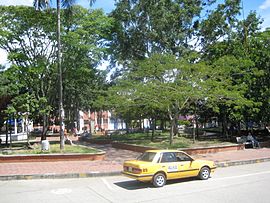
| Place in La Unión | ||
La Unión is a municipality ( municipality ) in the department of Valle del Cauca in Colombia .
geography
La Unión is located on the Río Cauca in the sub-region Norte in Valle del Cauca at an altitude of 975 m above sea level. NN , 163 km from Cali and has an average annual temperature of 24 ° C. The municipality borders on Toro to the north, Roldanillo to the south, El Dovio and Versalles to the west and La Victoria and Obando to the east .
population
The municipality of La Unión has 40,339 inhabitants, of which 31,890 live in the urban part (cabecera municipal) of the municipality (as of 2019).
history
La Unión was founded in 1604 and was built around a hacienda . The place received a main square in 1796. Due to administrative problems as a result of various wars in the 19th century, it was officially founded again in 1880. La Unión has had parish status since 1890. A previous name of the municipality is Hato de Lemos .
economy
The main industry in La Unión is agriculture . In addition, cattle and poultry production , handicrafts , mining , tourism and trade play an important role.
See also
Web links
- Alcaldía Municipal de La Unión Valle Del Cauca. Alcaldía de La Unión - Valle del Cauca, accessed on May 2, 2019 (Spanish, website of the municipality of La Unión).
Individual evidence
- ↑ a b Information on the community (Spanish) ( Memento from December 22, 2016 in the Internet Archive )
- ↑ ESTIMACIONES DE POBLACIÓN 1985 - 2005 Y PROYECCIONES DE POBLACIÓN 2005 - 2020 TOTAL DEPARTAMENTAL POR ÁREA. (Excel; 1.72 MB) DANE, May 11, 2011, accessed on May 2, 2019 (Spanish, extrapolation of the population of Colombia).
- ↑ Historia. Alcaldía de La Unión - Valle del Cauca, accessed on May 2, 2019 (Spanish, information on the history of the municipality).


