
Rhine ports of Karlsruhe
| Rhine ports of Karlsruhe | |||
|---|---|---|---|
| Data | |||
| UN / LOCODE | DE KAE | ||
| owner | City of Karlsruhe, federal government | ||
| operator | KVVH GmbH , MiRO GmbH and others | ||
| Port type | port | ||
| Throughput | 6 million tons (2011) | ||
| website | http://www.rheinhafen.de/rheinhaefen-karlsruhe/ | ||
| Geographic information | |||
| place | Karlsruhe | ||
| country | Baden-Württemberg | ||
| Country | Germany | ||
.jpg) |
|||
| Coordinates | 49 ° 4 '12 " N , 8 ° 19' 48" E | ||
|
|||

The Rhine ports of Karlsruhe are the ports of the city of Karlsruhe , on the Upper Rhine , Baden-Württemberg .
geography
The ports are located on the right bank of the Rhine at the following spatially separate locations at an altitude of 100 to 115 m above sea level. NN .
- Rhine km 367.5 R: Oil port (large commercial shipping)
- Rhine km 362.7 R: Maxau harbor
- Rhine km 359.9 R: Rheinhafen Karlsruhe (large commercial shipping)
history

At the beginning of the 19th century, plans began to connect the city to the Rhine by a canal. Port facilities were planned near today's city center. The execution had to be omitted because of the enormous costs (barrages and long distance for the Rhine connection). Only in 1901 could two docks and a small oil basin be put into operation at the present location. Damage in the Second World War was repaired in the early 1950s and in 1957 construction of the oil port began.
Locations
Oil port

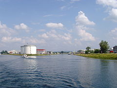
The oil port was built between 1957 and 1963 when two refineries were built on the Rhine to the northwest of Karlsruhe . The size of the industrial area is 43 hectares, of which 35 hectares are water surface with two kilometers of quays developed for handling purposes. These two companies were in constant competition. Therefore, they supplied themselves with almost no raw, semi-finished or finished products. As a result, one refinery purchased these products by ship and the other shipped them - for example to and from Rotterdam. With an annual turnover of up to 12 million tons, Karlsruhe was the number two in Germany, behind Duisburg-Ruhrort , which is Germany's most heavily handled inland port with around 50 million tons. After the refineries merged to form the Oberrhein mineral oil refinery in the 1990s, handling at the oil port fell from eight to ten million tons to around three to four million, while handling at the Rhine port remained the same at three to four million tons. The infrastructure in the oil port has six loading bays for mineral oil, pumps and a handling facility for liquid gas . The oil port has storage capacity for almost five million cubic meters of various types of liquid goods. The port itself does not have a siding; one only exists indirectly via the refinery.
Maxau harbor
In 1862 the port of Maxau became the closest port for supplying the city of Karlsruhe after being dredged at the city's expense. With the opening of the Rhine port in Karlsruhe, the Maxau port lost its importance in 1901. Today it is largely used as a marina . There is also transshipment for the directly adjacent Stora Enso paper mill . The WSA , outskirts of Karlsruhe, is located in the north-eastern section and operates its own jetty for its service boats and workboats there . At this site, which is also at Rhine kilometer 362.3 R Maxau determined.
Rheinhafen Karlsruhe

This port went into operation in 1901. It consists of six harbor basins with 71 hectares of water. Five are laid out like the fingers of a hand. Basin six, previously just a narrow canal , represents the connection to the Rhine. Among other things, a large container terminal is located at this basin , where the largest ships on the Rhine - single ships up to 135 meters in length and push convoys up to 180 meters in length - moor. They connect Karlsruhe with the major seaports on the Rhine-Maas Delta in regular services. Coal handling is also still of great importance, mainly for the large Rheinhafen steam power plant of Energie Baden-Württemberg (EnBW) located right at the port entrance . All other bulk goods are also handled at the Karlsruhe Rheinhafen. Three of the world's leading companies trading in ferrous, steel and non-ferrous scrap metal can be found on the approximately 300- hectare site, as well as three concrete plants that receive their raw materials by ship. There are almost seven kilometers of quays available for transshipment purposes with a length of 14 km of shore and are provided with siding. Crane handling is possible on five kilometers of shore. There are 19 unloaders portal and cranes with a capacity 4-25 t, two container cranes with 50 t capacity, cranes from 20 to 250 t, conveyor belts and industrial trucks . There are 65 hectares of open-air storage space, 22 hectares of indoor or covered storage space, silos with 7,000 m³ and grain stores with a capacity of 25,000 t as well as tank farms for 335,000 m³. The WSP Karlsruhe station is located in Nordbeckenstraße .
Flood barrier
Since 1987 there has been a 40 meter wide and nine meter high barrier gate with a pedestrian bridge at the port entrance. If the level Maxau the high water mark reached II and set the navigation is (level 7.50 meters), lowers the gate and thus closes the gap between the dams on both sides of the port. In this way, the facilities in the port are protected against flooding and the risks to the environment are reduced.
Port railway
The port railway was created around 1900 and, with over 40 km of track, opens up the Rhine port of Karlsruhe . Access is from the Karlsruhe-West train station on the Winden – Karlsruhe line and the Karlsruhe freight bypass . In 2007, the facilities as industrial main tracks from the first switch west of the Albbrücke, which until then had been operated half by KVVH and DB AG or their legal predecessors, were completely taken over by KVVH, while the track to Karlsruhe-West station as previously owned by DB AG alone.
No rolling stock (wagons, locomotives, etc.) is kept available.
Passenger shipping
The Karlsruhe passenger ship is berthed at the end of Basin II .
Sports
At the end of the north basin there is the clubhouse and jetty of the rowing club “ Karlsruher Rheinklub Alemannia ”, as well as the office of the Baden regional association of the German Life Saving Society ( DLRG ). At the end of basin IV are the club houses of the "Karlsruher Ruderverein Wiking von 1879", as well as the canoe racing of the " Rheinbrüder Karlsruhe eV".
traffic
The Karlsruhe harbors are accessible via local roads leading to Bundesstraße 10 . Track branches of KVVH from Bahnhof Karlsruhe West at maxau railway connected to the railway network, the harbor Maxau and oil plants are connected thereto.

Flood gate seen from the harbor side

Closed flood gate

Quay with railroad track
Basin V (2009)

the Karlsruhe

Cranes on Werftstrasse


.jpg)
.jpg)

Web links
Individual evidence
- ^ Ports of Karlsruhe, history
- ^ Infrastructure of the Karlsruhe oil port
- ↑ Marina with aerial view
- ↑ Maxau gauge ( Memento of the original from November 23, 2015 in the Internet Archive ) Info: The archive link was automatically inserted and not yet checked. Please check the original and archive link according to the instructions and then remove this notice.
- ^ Infrastructure Rheinhafen Karlsruhe
- ↑ Flood protection
- ↑ Hafenbahn Karlsruhe ( Memento of the original from February 10, 2016 in the Internet Archive ) Info: The archive link was inserted automatically and has not yet been checked. Please check the original and archive link according to the instructions and then remove this notice.