Rogglfing (Dorfen)
|
Rogglfing
City of Dorfen
Coordinates: 48 ° 17 '11 " N , 12 ° 4' 42" E
|
|
|---|---|
| Height : | 500 m above sea level NHN |
| Residents : | 20th |
| Postal code : | 84405 |
| Area code : | 08081 |
|
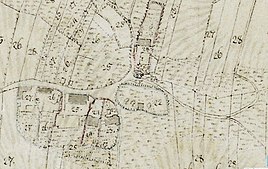
Rogglfing in the 19th century
|
|
The village of Rogglfing is a north-western part of the town of Dorfen in the Upper Bavarian district of Erding . The village with around 20 inhabitants comprises six properties, some of which are farms.
geography
Rogglfing is protected at 500 meters above sea level in a depression between the valley of the great Vils and the Isental . In the south the village is enclosed by the Rogglfinger Forest. In the west by the Moosbach lies the Rogglfinger Moos with its 3 fish ponds, a drained part of the Erdinger moorland where peat was extracted on a small scale in the past . The origins of two of the three source brooks of the Seebach , which flows into the Isen in Niederham (on the outskirts of Dorfen), are between Rogglfing and the neighboring village of Landersdorf to the northeast .
In the northeast, about 850 m away, is Landersdorf . Schmidham is about 1 km away in the southeast . To the south is about 700 meters away in the forest, the village wood . Shaftlding (Lengdorf) with its district Nodering is 650 m away in the northwest. In the north of Rogglfing about 1 km as the crow flies on the other side of the state road Schrafstetten (Tfk / Vils) .
history
Rogglfing is on the Erding-Dorfen-Mühldorf trade route. The first settlements in the vicinity of today's town existed in prehistory and early history. At the latest in the early Middle Ages, a village developed in Rogglfing that was assigned to the Freising Monastery. The oldest property in Rogglfing is probably house number 6, which according to the Bavarian tradition of the house name today forms the official district of "Lang". There is also the guest house of the same name "Beim Lang z 'Rogglfing".
During the air raids on Munich by the victorious Allied powers , a bomber near Dorfen suffered an engine failure. Before his emergency landing, he dropped his cargo, two aerial bombs destined for Munich, over the area of the Rogglfinger Wald. One of the two bomb craters was filled with rubble over the decades. The remains of the second crater are still present as a pond.
Under President Ronald Reagan , the Army used the forest behind Rogglfing for one summer as a military training area to prepare GIs who had just returned from the Vietnam War for the defense of the Federal Republic on the border with the GDR .
Between 1818 and 1978 Rogglfing belonged to the municipality of Zeilhofen . Since the regional reform in Bavaria , it has been part of the city of Dorfen and borders the municipality of Lengdorf and the municipality of Taufkirchen (Vils) .
traffic
State road 2084 Erding – Dorfen runs 60 meters north of Rogglfing . 3 kilometers away is located in the municipality Lengdorf the Thann-Matzbach station . Lengdorf can be reached by car in five minutes via the forest road at the south-western end of the village, and from autumn 2019 also to the A 94 motorway exit Lengdorf . A cycle path also connects Rogglfing with the neighboring village of Landersdorf and there is a connection to Esterndorf and Zeilhofen via Feldstrasse .
Individual evidence
- ↑ Welcome | District of Erding. Retrieved November 21, 2018 .
- ^ Drainage of the Erdinger Moos - Historisches Lexikon Bayerns. Retrieved on November 21, 2018 (German (Sie-Salutation)).
- ^ BayernAtlas. Retrieved November 21, 2018 .
- ↑ a b Dorfener Heimatbuch Volume 1 . 2006.
literature
- Dorfener Heimatbuch. From the city elevation to the 3rd millennium. Volume 1, Präbst printing house, Dorfen 2006. (not evaluated)


