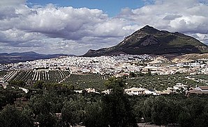
Rod (Cordoba)
| Parish of Rute | ||
|---|---|---|

|
||
| coat of arms | Map of Spain | |

|
|
|
| Basic data | ||
| Autonomous Community : | Andalusia | |
| Province : | Cordoba | |
| Comarca : | Subbética cordobesa | |
| Coordinates | 37 ° 20 ′ N , 4 ° 22 ′ W | |
| Area : | 132.4 km² | |
| Residents : | 9,845 (Jan 1, 2019) | |
| Population density : | 74.36 inhabitants / km² | |
| Postal code : | 14940 | |
| Municipality number ( INE ): | 14058 | |
| administration | ||
| Website : | www.rute.es | |
Rute is a Spanish municipality in the province of Cordoba in Andalusia .
location
The place extends over an area of 132 km² and is 94 kilometers from the provincial capital of Cordoba . The closest localities are Cuevas de San Marcos in the southwest, Lucena in the northwest and La Lagunillas in the east.
Web links
Commons : Rute, Córdoba - Collection of images, videos and audio files
Individual evidence
- ↑ Cifras oficiales de población resultantes de la revisión del Padrón municipal a 1 de enero . Population statistics from the Instituto Nacional de Estadística (population update).
