STS-59
| Mission emblem | |||
|---|---|---|---|

|
|||
| Mission dates | |||
| Mission: | STS-59 | ||
| COSPAR-ID : | 1994-020A | ||
| Crew: | 6th | ||
| Begin: | April 9, 1994, 11:05:00 UTC | ||
| Starting place: | Kennedy Space Center , LC-39A | ||
| Landing: | April 20, 1994, 16:54:29 UTC | ||
| Landing place: | Edwards Air Force Base, Runway 22 | ||
| Flight duration: | 11d 5h 49min 29s | ||
| Earth orbits: | 183 | ||
| Rotation time : | 88.7 min | ||
| Orbit inclination : | 56.9 ° | ||
| Apogee : | 218 km | ||
| Perigee : | 204 km | ||
| Covered track: | 7.6 million km | ||
| Payload: | Space Radar Laboratory (SRL-1) | ||
| Team photo | |||
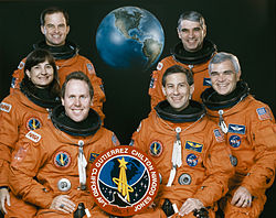
 v. l. No. Front: Thomas Jones, Jay Apt; Middle: Linda Godwin, Michael Clifford; Back: Kevin Chilton, Sidney Gutierrez |
|||
| ◄ Before / After ► | |||
|
|||
STS-59 ( english S pace T ransportation S ystem) is a mission designation for the US Space Shuttle Endeavor (OV-105) of NASA . The launch took place on April 9, 1994. It was the 62nd space shuttle mission and the sixth flight of the space shuttle Endeavor.
team
- Sidney Gutierrez (2nd space flight), commander
- Kevin Chilton (2nd spaceflight), pilot
- Linda Godwin (2nd spaceflight), mission specialist
- Jerome Apt (3rd space flight), mission specialist
- Michael Clifford (2nd spaceflight), mission specialist
- Thomas Jones (1st spaceflight), mission specialist
Mission history
On its sixth flight, the Endeavor put Space Radar Laboratory 1 into orbit. It was housed in the shuttle's payload bay, which almost completely filled it. Three radar devices and another measuring complex were part of the scientific equipment. The Space Imaging Radar (SIR-C) consisted of two 11.8 m long antennas, which transmitted signals with the wavelengths 23.5 cm and 5.8 cm and received their echoes. For the first time, the radar waves were polarized both horizontally and vertically. The measurements were supplemented by the X-SAR (X-Band Synthetic Aperture Radar) system developed in Europe, which worked with a wavelength of 3.1 cm. Statements about the surface properties of the earth can be obtained from the changes in the reflected waves.
The objectives of the mission were the creation of new maps, the search for mineral resources and, above all, ecological knowledge of around 4000 different areas. These ranged from the snow-covered slopes of the Ötztal Alps to the American Mammoth Mountains, the Bolivian Andes and the Bermuda Islands to Russian forests, deserts of the Sahel zone and Australian bush. A wide variety of formations were examined: mountain regions, marine areas, primeval forests, deserts, large cities, agricultural areas, industrial regions and volcanoes. A total of 12% of the earth's surface was covered, including a quarter of the total land mass of our planet. The data was recorded on board the space shuttle. From this, multicolored images were later put together, which have a high resolution and allow statements about soil conditions, soil moisture and vegetation . Overview data were transmitted to a ground station during the flight. In addition, 14,000 photos of the regions concerned were taken. In the meantime, scientists collected comparative data in 19 reference areas on Earth.
During the entire flight, the measurement complex MAPS (Measurement of Air Pollution from Space) was used to determine the carbon monoxide concentration in the lower atmosphere (troposphere). These data are intended to provide information on how the natural breakdown of greenhouse gases takes place. Further experiments on board the Endeavor concerned the loss of tissue in weightlessness and the effectiveness of physical training with a bicycle ergometer. The STS-59 astronauts had radio contact with US schools, Russian and US space travelers on the ground and in the Mir space station several times .
Getaway Special experiments were in the hold on board the space shuttle . These were developed by selected students in St. Louis and the results were sent back to them after the mission was completed.
During the first activation of the X-SAR, ground control reported that they would not be able to fully activate the amplifiers that supplied power to the instrument. The problem was that the electrical voltage inside the amplifier was too low. However, the engineers could not explain the cause of the problem, so they took the amplifiers off the grid for three hours. As it turned out later, the problem was that the circuit protection, a kind of electrical fuse, was set too sensitively . The engineers of the laboratory bypassed the fuse and switched the instruments on again, which then ran without further incidents.
Towards the end of the mission, the flight was extended by one day due to sufficient reserves. Subsequently, due to bad weather in Florida, it was necessary to postpone the landing again. After an eleven-day flight, the Endeavor had to land in California. The data of the flight is so extensive that it would fill twenty thousand encyclopedias.
See also
Web links
- NASA Mission overview (English)
- Video summary with comments of the crew (English)
- STS-59 in the Encyclopedia Astronautica (English)
