
STS-99
| Mission emblem | |||
|---|---|---|---|

|
|||
| Mission dates | |||
| Mission: | STS-99 | ||
| COSPAR-ID : | 2000-010A | ||
| Crew: | 6th | ||
| Begin: | February 11, 2000, 17:43:40 UTC | ||
| Starting place: | Kennedy Space Center , LC-39A | ||
| Landing: | February 22, 2000, 23:22:30 UTC | ||
| Landing place: | Kennedy Space Center, Lane 33 | ||
| Flight duration: | 11d 5h 38min 50s | ||
| Earth orbits: | 181 | ||
| Rotation time : | 89.2 min | ||
| Orbit inclination : | 57.0 ° | ||
| Apogee : | 242 km | ||
| Perigee : | 224 km | ||
| Covered track: | 7.6 million km | ||
| Team photo | |||
 v. l. No. sitting in front: Mamoru Mōri, Gerhard Thiele; standing in the back: Janice Voss, Kevin Kregel, Dominic Gorie, Janet Kavandi |
|||
| ◄ Before / After ► | |||
|
|||
STS-99 ( English Space Transportation System) is the mission name for the Shuttle Radar Topography Mission ( SRTM ), a flight of the US Space Shuttle Endeavor (OV-105) of NASA for the purpose of creation of radar-based remote sensing of the earth's surface. The launch took place on February 11, 2000. It was the 97th space shuttle mission and the 14th flight of the space shuttle Endeavor.
team
- Kevin Kregel (4th space flight), commander
- Dominic Gorie (2nd space flight), pilot
- Janet Kavandi (2nd spaceflight), mission specialist
- Janice Voss (5th spaceflight), mission specialist
-
Mamoru Mōri (2nd space flight), Mission Specialist ( NASDA / Japan )

-
Gerhard Thiele (1st space flight), mission specialist ( ESA / Germany )


Mission goal

The aim of the Shuttle Radar Topography Mission was to map the height of the earth's surface between 60 ° north and 58 ° south latitude - the habitat of 95% of the earth's population - using an active radar system ( Synthetic Aperture Radar , SAR). A highly accurate elevation model of the earth could later be calculated from the SRTM data obtained in this way.
The achieved (relative) accuracy of the height support points is specified as ± 6 m and is freely available with a grid width of approx. 30 × 30 m for North America and 90 × 90 m for the rest of the world. Such an accurate elevation model is useful in various applications in cartography , hydrography , air navigation, or radio wave propagation .
Elevation models of this type are also used in the control of guided missiles - therefore the published data have a reduced spatial resolution, while the more finely rasterized elevation values (approx. 30 × 30 m) were handled as secret data and were primarily accessible to the US military. Since 2015, the grids in 30 × 30 m resolution have also been freely available and usable.
mission

In orbit (orbit height approx. 233 km) a 60 m long mast (at that time it was the largest man-made structure in space) was extended from the loading hatch of the shuttle. In the shuttle cargo hold and at the end of the mast there were antennas for receiving the reflections of the signals from the transmitter, which was also installed in the cargo hold.
During the overflight over land areas, the transmitter sent radar waves in the C and X bands to earth. The backscattered signals were picked up by the mast antenna and the on-board antenna. By evaluating the minimum transit time differences of the received signals, which arise transversely to the flight direction due to the distance between the antennas and in flight direction due to the movement of the shuttle, the elevation model of the earth's surface could later be generated ( radar interferometry ).
At the bottom were several teams in action that the world during the mission corner reflectors had to align exactly on the shuttle (corner reflectors). This enabled the data to be georeferenced later. For this purpose, several corner reflectors were set up around the world in the crossing areas of the ascending and descending lanes.
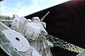
Loading bay of the shuttle during the mission, in the foreground the bucket with the boom behind it the radar antenna

The boom with the second radar antenna at the end

Corner reflector at the DLR in Oberpfaffenhofen


| Costs: | approx. US $ 220 million (US $ 50 million from DLR ) |
| Total weight of the antenna system: | approx. 13.6 tons |
| Mapped land area: | 80% |
SRTM was a joint project of NASA (USA), NIMA (USA), DLR (Germany) and ASI (Italy).
Technical details
| Radar systems: | SIR-C | X-SAR |
|---|---|---|
| Development: | JPL - Jet Propulsion Laboratory | Dornier Satellitensysteme GmbH |
| Board antennas: | 12 m * 80 cm | 12 m * 40 cm |
| Outboard antennas: | 8 m * 80 cm | 6 m * 40 cm |
| Wavelength: | 5.6 cm | 3.1 cm |
| Frequency: | 5.3 GHz | 9.6 GHz |
| Horizontal resolution: | 30 m | 30 m |
| Height resolution: | 10 m | 6 m |
| Width of the pick-up strip: | 225 km | 50 km |
| Mapped land area: | 100% | 40% |
| Data rate: | 180 Mbit / sec | 90 Mbit / sec |
| Amount of data: | 8.6 terabytes | 3.7 terabytes |
The preparation of all data took two years.
See also
Web links
- NASA Mission overview (English)
- Video summary with comments of the crew (English)
- NASA website of the Mission (English)
- NASA video of Mission (English)
- SRTM website at JPL (English)
- Server with the SRTM data (English)
- DLR SRTM website

1 · 2 · 3 · 4 · 5 · 6 · 7 · 8 · 9 · 41-B · 41-C · 41-D · 41-G · 51-A · 51-C · 51-D · 51-B · 51-G · 51-F · 51-I · 51-J · 61-A · 61-B · 61-C · 51-L · 26 · 27 · 29 · 30 · 28 · 34 · 33 · 32 · 36 · 31 · 41 · 38 · 35 · 37 · 39 · 40 · 43 · 48 · 44 · 42 · 45 · 49 · 50 · 46 · 47 · 52 · 53 · 54 · 56 · 55 · 57 · 51 · 58 · 61 · 60 · 62 · 59 · 65 · 64 · 68 · 66 · 63 · 67 · 71 · 70 · 69 · 73 · 74 · 72 · 75 · 76 · 77 · 78 · 79 · 80 · 81 · 82 · 83 · 84 · 94 · 85 · 86 · 87 · 89 · 90 · 91 · 95 · 88 · 96 · 93 · 103 · 99 · 101 · 106 · 92 · 97 · 98 · 102 · 100 · 104 · 105 · 108 · 109 · 110 · 111 · 112 · 113 · 107 · 114 · 121 · 115 · 116 · 117 · 118 · 120 · 122 · 123 · 124 · 126 · 119 · 125 · 127 · 128 · 129 · 130 · 131 · 132 · 133 · 134 · 135