Salza (Saale)
|
Salza Salzke |
||
|
The catchment area of the Salza with the two main arms Querne / Weida (S) and Böse Sieben (N) as well as Süßem, Binder- and Kernersee |
||
| Data | ||
| Water code | EN : 5672 | |
| location | Saxony-Anhalt , Germany | |
| River system | Elbe | |
| Drain over | Saale → Elbe → North Sea | |
| origin | Pumping water from the Kernersee into the Querne / Weida 51 ° 28 ′ 45 ″ N , 11 ° 44 ′ 39 ″ E |
|
| Source height | 85.4 m above sea level NHN | |
| muzzle | At Salzmünde in the Saale Coordinates: 51 ° 31 ′ 46 " N , 11 ° 49 ′ 59" E 51 ° 31 ′ 46 " N , 11 ° 49 ′ 59" E |
|
| Mouth height | 70.9 m above sea level NHN | |
| Height difference | 14.5 m | |
| Bottom slope | 1.3 ‰ | |
| length | 10.8 km (with Querne / Weida: 48.2 km) |
|
| Catchment area | 568 km² | |
| Discharge at the gauge Zappendorf A Eo : 547 km² |
NNQ MNQ MQ Mq MHQ HHQ |
110 l / s 315 l / s 991 l / s 1.8 l / (s km²) 3.52 m³ / s 7.56 m³ / s |
| Left tributaries | Wellbach , Laweke | |
| Right tributaries | Would | |
| Communities | Mansfelder Land lake area , Salzatal | |
|
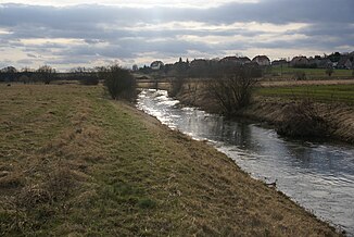
The Salza near Zappendorf |
||
The Salza , also called Salzke , is a left tributary of the Saale in Saxony-Anhalt . It is created on the eastern edge of the Mansfeld-Südharz district by the confluence of the Querne / Weida coming from Querfurt with the Böse Sieben coming from Eisleben , from the left, and runs under this name almost entirely in the Saalekreis . Here, the water of the evil seven does not flow naturally downhill towards the Weida, but is from the 78.7 m above sea level. NHN high Kernersee to the height of 85.4 m above sea level. NHN pumped and fed to this.
With a discharge of only 1.8 l / (km² · s), the Salza river system is one of the most arid in Germany in relation to the size of its catchment area.
course
The Salza by name begins at the point where the Weida, west of Langenbogen, is supplied with the water raised by the Evil Sieben ; it previously flowed through the Süßen Lake , the town of Seeburg , the Bindersee and the Kernersee . After a first short run to Langenbogen to the east, it flows all in all to the northeast. In Köllme it is fed from the right by the Würdebach , in the main town of Zappendorf then from the left by the Laweke , before it flows into the Saale at Salzmünde .
Catchment area and tributaries
The catchment area of the Salza ( river code number 5672) is divided into the following sub- catchment areas (straight end digits correspond to nominal tributaries, the lengths and sub- catchment areas in brackets ):
- 56721–56723 Querne / Weida (37.4 km; 242.9 km²)
- 56721 Querne (16.9 km; 65.5 km², hydrographic upper reaches of the Salza)
- 56722 Weidenbach (41.6 km²)
- 56723 Weida (16.5 km + 4.0 km as a central ditch; 135.8 km², hydrographically second section of the Salza)
- 56724 Bad Seven (167.9 km²)
- 56725-56729 Salza (10.8 km; 122.9 km², a total of 568.0 km²)
Origin of name
The basic word was originally aha (a variant of -au ). This was already weakened to -a in 979, the time of the first documentary mention . There was also the old or Middle High German salt , which stands for salt. Salza means salty water.
environment
For a long time, the adjacent industrial plants - including in particular sugar factories - heavily polluted the stream bed with their sewage. With the decline of local industry, the water quality has improved significantly. The regeneration of the ecosystem is promoted by artificially created biotopes along the Salza.
The Salza flows through to its full length named after her conservation area Salzatal .
Attractions
The Mansfeld Lakes wine route runs along the stream through a branch of the northernmost German wine-growing region, Saale-Unstrut .
Individual evidence
- ↑ a b c d e Map services of the Federal Agency for Nature Conservation ( information )
- ↑ Framework plan for the creation of a maintenance and development concept for the Salza, Laweke and Würdebach - working group Hallesche Auenwälder (PDF, 100 kB)
-
↑ a b c The length of the Salza including Weida and Querne of 48.2 km, of which 10.8 km as Salza by name, was measured in the
Saxony-Anhalt Viewer of the State Office for Surveying and Geoinformation ( notes )
from the origin shown on the map at Kreisstraße 2273; 16.9 km to the transverse up to the inflow of the Weidenbach , of which 1.1 km west of the Ziegelroda Forest and shown as only temporarily carrying water; 16.5 km are accounted for by the Weida by name , 4.0 km by the part of the Mittelgraben fed by the Weida and 10.8 km by the Salza by name from the inflow of the Böse Sieben . - ↑ a b Basic hydrological studies in the Salza catchment area (PDF; 800 kB)
- ↑ Halle and the Saale: the interdependence of the 1200-year-old city with its surrounding area ...
- ↑ Elfriede Ulbricht: The river basin of the Thuringian Saale . 1st edition. Max Niemeyer, Halle (Saale) 1957.
- ↑ Protected areas in Saxony-Anhalt (PDF; 26 kB)

