Saxtons River (Village)
| Saxtons River | ||
|---|---|---|
 Street in the village |
||
| Location in Vermont | ||
|
|
||
| Basic data | ||
| Foundation : | 1905 | |
| State : | United States | |
| State : | Vermont | |
| County : | Windham County | |
| Coordinates : | 43 ° 8 ′ N , 72 ° 31 ′ W | |
| Time zone : | Eastern ( UTC − 5 / −4 ) | |
| Residents : | 565 (as of 2010) | |
| Population density : | 434.6 inhabitants per km 2 | |
| Area : | 1.3 km 2 (approx. 1 mi 2 ) of which 1.3 km 2 (approx. 1 mi 2 ) is land |
|
| Height : | 144 m | |
| Postal code : | 05154 | |
| Area code : | +1 802 | |
| FIPS : | 50-62950 | |
| GNIS ID : | 1459397 | |
| Website : | RockBF.org | |
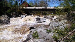
 Saxtons River Falls |
||
Saxtons River is a village in the town of Rockingham in Windham County , Vermont in the United States with 565 inhabitants (according to the 2010 census). Saxtons River is located in the south of the town of Rockingham and is traversed by the Saxtons River in an easterly direction. The Saxtons River Falls are located in Saxtons River.
history
The town of Rockingham, in which the Village Saxtons River is located, is one of the early settled areas of Vermont. Proposed for settlement by Governor Benning Wentworth of New Hampshire, the first settlers came to the country as early as 1753. The village was able to develop thanks to its favorable location on the Saxtons River, whose water drove several water mills in the early 19th century. Early businesses included wool and sawmills, a flour mill, a tannery, a distillery, a watch factory, and a hotel.
The Village Saxtons River was given independent rights in 1905.
From 1900 to 1924 the Saxtons River connected with Bellows Falls , the other village in the town of Rockingham, the Bellows Falls-Saxtons River tram . The operating company also founded Barber Park , located between Saxtons River and Bellows Falls, a venue for concerts, baseball games and rides.
The center of the village is listed on the National Register Historic Districts .
Population development
| year | 1900 | 1910 | 1920 | 1930 | 1940 | 1950 | 1960 | 1970 | 1980 | 1990 |
|---|---|---|---|---|---|---|---|---|---|---|
| Residents | 670 | 740 | 715 | 725 | 581 | 593 | 541 | |||
| year | 2000 | 2010 | 2020 | 2030 | 2040 | 2050 | 2060 | 2070 | 2080 | 2090 |
| Residents | 519 | 565 |
Saxtons River, Vermont census result
Economy and Infrastructure
traffic
Vermont State Route 121 runs through Saxtons River in a west-east direction . It runs parallel to the Saxtons River .
education
Bellows Falls and Saxtons River are part of the Windham Northeast Supervisory Union. Saxtons River is home to the Saxtons River Elementary School with classes from grades one to four.
The Vermont Academy is a private college in Saxtons River.
Personalities
sons and daughters of the town
- John Butler Smith (1838–1914), politician and governor of the state of New Hampshire
Web links
- City homepage (together with Rockingham; English)
- Entry on City-Data.com (English)
- Entry at virtualvermont.com (English) ( Memento from March 26, 2017 in the Internet Archive )
Individual evidence
- ↑ Saxtons River in the Geographic Names Information System of the United States Geological Survey , accessed December 3, 2017
- ↑ Population data from the 2010 US Census in the American Factfinder
- ↑ a b Saxtons River . ( rockbf.org ).
- ↑ Saxtons River, Vermont (VT 05154) profile: population, maps, real estate, averages, homes, statistics, relocation, travel, jobs, hospitals, schools, crime, moving, houses, news, sex offenders. In: city-data.com. www.city-data.com, accessed on December 3, 2017 (English).
- ↑ Asset Detail. In: nps.gov. npgallery.nps.gov, accessed December 3, 2017 .
- ↑ Population 1930–2010 according to census results
- ^ Windham Northeast Supervisory Union | WNESU official site. In: wnesu.org. Retrieved February 26, 2017 (American English).
- ↑ Vermont Academy | A Private Boarding and Day School. In: vermontacademy.org. Retrieved February 26, 2017 (English).

