Rockingham (Vermont)
| Rockingham | ||
|---|---|---|
 Rockingham Library |
||
| Location in Vermont | ||
|
|
||
| Basic data | ||
| Foundation : | December 28, 1752 | |
| State : | United States | |
| State : | Vermont | |
| County : | Windham County | |
| Coordinates : | 43 ° 10 ′ N , 72 ° 29 ′ W | |
| Time zone : | Eastern ( UTC − 5 / −4 ) | |
| Residents : | 5,282 (as of 2010) | |
| Population density : | 48.7 inhabitants per km 2 | |
| Area : | 109.6 km 2 (approx. 42 mi 2 ) of which 108.5 km 2 (approx. 42 mi 2 ) is land |
|
| Height : | 316 m | |
| Postal code : | 05101 | |
| Area code : | +1 802 | |
| FIPS : | 50-60250 | |
| GNIS ID : | 1462189 | |
| Website : | www.RockBF.org | |
Rockingham is a town in Windham County of the state of Vermont in the United States with 5282 inhabitants (according to the 2010 census).
geography
Geographical location
Rockingham is located in northeast Windham County, on the west bank of the Connecticut River and borders New Hampshire . The Williams River flows through the town from the northwest to flow into the Connecticut River in the central eastern area and the Saxtons River flows through the southern part, which flows south of Bellows Falls into the Connecticut River. The area of the town is hilly, but has no high elevations. The highest is Signal Hill at 380 m.
Neighboring communities
All distances are given as straight lines between the official coordinates of the places from the 2010 census.
- North: Springfield , 2.8 miles
- Northeast: Charlestown, NH , 8.6 mi
- Southeast: Walpole, NH , 7.4 mi
- South: Putney , 4 miles
- Southwest: Athens , 6.5 mi
- West: Grafton , 7.7 miles
- Northwest: Chester , 8.7 mi
City structure
In the town of Rockingham there are several settlement centers, two of which have the status of villages with limited, independent administration: Bellows Falls is by far the largest and the economic and tourist center of the area, the other village is Saxtons River . There are also the Hamlets Bartonsville, Brockways Mills and Cambridgeport.
climate
The mean mean temperature in Rockingham is between −7 ° C (19 ° Fahrenheit ) in January and 20.5 ° C (69 ° Fahrenheit) in July. The snowfall between October and May with a peak in January of 40 cm (16 inches) is around two meters, about twice as high as the mean snow depth in the USA. The daily sunshine duration is at the lower end of the range in the USA.
history
Rockingham is one of the early populated areas of Vermont. Proclaimed for settlement by Governor Benning Wentworth of New Hampshire, the first settlers actually came into the country as early as 1753. The town was named after Charles Watson-Wentworth, 2nd Marquess of Rockingham , a relative of Benning Wentworth. The official administration was carried out in 1761. The first settlers not only lived from agriculture, but also used the fish-rich waters.
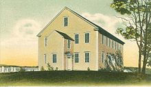
The Rockingham Meetinghouse - a Puritan church building as it was common in New England - dates from 1796 and has remained largely unchanged since then. Since 2000 it has been on the list of National Historic Landmarks in Vermont and is therefore a listed building.
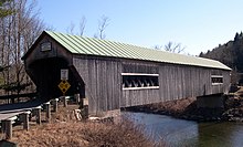
The more than 140-year-old Bartonsville Covered Bridge , which is also listed, was completely destroyed in 2011 by floods caused by Hurricane Irene .
Religions
The Congregational Church was founded in Rockingham in 1770 , the Episcopal Church in Bellows Falls in 1798 , and the Baptists and Methodists founded a congregation in 1842 .
Population development
| Census Results - Town of Rockingham, Vermont | ||||||||||
|---|---|---|---|---|---|---|---|---|---|---|
| year | 1700 | 1710 | 1720 | 1730 | 1740 | 1750 | 1760 | 1770 | 1780 | 1790 |
| Residents | 1235 | |||||||||
| year | 1800 | 1810 | 1820 | 1830 | 1840 | 1850 | 1860 | 1870 | 1880 | 1890 |
| Residents | 1684 | 1954 | 2155 | 2272 | 2330 | 2837 | 2904 | 2854 | 3797 | 4579 |
| year | 1900 | 1910 | 1920 | 1930 | 1940 | 1950 | 1960 | 1970 | 1980 | 1990 |
| Residents | 5809 | 6207 | 6231 | 5302 | 5737 | 5499 | 5704 | 5501 | 5538 | 5484 |
| year | 2000 | 2010 | 2020 | 2030 | 2040 | 2050 | 2060 | 2070 | 2080 | 2090 |
| Residents | 5309 | 5282 | ||||||||
Culture and sights
Buildings
The following structures in Rockingham have been added to the National Register of Historic Places
- Bartonsville Covered Bridge - it spans the Williams River south of Bartonsville (listed 1973)
- Worrall Covered Bridge - north of Rockingham across the Williams River (listed 1973)
- Hall Covered Bridge - To the west of Bellows Falls over the Saxtons River (Listed 1973)
- Parker Hill Rural Historic District - Parker Hill and Lower Parker Hill Roads (Listed 1993)
- Rockingham Meeting House (listed 1979)
- Rockingham Village Historic District - Meeting House Rd., Rockingham Hill Rd. (Listed 2008)
- Williams River Route 5 Bridge - over the Williams River (listed 1991)
- Adams Gristmill Warehouse - Bridge St., Bellows Falls ( Listed 1990)
- Bellows Falls Co-operative Creamery Complex - Bridge St., Bellows Falls (Listed 1990)
- Bellows Falls Petroglyph Site (VT-WD-8) - Bridge St., Bellows Falls (Listed 1990)
- Bellows Falls Times Building - Bridge and Island streets, Bellows Falls (listed 1990)
- Bellows Falls Downtown Historic District - Depot, Canal, Rockingham, Bridge, Mill and Westminster Sts. (placed under monument protection 1982)
- Bellows Falls Neighborhood Historic District - Atkinson, Westminster, School, and Hapgood Sts., Hapgood Pl., And Burt St., Henry St., South St., Hadley St., and Temple Pl .; also Center, Front, Old Terrace and Pine Sts., Bellows Falls (Listed 2002)
- Gas Station at Bridge and Island Streets - (listed 1990)
- George-Pine-Henry Street Historic District - 5-22 George St .; 1-17 Pine St .; 32-44 Henry St., Bellows Falls (listed 2010)
- Vermont Academy Campus Historic District - 10 Long Walk, Saxtons River (Listed 2015)
- Saxtons River Village Historic District - (Listed 1988)
- Miss Bellows Falls Diner - (Listed 1983)
- Moore and Thompson Paper Mill Complex - Bridge St., Bellows Falls (Listed 1984)
- Oak Hill Cemetery Chapel - Off Pleasant St., Bellows Falls (listed 1991)
- William A. Hall House - 1 Hapgood St., Bellows Falls (Listed 1999)
- Howard Hardware Storehouse - Bridge St., Bellows Falls (listed 1990)
- Robertson Paper Company Complex - Island St., Bellows Falls (Listed 1990)
- Williams Street Extension Historic District - 51-58, 61-68, 70 Williams St., Bellows Falls (Listed 2010)
- Westminster Terrace Historic District - Along Westminster Terrace, in Bellows Falls and Westminster (Listed 2010)
Parks
In the center of the town is the Bellows Falls Village Forest and to the west the Dorand State Forest protrudes into the town.
Economy and Infrastructure
traffic
The Interstate 91 into a north-south direction along the eastern border of the Town. US Highway 5 follows its course from Springfield in the north to Westminster in the south. An Amtrak station is located in Bellows Falls.
Public facilities
The Rockingham Memorial Hospital is located in Bellows Falls and the surrounding area the relevant hospital.
education
Bellows Falls and Saxtons River are part of the Windham Northeast Supervisory Union. Saxtons River is home to the Saxtons River Elementary School with classes from grades one to four. In Bellows Falls, the Central Elementary , Bellows Falls Middle School, and Bellows Falls Union High School
The Vermont Academy is a private college in Saxtons River.
The Rockingham Free Public Library is located on Westminster Street in Bellows Falls. The Rockingham Library Society was founded in 1799 and in 1887 the library was called Rockingham Free Public Library. In 1888 she moved into a room in the newly built Opera House. In 1908 the people of Rockingham decided to purchase land to build a library on Westminster Street. Money for this was donated by the philanthropist and steel tycoon Andrew Carnegie .
Personalities
Personalities who have worked on site
- John S. Barry (1802–1870), politician and governor of Michigan
- Thomas P. Salmon (born 1932), governor of Vermont
literature
- Zadock Thompson: History of Vermont, natural, civil and statistical, in Three Parts . Part 3. Chauncey Goodrich, Burlington 1842, p. 150 f . ( Digitized version ).
- Lyman Simpson Hayes: History of the Town of Rockingham, Vermont including the Villages of Bellows Falls, Saxtons River, Rockingham, Cambridgeport and Bartonsville, 1753-1907, with Family Genealogies. Published by the Town, Bellows Falls VT 1907, ( digitized ).
Web links
- Town homepage (together with Bellows Falls)
- Profile of the municipality on the official portal www.Vermont.gov
- Entry at VirtualVermont (English) ( Memento from March 26, 2017 in the Internet Archive )
Individual evidence
- ↑ Rockingham in the United States Geological Survey's Geographic Names Information System , accessed March 17, 2012
- ↑ Population data from the 2010 US Census in the American Factfinder
- ^ Signal Hill . In: peakery.com . ( peakery.com ).
- ↑ Coordinates of the locations of the Census Authority 2010
- ↑ Our Community . ( rockbf.org ).
- ↑ Rockingham, Vermont (VT 05101) profile: population, maps, real estate, averages, homes, statistics, relocation, travel, jobs, hospitals, schools, crime, moving, houses, news, sex offenders. In: city-data.com. www.city-data.com, accessed on February 26, 2017 (English).
- ^ A b Zadock Thompson: History of Vermont, natural, civil and statistical, in Three Parts . Part 3. Chauncey Goodrich, Burlington 1842, p. 150 ( digitized version ).
- ^ Lyman Simpson Hayes: History of the Town of Rockingham, Vermont including the Villages of Bellows Falls, Saxtons River, Rockingham, Cambridgeport and Bartonsville, 1753-1907, with Family Genealogies. Published by the Town, Bellows Falls VT 1907, ( digitized ).
- ↑ Population 1790–2010 according to the census results
- ^ Dorand State Forest | fpr. In: vermont.gov. fpr.vermont.gov, accessed February 26, 2017 .
- ^ Windham Northeast Supervisory Union | WNESU official site. In: wnesu.org. Retrieved February 26, 2017 (American English).
- ↑ Central Elementary School | A site for CES. In: ceshome.org. Retrieved February 26, 2017 (American English).
- ↑ Bellows Falls Middle School | BFMS site. In: bfmiddleschool.org. Retrieved February 26, 2017 (American English).
- ↑ Bellows Falls Union High School | BFUHS website. In: bfuhs.org. Retrieved February 26, 2017 (American English).
- ↑ Vermont Academy | A Private Boarding and Day School. In: vermontacademy.org. Retrieved February 26, 2017 (English).
- ^ Rockingham Free Public Library - History of the Rockingham Library. In: rockinghamlibrary.org. Retrieved February 26, 2017 (English).


