Sebaldus settlement
The Sebaldussiedlung (formerly also known as Gartenstadt Süd ) is a residential area in the southeast of the Middle Franconian city of Erlangen , which was created after the Second World War . The name of the district comes from the location on a cleared area of the Sebalder Reichswald . This in turn is after the main church of the same name, north of Pegnitz situated Nuremberg district named.
history
Immediately after the end of the war in 1945, the city administration gave a community of settlers a 56,000 square meter plot of land on the edge of the Sebalder Reichswald, deserted by clear cutting . Depending on the number of members, the area was divided into 107 plots ranging in size from 380 to 600 square meters and initially used exclusively as an allotment garden colony. The Sebaldus-Siedlergemeinschaft, founded in spring 1949, carried out the development of the area, which was incorporated into Erlangen in 1950 , with a high proportion of its own work . Initially, there should only be a single entrance from Gebbertstrasse . On January 27, 1954, Sebaldusstraße and Lupinen-, Heide- and Ginsterweg were given their names. In the spring of 1954, the construction of around 60 apartments financed by loans from the Bayerische Staatsbank in 36 two-storey one- or two-family houses began. By June 1959, the houses on 100 of the 107 lots in the Sebaldussiedlung had been completed and three were under construction.

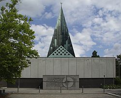
In the years 1959 to 1961, a much larger quarter was built immediately south of it, extending to the new city limits . This is characterized by curved streets and multi-storey residential buildings with flat roofs . In addition, some green areas were created in which remnants of the “Steckleswald” forest have been preserved, including the 12,000 square meter Theodor Heuss plant . Around 300 Siemens apartments were built here for their employees. In addition, numerous expellees settled down, which was reflected in the naming of the streets (e.g. Breslauer Strasse, Stettiner Strasse, Marienbader Strasse and Egerlandstrasse). In this area of Sebaldus the Catholic emerged parish church of St. Sebald (built 1966/67) and the Protestant Thomas Church (built 1966-69). The Michael-Poeschke- Grundschule (Liegnitzer Straße 22) and the Erlangen Special Education Center (Liegnitzer Straße 24) are also located here .
Adjacent to the Sebaldussiedlung numerous buildings of the Friedrich Alexander University and other research institutions have been built on an area of around 60 hectares since the 1960s . The decision to build the so-called southern area was made in 1962. First, in May 1964, construction of the technical faculty began on Egerland and Erwin-Rommel-Strasse. Numerous new buildings in the 1970s created an engineering campus on the site. In 1975, the relocation of the first scientific facilities to the southern area began. The Physikum and Biologikum were established in the 1980s on a site east of the Sebaldus settlement. With the building for the mathematics and computer science departments completed in 2011 and the chemical center opened in 2017, new buildings have recently been built on the southern site. Several non-university research institutions such as the Fraunhofer Institute for Integrated Circuits and the Max Planck Institute for the Physics of Light are also located in the immediate vicinity of the Sebaldus settlement.
literature
- Christoph Friedrich, Bertold Freiherr von Haller, Andreas Jakob (Hrsg.): Erlanger Stadtlexikon . W. Tümmels Verlag, Nuremberg 2002, ISBN 3-921590-89-2 ( complete edition online ).
Individual evidence
- ↑ a b Andreas Jakob: Sebaldussiedlung. In: Erlanger Stadtlexikon.
- ↑ Andreas Jakob: South area. In: Erlanger Stadtlexikon.
Coordinates: 48 ° 34 ′ 40.8 ″ N , 11 ° 1 ′ 18.3 ″ E
