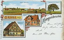
Kriegenbrunn
|
Kriegenbrunn
City of Erlangen
Coordinates: 49 ° 33 ′ 18 ″ N , 10 ° 57 ′ 14 ″ E
|
|
|---|---|
| Height : | 299 (283-304) m |
| Area : | 4.89 km² |
| Residents : | 1321 (Dec. 31, 2007) |
| Population density : | 270 inhabitants / km² |
| Incorporation : | July 1, 1972 |
| Postal code : | 91056 |
| Area code : | 09131 |
|
The statistical district 62 (Kriegenbrunn) and the district Kriegenbrunn in Erlangen
|
|
Kriegenbrunn is a statistical district and subdistrict in the district southwest of the independent city of Erlangen in Bavaria administrative district of Middle Franconia .
location
Kriegenbrunn is located in the southwest of Erlangen. In the north, the federal motorway 3 runs past the village, in the east the Main-Danube Canal . The village lies on a plateau between Regnitz and Mittlerer Aurach . This level is also called Römerreuth . According to legend, the Romans are said to have suffered a defeat here.
history
Traces of first settlement are blades , scrapers and arrowheads from the Neolithic Age . These were made from flint bulbs. This type of tubers can be found in three different places in Kriegenbrunn. These tubers were formed around 80 million years ago.
The next evidence of settlement is a clan grave from the Hallstatt period in the Regnitzgrund (Krähenholz). Seven people were buried in this grave at that time. This was around 600 BC. Further finds from this time are ceramic shards as well as glass beads and possibly another grave. But this still needs to be researched. Further fragments from the 8th century prove the presence of people, this is likely to be the time when Kriegenbrunn was built.
It was first mentioned in 1132 in connection with the founding of the Heilsbronn monastery . At that time, an "Egino von Chriegenbronnen" was named as a witness in the monastery deed of foundation. The Lords of Kriegenbrunn were then employed as ministerials to administer the fief . At that time Frauenaurach and Hüttendorf also belonged to this .
Approx. 100 years later this name appears again in many documents, in Bamberg in connection with the canon Egino. This name can be found in documents from 1213 to 1242. He lived in Bamberg Cathedral, where he is also buried. The day of his death was January 30, 1242.
The place name has changed several times. First the village was called "Chriec gen Bronnen", later "Krieg am Bronnen", then "Kriegenbronn" and finally, from the middle of the 17th century, "Kriegenbrunn".
On January 1, 1972, Kriegenbrunn was incorporated into the city of Erlangen.
traffic
Kriegenbrunn is located on the now closed Erlangen-Bruck-Herzogenaurach railway line . It had its own train station and freight yard. According to current planning (2017), the Erlangen city-suburban railway should run on the same route .
Others
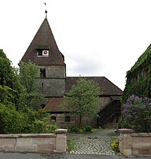
- The Evangelical Lutheran St. Johannis Church is a fortified church . Its history goes back to the 9th century.
- The Franken II power plant , which was in operation from 1967 to 2001, brought the municipality, which was independent until 1972, considerable tax revenue.
Picture gallery
Transport ship leaving the Kriegenbrunn lock of the Main-Danube Canal , built in 1970 , 2011
Former Kriegenbrunn station on the Erlangen-Bruck-Herzogenaurach railway line that was closed on this section , 2010
See also
Individual evidence
- ^ Wilhelm Volkert (ed.): Handbook of Bavarian offices, communities and courts 1799–1980 . CH Beck, Munich 1983, ISBN 3-406-09669-7 , p. 601 .


