Sepetiba
| Sepetiba | |
|---|---|
| Coordinates | 22 ° 58 ′ 0 ″ S , 43 ° 41 ′ 0 ″ W |
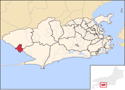
 Location in Rio de Janeiro Location in Rio de Janeiro
|
|
| Basic data | |
| Country | Brazil |
| Rio de Janeiro | |
| city | Rio de Janeiro |
| ISO 3166-2 | BR-RJ |
| Sub-prefecture | Zona Oeste |
| surface | 11.6 km² |
| Residents | 56,575 |
| density | 4,868.3 Ew. / km² |
Sepetiba is a district in the west of the city of Rio de Janeiro . In the north, the place borders on Santa Cruz and Guaratiba . Sepetiba has an area of 11,621 km² and a population of around 57,000. The place is surrounded to the south by the coastal mountains and the Atlantic coastal forest. There are still residents today who have indigenous origins.
history
The name “Sepetiba” has its origins in the indigenous Tupi language . There he has an alternative spelling "Sipitiba" and means "sítio dos Sapés", or "Sapezal" (translated field country ). During the colonization, Sepetiba was an important historical place and was proclaimed a province of Brazil by King João VI of Portugal.
Footnotes
- ↑ Bairros. Prefeitura da Cidade do Rio de Janeiro, 2010, archived from the original on September 2, 2013 ; Retrieved January 5, 2014 .
Web links
Commons : Sepetiba - collection of images, videos and audio files

