
Briescht Spree Bridge
Coordinates: 52 ° 6 ′ 19 ″ N , 14 ° 7 ′ 14 ″ E
| Briescht Spree Bridge | ||
|---|---|---|
 |
||
| use | Road traffic, pedestrians, cyclists | |
| Convicted | Local road , Spreeradweg , Märkische Schlösser-Tour | |
| Subjugated | Spree and Spreealtarm | |
| place | Briescht , municipality of Tauche | |
| construction | Drawbridge , Pfahljoch Bridge | |
| overall length | 71.74 m | |
| width | 6.50 m | |
| completion | 1992 | |
| location | ||
|
||

The Spreebrücke Briescht is a road, bicycle and pedestrian bridge over the Spree in Briescht , a district of the Brandenburg municipality of Tauche in the Oder-Spree district .
The 72 meter long drawbridge was built from wood in 1992 based on the historical model. The bascule bridge consists of eight bridge fields that rest on pile yokes. The Briescht railway bridge spans the Spree around two hundred meters to the east . The railway bridge, which was blown up in 1945 and rebuilt in 1951, leads the route of the Niederlausitz Railway , which was shut down in this section, over the river.
Geography and natural space
Geology and conservation
The Pfahljochbrücke spans the Spree south of the Briescht village center, which flows from west to east in this section of the river in the glacial Brieschter valley under the name Krumme Spree and separates the Beeskower Platte from the Lieberoser Platte to the southeast . The southern part of the bridge crosses a short oxbow lake that branches off from the Spree directly in front of the bridge. The wooden bridge fits in well with the landscape of the protected floodplain .
The river valley belongs to the Krumme Spree landscape protection area and, as an FFH area Spree, is part of the coherent European ecological network of special protection areas Natura 2000 . The profile of the Federal Agency for Nature Conservation (BfN) characterizes the 2,324 hectares comprehensive FFH area under the number 3651 to 303 as follows: Nationally significant rivers with outstanding connectivity and spread function for otter , beaver and numerous species of fish, Aue with typical habitats. To the east of the railway bridge is the Spreebögen nature conservation and FFH area near Briescht .
Location and overpass
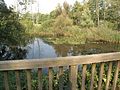
The bridge crosses the local road "An der Spree" over the river, which branches off from Brieschter "Dorfstraße" ( district road K 6724 ). It connects the Brieschter residential area "Schwarzer Kater", which is south of the Spree, to the place and ends there. In addition, the bridge and road are part of the Spreeradweg and the Märkische Schlösser-Tour cycle path . After the end of the road, the cycle paths continue to Rocher, a residential area in the Trebatsch district . A resting place for water hikers , cyclists and hikers has been set up on the north bank of the river below the bridge , and tents can be set up on the extensive meadow. In front of the bridge, above the rest area, is the only restaurant in the village.
Construction and material
The bridge was built in 1992 by a consortium . The client was the Beeskow District Office , civil engineering department. The planning and statics were carried out by the F. Pott engineering office from Nordhorn - as was the case with the Werder Spree Bridge built a year earlier .
The entire construction is made of hardwood . Were used Basralocus from South America and Bongossi timber from Cameroon , an ironwood of particular hardness and high density . The steel parts used are either hot-dip galvanized or made of V4A steel . The 71.74 m long structure is divided into eight bridge fields that rest on wooden pile yokes. The shipping opening has a clear width of 8.50 m and is designed as a movable flap. The flap is opened and closed with 6.0 t iron weights via pulleys using an electric cable winch . The scales with the iron weights are located at a height of 9 m above the bridge deck. The pylons reach a height of 12 m. The total weight of the flap part (flap, pylons, scales) is 36.8 t. The width between the railings is 6.5 m, the usable lane width is 5.5 m.
The bridge is designed for the vehicle class SLW 30 , i.e. for a total load of 300 kilonewtons , wheel load of 50 kN and axle load of 130 kN. The desired service life of the bridge is estimated at 50 to 70 years and, according to the client, corresponds to the service life of a reinforced concrete bridge .
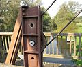
Steel cable

Part of the flap, looking north to the village center of Briescht

Spree with mooring and resting place for water hikers
Southern part of the bridge over an oxbow lake of the river
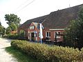
Restaurant at the northern entrance to the bridge


Web links
Individual evidence
- ↑ Olaf Juschus: The young moraine south of Berlin - investigations into the young Quaternary landscape development between Unterspreewald and Nuthe. S. 2. Dissertation, Humboldt University Berlin, 2001. Also in: Berliner Geographische Arbeit 95. ISBN 3-9806807-2-X , Berlin 2003. See Figure 2 Plates and glacial valleys in the young moraine south of Berlin in Chapter 1 and Chapter 4 Fig. 32 and subsections 4.3.4.3 and 4.3.4.5 .
- ↑ 3651-303 Spree. (FFH area) Profiles of the Natura 2000 areas. Published by the Federal Agency for Nature Conservation . Retrieved November 25, 2017.
- ↑ Federal Agency for Nature Conservation (BfN): Map service for protected areas in Germany. Section dive (scroll down a bit).
- ↑ Brandenburg viewer, digital topographic maps 1: 10,000 (menu - "More data" - click and select accordingly; switch to the district boundaries "real estate cadastre" and there "districts".)
- ↑ Information board on the Spreebrücke Briescht on site, as of 2014.
- ^ Community Tauche: Briescht